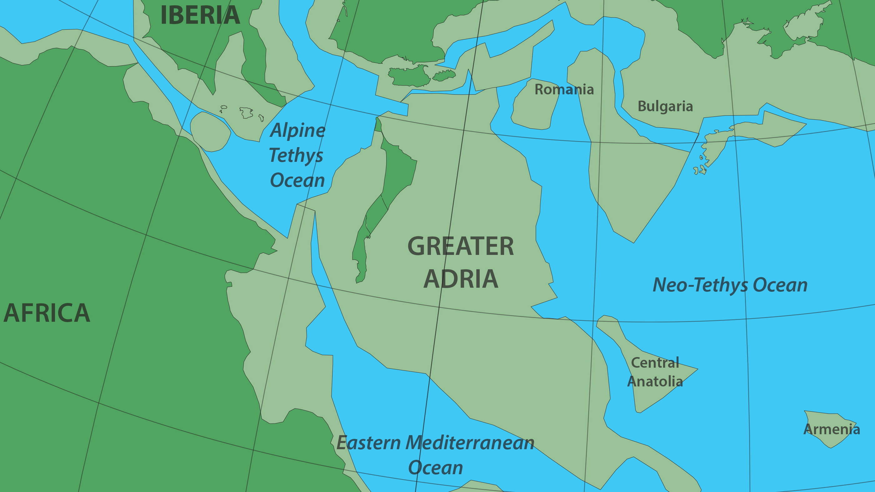
Greater Adria, a lost continent hiding in plain sight
Most of it was eaten by Earth's mantle, but scraped-off bits survive in the Alps and other mountain ranges.
- Following a 10-year survey, geologists discover a lost continent in the Mediterranean.
- 'Greater Adria' existed for 100 million years, and was probably "great for scuba diving".
- Most of it has been swallowed up by Earth's mantle, but bits of it survive.
Complex geology
<img type="lazy-image" data-runner-src="https://assets.rebelmouse.io/eyJhbGciOiJIUzI1NiIsInR5cCI6IkpXVCJ9.eyJpbWFnZSI6Imh0dHBzOi8vYXNzZXRzLnJibC5tcy8yMjAxMjUxMC9vcmlnaW4uanBnIiwiZXhwaXJlc19hdCI6MTYzMDE4OTI2MH0.IenexvWxtpY_jWTI8pipCmvDmBPliVqR7Hgdf8fnpHU/img.jpg?width=980" id="b8d85" class="rm-shortcode" data-rm-shortcode-id="34380b4a09917c1b51d9e41bcefb057d" data-rm-shortcode-name="rebelmouse-image" alt="Topographic map of the Mediterranean Sea basin, once home to the continent of Greater Adria." />Topographic map of the Mediterranean Sea basin, once home to the continent of Greater Adria.
Image: NASA / public domain
<p>Move over, Atlantis. Not all lost continents are myths; here's one whose existence has just been verified by science. Greater Adria broke off from North Africa 240 million years ago. About 120 million years later, it started sinking beneath Southern Europe. But bits of it remain, scattered across local mountain ranges.</p><p><span></span>It's the geological similarities in those mountains that had led scientists to hypothesize the presence of an ancient continent in the Mediterranean. But the region's geology is so complex that only recent advances in computing—and a 10-year survey by an international team of scientists—were able to produce a geo-historical outline of that former land mass. This is the very first map of the world's latest lost continent (1).</p><p><span></span>The 100-million-year history of Greater Adria starts nearly a quarter of a billion years ago. The world was a very different place back then. It was just recovering from the Permian-Triassic extinction, which came pretty close to wiping out all life on Earth. The planet was repopulated by the first mammals and dinosaurs. </p>Supercontinental break-up
<img type="lazy-image" data-runner-src="https://assets.rebelmouse.io/eyJhbGciOiJIUzI1NiIsInR5cCI6IkpXVCJ9.eyJpbWFnZSI6Imh0dHBzOi8vYXNzZXRzLnJibC5tcy8yMjAxMjUxMS9vcmlnaW4ucG5nIiwiZXhwaXJlc19hdCI6MTY0NTc1MjUzOH0.FbnnsJ0E5VT3P_iIhaFCq0bhrQ1YmOytSoPP1JPRwJY/img.png?width=980" id="69ff1" class="rm-shortcode" data-rm-shortcode-id="30f64dbadb64a83eb8c3c9fc677278a0" data-rm-shortcode-name="rebelmouse-image" alt="All together now: the supercontinent of Pangaea (335-175 million years ago)." />All together now: the supercontinent of Pangaea (335-175 million years ago).
Image: Kieff / GFDL 1.2
<p>Oblivious that biological imperative, Earth's geology was on a course of its own: fragmentation. At that time, the planet's land masses had coagulated into a single supercontinent, <a href="https://bigthink.com/news/pangea-politico-map-reveals-modern-countries-on-the-ancient-supercontinent" target="_blank" rel="noopener noreferrer">Pangaea.</a> </p><p>Around 240 million years ago, a Greenland-sized piece of continental plate broke off from what would become North Africa and started drifting north. Between 120 and 100 million years ago, the continent smashed into Southern Europe. Even though the speed of that collision was no more than 3 to 4 cm per year, it ended up shattering the 100-km thick crust. </p><p>Most of the continental plate was pushed under Southern Europe and swallowed up by Earth's mantle, a process known as subduction. Seismic waves can still detect the plate, now stuck at a depth of up to 1500 km. <br></p><p>But some of the sedimentary rocks on top were too light to sink, so they were scraped off and got crumpled up—the origin of various mountain chains across the Mediterranean region: the Apennines in Italy, parts of the Alps, and ranges in the Balkans, Greece and Turkey. </p>Death and birth
<span style="display:block;position:relative;padding-top:56.25%;" class="rm-shortcode" data-rm-shortcode-id="b6e9d18f5ebe97540b2acf42bfddcdfa"><iframe type="lazy-iframe" data-runner-src="https://www.youtube.com/embed/tf9r2SmTJ1A?rel=0" width="100%" height="auto" frameborder="0" scrolling="no" style="position:absolute;top:0;left:0;width:100%;height:100%;"></iframe></span><p>Flowing from present to deep past, this time-lapse reconstruction of the geological history of the Mediterranean shows the death and birth (in that order) of Greater Adria in unprecedented amounts of detail.</p><p>Some bits of Greater Adria survived both the shave-off into mountainhood and death by subduction. "The only remaining part of this continent is a strip that runs from Turin via the Adriatic Sea to the heel of Italy's boot," says Douwe van Hinsbergen, Professor of Global Tectonics and Paleogeography at Utrecht University, and the study's principal researcher. That's an area geologists call 'Adria', so the team, consisting of scientists from Utrecht, Oslo and Zürich, called the lost continent 'Greater Adria'. </p><p>What was the continent like? A shallow continental shelf in a tropical sea, where sediments were slowly turned into rock, Greater Adria possibly resembled Zealandia, a largely submerged continent with bits sticking out (i.e. New Zealand and New Caledonia), or perhaps the Florida Keys, an archipelago of non-volcanic islands. Either way, dotted with islands and archipelagos above the water, and lots of coral below, it was "probably good for scuba diving," Van Hinsbergen says.<br></p><p>It took scientists this long to produce the first map of Greater Adria not just because the Mediterranean is, in the words of Van Hinsbergen, "a geological mess (…) Everything is curved, broken and stacked. Compared to this, the Himalayas represent a rather simpler system." Greater Adria perished by subduction and scraping-off. The Himalayas emerged by the collision of two continents. </p>Ore deposits
<img type="lazy-image" data-runner-src="https://assets.rebelmouse.io/eyJhbGciOiJIUzI1NiIsInR5cCI6IkpXVCJ9.eyJpbWFnZSI6Imh0dHBzOi8vYXNzZXRzLnJibC5tcy8yMjAxMjUxOS9vcmlnaW4uanBnIiwiZXhwaXJlc19hdCI6MTY1NDU3MzkxN30.LM6bVix9CeDUg5vzUre2skxcxyk0hYHQFUjLatA29R0/img.jpg?width=980" id="02403" class="rm-shortcode" data-rm-shortcode-id="7a95c1d043c006bd0853cdf3564fec5e" data-rm-shortcode-name="rebelmouse-image" alt="A reconstruction of Greater Adria, Africa and Europe about 140 million years ago. In lighter green, submerged parts of continental shelves." />A reconstruction of Greater Adria, Africa and Europe about 140 million years ago. In lighter green, submerged parts of continental shelves.
Image: Utrecht University
<p>The region also has a complex geopolitical makeup, obliging the researchers to piece together evidence from 30 different countries, from Spain to Iran, "each with its own geological survey, own maps, own ideas about evolutionary history. Research often stops at national borders."<br></p>So what has geology learned from the discovery of Greater Adria?<ul><li>First off, that its hypothesis was right: Geological similarities across the Mediterranean really did point to a lost continent, now found.</li><li>Secondly, the reconstruction of Greater Adria has also taught geologists that subduction is the basic way in which mountain belts are formed.</li><li>They've also learned a great deal about volcanism and earthquakes, and "(we) can even predict, to a certain extent, what a given area will look like in the far future," van Hinsbergen says.</li><li>Finally, and practically, these insights will help scientists and surveyors to identify and locate ore deposits and other useful materials in mountain belts. </li></ul>Why the south of Westeros is the north of Ireland
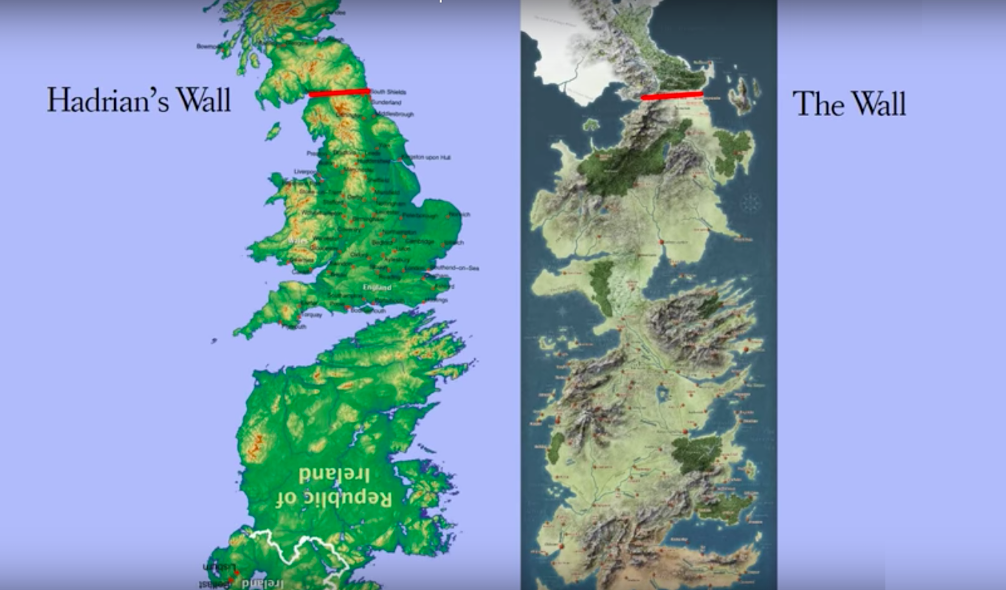
As Game of Thrones ends, a revealing resolution to its perplexing geography.
- The fantasy world of Game of Thrones was inspired by real places and events.
- But the map of Westeros is a good example of the perplexing relation between fantasy and reality.
- Like Britain, it has a Wall in the North, but the map only really clicks into place if you add Ireland.
A world of "goblin porn"
<img type="lazy-image" data-runner-src="https://assets.rebelmouse.io/eyJhbGciOiJIUzI1NiIsInR5cCI6IkpXVCJ9.eyJpbWFnZSI6Imh0dHBzOi8vYXNzZXRzLnJibC5tcy8xOTQ5MDExMi9vcmlnaW4ucG5nIiwiZXhwaXJlc19hdCI6MTY1MjQ1MzM1MX0.7Nt6e30kVePubmQk9r-JGt5vIUuH9MuLuRzTNjcyAFI/img.png?width=980" id="acfba" class="rm-shortcode" data-rm-shortcode-id="2e869701dc1f5a1bc69363de4125f6c9" data-rm-shortcode-name="rebelmouse-image" />The Known World, with Westeros top left. Image source: A Wiki of Ice and Fire / public domain
<p>Warning: if you haven't caught up, mild spoiler ahead.</p><p>"Hell is other people talking about <em>Game of Thrones</em>," <a href="https://www.theguardian.com/commentisfree/2019/may/14/i-dont-watch-game-of-thrones-which-makes-me-a-lot-more-interesting-than-you" target="_blank">writes Arwa Mahdawi</a> in <em>The Guardian</em> this week. A few days more, and the eighth and final season of the show she dubs "densely plotted goblin porn" — clearly, she's not a fan — will be over.</p><p>Meanwhile, hell is hard to avoid. When it comes to following GoT, I'm on Team Arwa (a.k.a. <a href="https://www.facebook.com/SLContentProvider/videos/10155869239233512/?v=10155869239233512" target="_blank">Team Stewart</a>) but even we have heard rumors about a sudden bout of genocidal mania, and Daenerys perhaps no longer being <a href="https://www.washingtonpost.com/business/2019/05/13/why-least-parents-may-be-having-regrets-after-last-nights-game-thrones/?utm_term=.5be533887eb0" target="_blank">such a good baby name</a>.</p><p>Fortunately for map nerds, GoT's dense plotting also extends to its topography. Just like the series' peoples, protagonists and events — often borrowed from actual history, then slightly altered — its fictional map is more than loosely based on ours.</p>Maps to frame fantasy
<img type="lazy-image" data-runner-src="https://assets.rebelmouse.io/eyJhbGciOiJIUzI1NiIsInR5cCI6IkpXVCJ9.eyJpbWFnZSI6Imh0dHBzOi8vYXNzZXRzLnJibC5tcy8xOTQ5MDEwNy9vcmlnaW4ucG5nIiwiZXhwaXJlc19hdCI6MTYzNDc2MDMwNn0.RWN-x_wlWjZm6N6SZ-m-M5JilodSGIOaRhsZ1XoRt30/img.png?width=980" id="a0a0f" class="rm-shortcode" data-rm-shortcode-id="c58983afcc622614e06589c42f56871a" data-rm-shortcode-name="rebelmouse-image" />The first part of Gulliver's Travels (1726) contained a Map of Lilliput and Blefuscu, showing the fictional islands positioned in the Indian Ocean, north-west of Van Diemen's Land (now Tasmania). Image source: British Library / public domain
<p>Fantasy locations have been a literary device at least since Plato spun his stories about <a href="https://bigthink.com/strange-maps/394-athanasius-kirchers-atlantis" target="_self">Atlantis</a>, back in the 4th century BC. From Plato only a description of the island survives, more recent tales of fictional geography came with a map: Thomas More's <a href="https://bigthink.com/strange-maps/51-a-colour-map-of-utopia" target="_self"><em>Utopia</em></a>, Jonathan Swift's Lilliput (and other islands visited by Gulliver), and Robert Louis Stevenson's <a href="https://bigthink.com/strange-maps/378-x-m-aarrrh-ks-the-spot" target="_self"><em>Treasure Island</em></a>. </p><p>The watershed fantasy map, the one that spawned a thousand imitations, is the map of Middle-Earth, <a href="https://www.countrylife.co.uk/out-and-about/focus-hand-drawn-maps-jrr-tolkien-launched-middle-earth-181987" target="_blank">created by J.R.R. Tolkien himself</a> (from the 1920s to the 1940s): as the endpapers to the <em>Lord of the Rings</em> trilogy, they framed the wanderings of the Fellowship, the movements of armies and heroes, and the deep history underlying the narrative. </p><p>"I wisely started with a map and made the story fit," Tolkien once quipped. George R.R. Martin did it the other way around: he envisaged the opening scene of the first book of <em>A Song of Ice and Fire </em>(the book series adapted as GoT) and built the tale — and the world around it — from there.</p>Not just a badly drawn Britain
<img type="lazy-image" data-runner-src="https://assets.rebelmouse.io/eyJhbGciOiJIUzI1NiIsInR5cCI6IkpXVCJ9.eyJpbWFnZSI6Imh0dHBzOi8vYXNzZXRzLnJibC5tcy8xOTQ5MDExNS9vcmlnaW4uanBnIiwiZXhwaXJlc19hdCI6MTY1NjAyNDMzN30.kyFri8hL3N-4bZbulzhawa0yDAONO_tfEi6eis1XOVI/img.jpg?width=980" id="c814e" class="rm-shortcode" data-rm-shortcode-id="2aa6bb52e9348162d213dc8a02da3ce5" data-rm-shortcode-name="rebelmouse-image" />Mighty Westeros side by side with tiny Britain. Image source: Imgur
<p>Only then did he take on the mantle of the First Cartographer, and it's his hand-drawn maps that appear in the books. Another similarity with Tolkien, whose <a href="https://bigthink.com/strange-maps/121-where-on-earth-was-middle-earth" target="_self">fantasy world was inspired by real geography</a> was that Martin also drew his world with one eye on the map of Europe, and especially the British Isles. </p><p>Most of the action, in the books and the series, takes place on the continent of Westeros (there is a whole Known World out there as well). There's an obvious parallel with Great Britain in the Wall in the North: at 700 feet high and 300 miles long, it is a clear extrapolation of Hadrian's Wall (a mere 73 miles long, and never higher than 20 feet). </p><p>Westeros is much bigger than Britain, though: about 3,000 miles from the Wall to the south coast, about six times the distance from Aberdeen to London. But Westeros is not just a badly drawn Britain, nor a mirrored version of its land mass (two popular theories). Things click into place — literally — if you do the following: </p><p>Take Ireland, turn it on its head, inflate it by about a third, and stick it to Britain's bottom (via a new land bridge called The Neck). And hey presto, there's Westeros.</p>Britain and Ireland, joined at the - ahem - south coast
<span style="display:block;position:relative;padding-top:56.25%;" class="rm-shortcode" data-rm-shortcode-id="c7ef3755e919b26847271564f3e9a260"><iframe type="lazy-iframe" data-runner-src="https://www.youtube.com/embed/ftc9rZIifYY?rel=0" width="100%" height="auto" frameborder="0" scrolling="no" style="position:absolute;top:0;left:0;width:100%;height:100%;"></iframe></span><p>In fact, Martin admitted as much at the 2014 Comic–Con: "If you want to know where a lot of fantasy maps come from, take a look at any map in the front of your favorite fantasy book and turn it upside down. Westeros began as upside-down Ireland. You can see the Fingers at the Dingle Peninsula."</p><p>This has some implications for the (presumed) parallels between locations in Westeros on one side, and Britain/Ireland on the other. For instance, King's Landing, the capital of Westeros, corresponds to Galway rather than London. </p><p>But such correspondences are futile. Each borrowing from actual history and geography is given a little twist, so people can argue until they're blue in the face whether the Red Wedding was inspired by the St. Bartholomew Day's Massacre or by the Black Dinner, whether the Dothraki are the Huns or the Mongols, and if Winterfell is Manchester or Leeds. </p><p>For some, King's Landing is reminiscent of old Constantinople. In the TV series, the old walled cities of Mdina (Malta) and Dubrovnik (Croatia) stand in for the capital. And Martin himself dreamt up the teeming city remembering the view of Staten Island from his childhood home in Bayonne, New Jersey. </p><p>For some, that tension with "real" history and geography adds a layer of enjoyment to GoT. Team Arwa can feign interest in a cartographic discovery that hardcore fans have made years ago, and will be happy only when the last dragon has finally landed. <br> <br></p>Five Hawks Down: watch the tragic migration of six Californian raptors
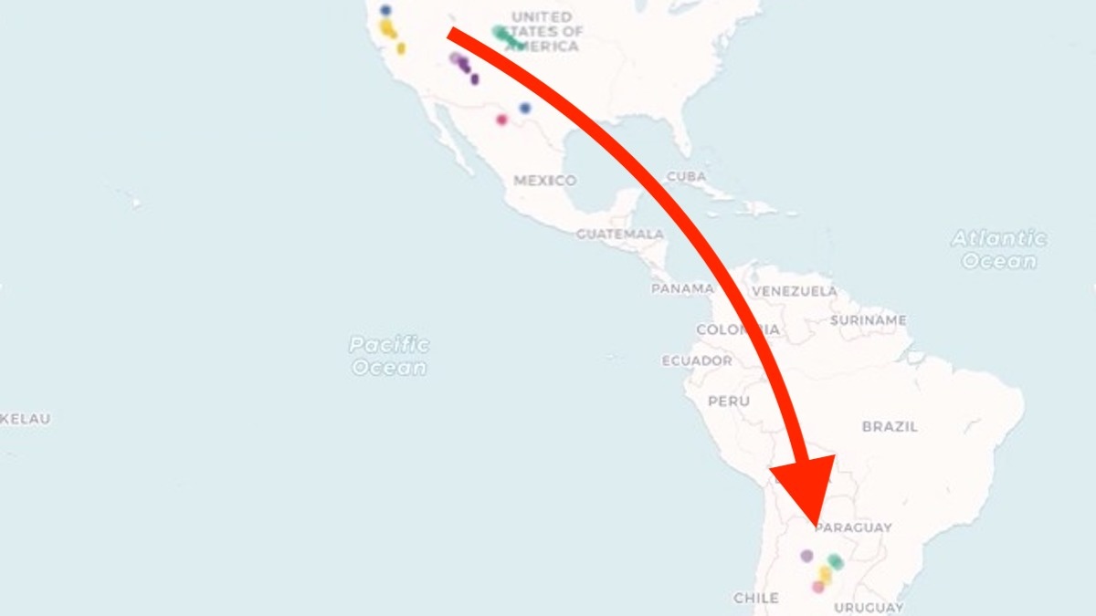
Tracking project establishes northern Argentina is wintering ground of Swainson's hawks
- Watch these six dots move across the map and be moved yourself: this is a story about coming of age, discovery, hardship, death and survival.
- Each dot is a tag attached to the talon of a Swainson's Hawk. We follow them on their very first migration, from northern California all the way down to Argentina.
- After one year, only one is still alive.
Discovered: destination Argentina
<img type="lazy-image" data-runner-src="https://assets.rebelmouse.io/eyJhbGciOiJIUzI1NiIsInR5cCI6IkpXVCJ9.eyJpbWFnZSI6Imh0dHBzOi8vYXNzZXRzLnJibC5tcy8xOTI3OTQ1NC9vcmlnaW4ucG5nIiwiZXhwaXJlc19hdCI6MTY3MDI1MTU2OH0.JaMqSOP4JN7FwI4VVR9egx3R-y6jURkHBx_AyXAi7BY/img.png?width=980" id="5327a" class="rm-shortcode" data-rm-shortcode-id="44ee9f8af916bef2df1eb0626097a6b8" data-rm-shortcode-name="rebelmouse-image" />Young Swainson's hawks were found to migrate to northern Argentina
Image: @TrackingTalons
<p>The <em>Buteo swainsoni </em>is a slim, graceful hawk that nests from the Great Plains all the way to northern California. </p><p>It feeds mainly on insects, but will also prey on rodents, snakes and birds when raising their young. These learn to fly about 45 days after hatching but may remain with their parents until fall migration, building up flying skills and fat reserves. </p><p>A common sight in summer over the Prairies and the West, Swainson's hawks disappear every autumn. While it was assumed they migrated south, it was long unclear precisely where they went. </p><p>A group of researchers that has been studying raptors in northern California for over 40 years has now established exactly where young Swainson's hawks go in winter. The story of their odyssey, <a href="https://www.reddit.com/r/dataisbeautiful/comments/azy9x9/first_year_of_life_for_six_swainsons_hawks_oc/" target="_blank">summarized in a 30-second clip</a> (<em>scroll down</em>), is both amazing and shocking. <span></span></p>Harnessing the hawks
<img type="lazy-image" data-runner-src="https://assets.rebelmouse.io/eyJhbGciOiJIUzI1NiIsInR5cCI6IkpXVCJ9.eyJpbWFnZSI6Imh0dHBzOi8vYXNzZXRzLnJibC5tcy8xOTI3OTQ1NS9vcmlnaW4ucG5nIiwiZXhwaXJlc19hdCI6MTY0MTMwMTA4N30.oFghkTOyj9yYhzUN-YJu_Qy4BD44nl03KVGCRse4BLE/img.png?width=980" id="5ae98" class="rm-shortcode" data-rm-shortcode-id="dbb1b2f6b8e561c8573b834f14f78795" data-rm-shortcode-name="rebelmouse-image" />A Swainson's hawk, with tracking device.
Image: @TrackingTalons, found here on imgur.
<p>The team harnessed six Swainson's hawks in July, as they were six weeks old and just learning to fly. The clip covers 14 months, until next August – so basically, the first year of flight.</p><p>Each harness contains a solar-powered tracker and weighs 20 grams, which represents just 3% of the bird's body weight. To minimize the burden, only females were harnessed: as with most raptors, Swainson's hawk females generally are bigger than males. </p><p>The first shock occurs just one month (or about 2.4 seconds) from the start of the clip: the first dot disappears. The first casualty. A fledgling no more than two months old, who never made it further than 20 miles from its nest. </p><p>By that time, the remaining five are well on their way, clustering around the U.S.-Mexico border in Texas. Swainson's hawks usually travel at around 40 mph (65 km/h) but can almost double that speed when they're stooping (i.e. dive down, especially when attacking prey). <span></span></p>'Migration unrest'
<blockquote class="reddit-card" data-card-created="1552919967"><a href="https://www.reddit.com/r/dataisbeautiful/comments/azy9x9/first_year_of_life_for_six_swainsons_hawks_oc/">First year of life for six Swainson's Hawks [OC]</a> from <a href="http://www.reddit.com/r/dataisbeautiful">r/dataisbeautiful</a></blockquote> <script async src="//embed.redditmedia.com/widgets/platform.js" charset="UTF-8"></script><p>There's a strong genetic component to migration. As usual, the Germans have nice single word to summarize this complex concept: <em>Zugunruhe</em> ('tsook-n-roowa'), literally: 'migration unrest' (1). It denotes the seasonal urge of migratory animals – especially birds – to get on their way. <em>Zugunruhe</em> exhibits especially as restless behavior around nightfall. The number of nights on which it occurs is apparently higher if the distance to be traveled is longer. </p><p><span></span>The birds may have the urge to go south, but genetics doesn't tell them the exact route. They have to find that out by trial and error. Hence the circling about by the specimens in this clip: they're getting a sense of where to find food and which direction to go. Their migratory paths will be refined by experience – if they're lucky enough to survive that long.</p><p><span></span>Each bird flies solo: their paths often strongly diverge, and if they seem to meet up occasionally, that's just an illusion: even when the dots are close together, they can still be dozens if not hundreds of miles apart. </p>Panama snack stop
<img type="lazy-image" data-runner-src="https://assets.rebelmouse.io/eyJhbGciOiJIUzI1NiIsInR5cCI6IkpXVCJ9.eyJpbWFnZSI6Imh0dHBzOi8vYXNzZXRzLnJibC5tcy8xOTI3OTQ1Ni9vcmlnaW4ucG5nIiwiZXhwaXJlc19hdCI6MTYzOTk0MjA2M30.kxjZBGkfDFSWQUoO1ijkhFpWZCmsv2z5UAsGQGDEdYg/img.png?width=980" id="22f0c" class="rm-shortcode" data-rm-shortcode-id="0de6853b41ff80629e9ba0b66d66092e" data-rm-shortcode-name="rebelmouse-image" />The Central American isthmus is a major bird migration corridor
Image: @TrackingTalons
<p>They generally follow the same route as it is the path of least resistance: follow mountain ranges, stay over land. Like most raptors, Swainson's hawks migration paths are land-based: not just so they can roost at night, but mainly to benefit from the thermals and updrafts to keep them aloft. That reduces the need to flap wings, and thus their energy spend – even though the trip will take longer that way. </p><p><span></span>As this clip demonstrates, the land-migration imperative means the Central American isthmus is a hotspot for bird migration. Indeed, Panama and Costa Rica are favorite destinations for bird watchers, when the season's right. A bit to the north, Veracruz in Mexico is another bird migration hotspot. </p><p><span></span>It's thought most hawks don't eat at all on migration. This clip shows an exception to that rule: on the way back, one bird takes an extended stopover of a couple of weeks in Panama, probably spending its time there foraging for food. </p><p><span></span>So, when they finally arrive in northern Argentina, after 6 to 8 weeks' migration, the hawks are pretty famished. Until a few decades ago, they fed on locusts. For their own reasons, local farmers have been getting rid of those. The hawks now concentrate on grasshoppers, and basically anything else that's edible. </p><p><span></span>For first-time visitors, finding what they need is not easy. Three of the five dots go dark. These birds probably died from starvation. But two birds thrive: they roam the region until winter rears its head in South America, and it's time to head back north again, where summer is getting under way.</p><p><span></span>Both dots make it back across the border, but unfortunately, right at the end of the clip, one of the surviving two birds expires. </p>Harsh, but not unusual
<img type="lazy-image" data-runner-src="https://assets.rebelmouse.io/eyJhbGciOiJIUzI1NiIsInR5cCI6IkpXVCJ9.eyJpbWFnZSI6Imh0dHBzOi8vYXNzZXRzLnJibC5tcy8xOTI3OTQ1Ny9vcmlnaW4uanBnIiwiZXhwaXJlc19hdCI6MTYyMTU2NzE2MX0.CJNmLRwv-29GWME0k0lzv_TtdyVxGLbxgRp31_jDpgA/img.jpg?width=980" id="511a7" class="rm-shortcode" data-rm-shortcode-id="6578411e0425614f2ce342a3b5ad473d" data-rm-shortcode-name="rebelmouse-image" />This old lady is 27 years old, but still nesting.
Image: @TrackingTalons, found here on imgur.
<p>While a one-in-six survival rate may seem alarmingly harsh, it's not that unusual. First-year mortality for Swainson's Hawks is between 50% and 80%. Disease, starvation, predators and power lines – to name just a few common causes of death - take out a big number. </p><p><span></span>Only 10% to 15% of the young 'uns make it past their third or fourth year into adulthood, but from then on, annual survival rates are much better: around 90%. Adult Swainson's Hawks can expect to live into their low teens. There's one documented example of a female Swainson's Hawk in the wild who was at least 27 years old (and still nesting!)</p><p><span></span>The Californian population of Swainson's Hawks plummeted by about 90% at the end of last century but is now again increasing well. The monitoring project that produced this clip has been going for about four decades but is seeing its funding dry up. Check them out and consider supporting them (<em>see details below</em>). </p>Migration trajectory of B95, the 'Moonbird'.
<p>Not all migrating birds shun the ocean. Here's an incredible map of an incredible migration path that's even longer than that of the Swainson's hawks.</p><p><span></span>In February 1995, a red knot (<em>Calidris canutus rufa</em>) in Tierra del Fuego (southern Argentina) was banded with the tag B95. That particular bird, likely born in 1993, was recaptured at least three times and resighted as recently as May 2014, in the Canadian Arctic. </p><p><span></span>B95 is more commonly known as 'Moonbird', because the length of its annual migration (app. 20,000 miles; 32,000 km) combined with its extreme longevity (if still alive, it's 25-26 years old now) means its total lifetime flight exceeds the distance from the Earth to the Moon. </p><p><span></span>As many other shorebirds do, the red knot takes the Atlantic Flyway hugging the coastline and crossing to South America via the ocean.</p><p><span></span>B95 has become the poster bird of conservationists in both North and South America. A book titled <em>Moonbird: A Year on the Wind with the Great Survivor B95</em> (2012) received numerous awards, B95 has a statue in Mispillion Harbor on Delaware Bay and the City of Rio Grande on Tierra del Fuego has proclaimed B95 its natural ambassador.</p><p><span></span>Perhaps one day the nameless Swainson's Hawks in this clip, fallen in service of their ancestral instincts – against the odds of human increasing interference – will receive a similar honor. </p>22 months of Syria's civil war condensed into a 1-minute video
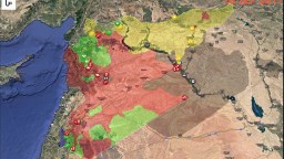
No, the Syrian civil war is not over. But it might be soon. Time for a recap.
- The War in Syria has dropped off the radar, but it's not over (yet).
- This 1-minute video shows how the fronts have moved – and stabilized – over the past 22 months.
- The clip runs, specifically, from 1 January 2017 to 4 November 2018 at the rate of 10 days per second.
January 2017: Peak ISIS
<img type="lazy-image" data-runner-src="https://assets.rebelmouse.io/eyJhbGciOiJIUzI1NiIsInR5cCI6IkpXVCJ9.eyJpbWFnZSI6Imh0dHBzOi8vYXNzZXRzLnJibC5tcy8xODkxOTAwNS9vcmlnaW4ucG5nIiwiZXhwaXJlc19hdCI6MTY1Nzk2ODcxMn0.GGYnNkw5JURTEmjqtVS16mJNFN2-JbzARbXc0NNfC-8/img.png?width=980" id="77502" class="rm-shortcode" data-rm-shortcode-id="9f627bce04a336ee93f62f300802f743" data-rm-shortcode-name="rebelmouse-image" /><p>At the start of 2017, the Islamic State has not just the color but also the size of an elephant, dwarfing all other players on this map. ISIS holds about half of Syria's territory, mainly in the centre and east. It even spills over into Iraq, of which it occupies the western third. One major caveat: a large part of the territory held by ISIS is uninhabited desert. Most Syrians live in the coastal zone, disputed between the Syrian government and the 'official' rebels. </p>April 2017: the Caliphate in retreat
<img type="lazy-image" data-runner-src="https://assets.rebelmouse.io/eyJhbGciOiJIUzI1NiIsInR5cCI6IkpXVCJ9.eyJpbWFnZSI6Imh0dHBzOi8vYXNzZXRzLnJibC5tcy8xODkxOTAxNi9vcmlnaW4ucG5nIiwiZXhwaXJlc19hdCI6MTY0NzU5NzM3M30.bNwleMOQ3wJMo1pE8YsjuJL5oAtD53YW6X6DfcX6kWw/img.png?width=980" id="28e81" class="rm-shortcode" data-rm-shortcode-id="82d232dfea0754c4c5cc23a609840c99" data-rm-shortcode-name="rebelmouse-image" /><p>Another caveat: we just passed IS's high-water mark. At the start of April, while IS has maintained its territories in Iraq, everyone has been nibbling at its lands in Syria. The Kurds are moving south, towards the Euphrates (that ribbon cutting through the emptiness of eastern Syria). The Syrian government has advanced towards Palmyra, in the empty centre of Syria. And the rebels have eliminated an IS pocket in the south. </p>July 2017: Raqqa falls to the Kurds
<img type="lazy-image" data-runner-src="https://assets.rebelmouse.io/eyJhbGciOiJIUzI1NiIsInR5cCI6IkpXVCJ9.eyJpbWFnZSI6Imh0dHBzOi8vYXNzZXRzLnJibC5tcy8xODkxOTAxOS9vcmlnaW4ucG5nIiwiZXhwaXJlc19hdCI6MTYzOTM0NTQ4NH0.BWooyhkYxHtj7jT7zRDb8K9kPjFmsRSyopHHPEVvoF0/img.png?width=980" id="16ba8" class="rm-shortcode" data-rm-shortcode-id="d490ca01081fe9a661601928bf2e1064" data-rm-shortcode-name="rebelmouse-image" /><p>By mid-2017, the Kurds have firmed up their presence north of the Euphrates, taking IS capital Raqqa and eliminating a rebel patch on the wrong side of the river. The Syrian regime has expanded its territories in the south and north. All (mainly) at the expense of IS. The rebel areas in the southwest and northwest of the country seem pretty resistant to intrusion by the regime – and unable to expand at its expense. </p>October 2017: Rebel territory shrinks
<img type="lazy-image" data-runner-src="https://assets.rebelmouse.io/eyJhbGciOiJIUzI1NiIsInR5cCI6IkpXVCJ9.eyJpbWFnZSI6Imh0dHBzOi8vYXNzZXRzLnJibC5tcy8xODkxOTAyMC9vcmlnaW4ucG5nIiwiZXhwaXJlc19hdCI6MTY3MjI2NDIxMX0.KhTl2UVWOH866UWznxtkT9clHIVnNKRu8kAF5djYP1I/img.png?width=980" id="ea741" class="rm-shortcode" data-rm-shortcode-id="304cff31dcf16ba71f3d3e83b3a7725a" data-rm-shortcode-name="rebelmouse-image" /><p>The main feature is the large intrusion of regime forces into IS territory – but remember, this is mainly empty desert. Equally portentous is the fact that the pockets of rebel territory in the east keep shrinking. </p>January 2018: Euphrates becomes border
<img type="lazy-image" data-runner-src="https://assets.rebelmouse.io/eyJhbGciOiJIUzI1NiIsInR5cCI6IkpXVCJ9.eyJpbWFnZSI6Imh0dHBzOi8vYXNzZXRzLnJibC5tcy8xODkxOTAyMy9vcmlnaW4ucG5nIiwiZXhwaXJlc19hdCI6MTY2MTYzNTI5OX0.G3SQLqQ_F-cjDUR4VefIIGIIyyy1E4F86Qjrjhx0bks/img.png?width=980" id="28ca9" class="rm-shortcode" data-rm-shortcode-id="469ac60188943ac900203deb6797e530" data-rm-shortcode-name="rebelmouse-image" /><p>By the new year, Syrian president Assad's forces have pushed the rebels out of more areas in the south, and the Kurds have pushed down along the east bank of the Euphrates all the way to the Iraqi border. The river is now essentially a border between the Assad regime and the Kurds.</p>April 2018: Turks take Afrin
<img type="lazy-image" data-runner-src="https://assets.rebelmouse.io/eyJhbGciOiJIUzI1NiIsInR5cCI6IkpXVCJ9.eyJpbWFnZSI6Imh0dHBzOi8vYXNzZXRzLnJibC5tcy8xODkxOTAyNy9vcmlnaW4ucG5nIiwiZXhwaXJlc19hdCI6MTY0NTI1ODE0MH0.mnmG2l9CRWWAiesnwZpkNsniYTl8js61vdSL4tlvz1I/img.png?width=980" id="527fe" class="rm-shortcode" data-rm-shortcode-id="a294b0db12dff4e24ac16d640c53bbd5" data-rm-shortcode-name="rebelmouse-image" /><p>Turkish troops and their allies take the Kurdish-controlled exclave of Afrin, leading to a massive flow of refugees. The Kurds receive no international support: none of their western allies are keen to engage directly with the Turks. </p>July 2018: Mopping up
<img type="lazy-image" data-runner-src="https://assets.rebelmouse.io/eyJhbGciOiJIUzI1NiIsInR5cCI6IkpXVCJ9.eyJpbWFnZSI6Imh0dHBzOi8vYXNzZXRzLnJibC5tcy8xODkxOTAzMi9vcmlnaW4ucG5nIiwiZXhwaXJlc19hdCI6MTYzNDkxMDcyOX0.-W0PCIdgeK7foPCz9v58INVVjtFHqQe-gKnKJoQafLw/img.png?width=980" id="427af" class="rm-shortcode" data-rm-shortcode-id="aa95081bfd232e92a8039d4350dbfdc8" data-rm-shortcode-name="rebelmouse-image" /><p>The regime is mopping up resistance, eliminating smaller rebel enclaves while the two main ones retain their size. Kurds reduce the IS pocket on their side of the river, but IS territory expands a little again on the other bank, the regime side. </p>November 2018: Consolidated zones
<img type="lazy-image" data-runner-src="https://assets.rebelmouse.io/eyJhbGciOiJIUzI1NiIsInR5cCI6IkpXVCJ9.eyJpbWFnZSI6Imh0dHBzOi8vYXNzZXRzLnJibC5tcy8xODkxOTAzNS9vcmlnaW4ucG5nIiwiZXhwaXJlc19hdCI6MTY1Mjg1OTI3MH0.AW1GpoIElOkn88bgJyR_z--KxxCzhTM9xw59cDJhYM4/img.png?width=980" id="c54f8" class="rm-shortcode" data-rm-shortcode-id="4621f609c7165165b098fd15f3eb0dcc" data-rm-shortcode-name="rebelmouse-image" /><p>This is what the map of Syria looked like early November 2018, and the situation hasn't substantially altered since then. The various parties have consolidated their territories: Kurds and allies generally control everything east of the Euphrates,</p><p>Turkish-backed rebels hold a northern patch, adjoining the only major territory still held by the 'official' rebels, around the city of Idlib. The rest is controlled by the Assad regime and its allies, save for two patches of desert: a V-shaped zone where IS clings on to life, and a circular area on the border with Jordan. </p><p>The borders of these various zones have achieved a measure of fixity over the past months. Barring any major offensive by the various exhausted parties, they may even achieve a degree of permanence. </p><p>Perhaps the final map of Syria—final enough to make it into an official atlas — will look something like this: a Kurdish zone in the east, Turkish occupation in the north, with perhaps one or two rebel pockets bordering Turkey and Jordan, and the rest at the command of Assad, undefeated but not entirely victorious. <br></p>Confirmed: The Milky Way's monstrous black hole
A young star and a belt of gasses give the game away.
- Scientists have provided the first confirmation that what's at the center of the Milky Way is a supermassive black hole.
- The discovery caught the interaction of gasses and a small star spinning around the mysterious object.
- This is thought to be compelling proof of the black hole's central role in a galaxy.
The imaging breakthrough
<img type="lazy-image" data-runner-src="https://assets.rebelmouse.io/eyJhbGciOiJIUzI1NiIsInR5cCI6IkpXVCJ9.eyJpbWFnZSI6Imh0dHBzOi8vYXNzZXRzLnJibC5tcy8xODc5MjQ5NS9vcmlnaW4uanBnIiwiZXhwaXJlc19hdCI6MTYxODgyODc3M30.xjVaAambnpD3pCksNsC9yHgl0h2-g6zDCTv_JSo2o9Q/img.jpg?width=980" id="41136" class="rm-shortcode" data-rm-shortcode-id="b69dd7871c84d8315b99c1246a2dc164" data-rm-shortcode-name="rebelmouse-image" />Photo credit: MPE/GRAVITY team
S2 and the redshift
<img type="lazy-image" data-runner-src="https://assets.rebelmouse.io/eyJhbGciOiJIUzI1NiIsInR5cCI6IkpXVCJ9.eyJpbWFnZSI6Imh0dHBzOi8vYXNzZXRzLnJibC5tcy8xODc5MjUxMy9vcmlnaW4uanBnIiwiZXhwaXJlc19hdCI6MTYzOTg2NjY1NH0.xX_bGA3zsLnLfcHR453DaySWKYt5witMicRpn3IA6pA/img.jpg?width=980" id="182d1" class="rm-shortcode" data-rm-shortcode-id="3253b5af67d67a0b65eb1179fb58d394" data-rm-shortcode-name="rebelmouse-image" />Image source: ESO/MPE/S. Gillessen
<p>Every 16 years, a young blue star dubbed "S2" or S-02"completes an elongated orbit that brings it perilously close to Sagittarius A*, about 11 billion miles.</p><p>Many scientists feel that black holes — of which Einstein himself was unconvinced — are predicted by general relativity. (They were only finally confirmed a couple of years back when <a href="https://bigthink.com/philip-perry/scientists-have-recorded-the-sound-of-two-black-holes-colliding-and-you-can-hear-it-to" target="_self"><u>two black holes collided</u></a>.) Einstein's theory, though, also predicts that if S2 is indeed orbiting a black hole, the speed of the light waves bouncing off it when it draws Sagittarius A*near should slow down, shifting the light it reflects to a more reddish hue.</p><p>In July of this year, Genzel's team <a href="https://www.eso.org/public/news/eso1825/" target="_blank"><u>announced</u></a> that they had observed via GRAVITY the center of the Milky Way, and had seen the predicted redshift, allowing them to pinpoint S2's closest approach to Sagittarius A*. <a href="https://www.nytimes.com/2018/10/30/science/black-hole-milky-way.html?rref=collection%2Fsectioncollection%2Fscience&action=click&contentCollection=science&region=rank&module=package&version=highlights&contentPlacement=6&pgtype=sectionfront" target="_blank"><u><em>New York Times</em></u></a> reports that as the results were being read off at the Munich announcement, the room broke out into applause.</p>Accretion disc flares
<span style="display:block;position:relative;padding-top:56.25%;" class="rm-shortcode" data-rm-shortcode-id="62cf5a5cd656a55c705fd747b2ee2386"><iframe type="lazy-iframe" data-runner-src="https://www.youtube.com/embed/Zmdcew3g9ME?rel=0" width="100%" height="auto" frameborder="0" scrolling="no" style="position:absolute;top:0;left:0;width:100%;height:100%;"></iframe></span><p>Also spinning around Sagittarius A* is an accretion disc that travels at nearly 30 percent the speed of light, zooming 150 million miles around the object every 45 minutes. According to relativity, whenever S2 — or any hot object — reaches its innermost, or stable, orbit, bits of it should cross the event horizon and be instantly vaporized as they fall into the black hole, sparking brief infrared flares.</p><p>Thanks to GRAVITY, the MPE scientists have been able to see that this actually happens at S2's closest fly-by. "GRAVITY's tremendous sensitivity has allowed us to observe the accretion processes in real time in unprecedented detail," another MPR scientist, Oliver Pfuhl, tells <a href="https://www.eso.org/public/news/eso1835/" target="_blank"><u>ESO</u></a>. "It's mind-boggling to actually witness material orbiting a massive black hole at 30 percent of the speed of light."</p><p>The predicted flares were spotted, actually, as the MPE team was observing S2 in the research that led to July's announcement, though it took until now to prepare supporting materials for publication. "We were closely monitoring S2, and of course we always keep an eye on Sagittarius A*," Pfuhl recalls. "During our observations, we were lucky enough to notice three bright flares from around the black hole — it was a lucky coincidence!"</p>Now we know what lies at the center of the Milky Way
<img type="lazy-image" data-runner-src="https://assets.rebelmouse.io/eyJhbGciOiJIUzI1NiIsInR5cCI6IkpXVCJ9.eyJpbWFnZSI6Imh0dHBzOi8vYXNzZXRzLnJibC5tcy8xODc5MjUzNi9vcmlnaW4uanBnIiwiZXhwaXJlc19hdCI6MTY1Mjc3OTA3N30.MNUjnaXrp39zB8YhTdkj1xJB8n3RyQupF9Muj-s1HeA/img.jpg?width=980" id="5737d" class="rm-shortcode" data-rm-shortcode-id="0975d01140f4462b4ef8cdc8f9809c5b" data-rm-shortcode-name="rebelmouse-image" />Image source: ESO
<p>Genzel refers to the discovery of the flares as a "resounding confirmation of the massive black hole paradigm." Astronomers believe that black holes likely lie at the core of other galaxies as well, so this announcement has far-reaching implications. "This always was one of our dream projects but we did not dare to hope that it would become possible so soon," he concludes.</p>