Strange Maps
A special series by Frank Jacobs.
Frank has been writing about strange maps since 2006, published a book on the subject in 2009 and joined Big Think in 2010. Readers send in new material daily, and he keeps bumping in to cartography that is delightfully obscure, amazingly beautiful, shockingly partisan, and more. "Each map tells a story, but the stories told by your standard atlas for school or reference are limited and literal: they show only the most practical side of the world, its geography and its political divisions. Strange Maps aims to collect and comment on maps that do everything but that - maps that show the world from a different angle."
featured


All Stories
n n The frequently fascinating and highly recommended Catholicgauze (“a blog on geography, geographic thought, and cool geography links”) presents an interesting map showing the results of the first round […]
n A map that does justice to the strangeness of the Cooch Behar enclave complex risks either to be too big to conveniently post here, or too small to show […]
n Under the presidency of Sam Houston (1836-’38, 1841-’44) the then independent Republic of Texas almost came to a peace agreement with the tribal collective known as the Comanche. The […]
n Francesca Berrini: ‘With Us Or Against Us’, torn map collage on canvas, 12 x 9 in. n Maps are instruments, but in the eye of map aficionados they can also […]
n The Berlin neighbourhood of Wannsee is situated on an island cut off from the mainland by a number of lakes and canals. Before the unification of both Germanys, the […]
n A history of successive waves of newcomers arriving in New York City, working their way up (or sideways) to make room for the next wave arguably makes NYC the […]
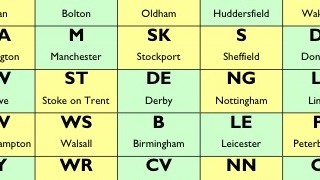
You should take a look at a website called www.motorwaymap.co.uk for an elaborate diagram of Great Britain’s motorways, along the lines of post #75 on this blog, showing a streamlined […]
When the invasion comes, head for the mountains. Sorry, flatlanders!
An updated version of the famous United States of Canada vs. Jesusland map (see posting #3 on this blog). That map represented the outcome of the US presidential election in […]
This blog has been up since September 2006. In that half year, I’ve posted 90 maps, gotten about 1.000 comments – most of them interesting and/or favourable – and just […]
n n n n n At the beginning of the twentieth century, the Ottoman Empire was called the ‘Sick Man of Europe’ because it didn’t seem able to hold on to […]
n This recently unclassified, formerly top secret document released by the Russian State Archives illustrates (quite literally) the lengths the Soviets wanted to go to in order to win the Cold War: not […]
n This brilliant map is in a gang of one, for the time being – gastronomic cartography. An intriguing category nonetheless: La France des pains (‘The France of Breads’) visually […]
n Jack Kerouac was born in Lowell (MA) Jean-Louis Lebris de Kerouac, and in spite of his fancy name, his French-Canadian parents had to emigrate to Massachusetts to find work. […]
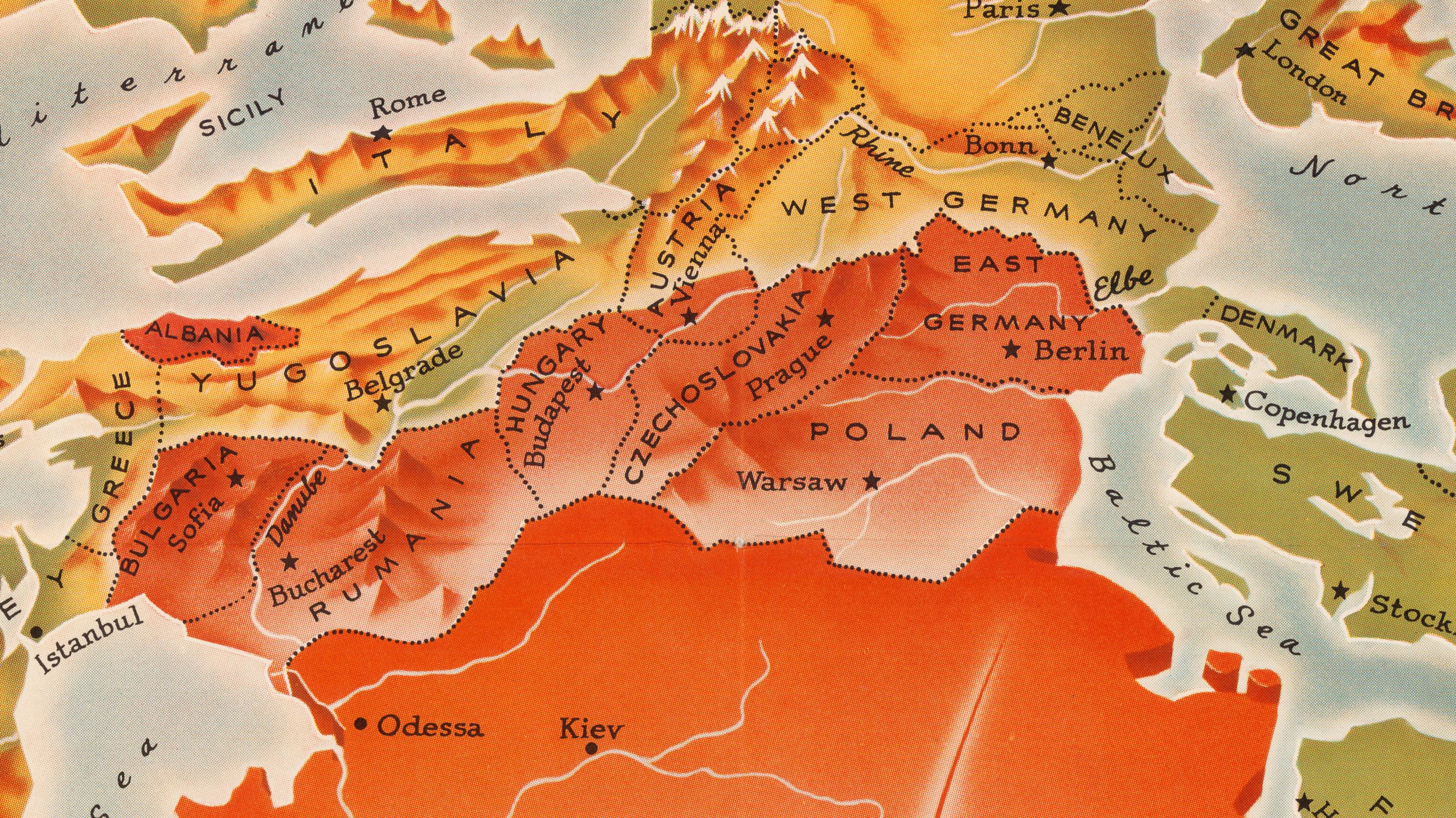
n n On August 13, 1961, the East German authorities erected a physical barrier in Berlin to prevent their citizens from ‘voting with their’ feet – i.e. fleeing to West […]
n Richard Edes Harrison trained as an architect, but became known as an illustrator for Time (from 1932 onwards) and other national news magazines. His specialty was cartography, applying unusual […]
n … then “Jupiter would be revoking democracy in Russia, Saturn would be curling in Canada, Uranus would be trying to figure out how to speak Kalaallisut, Neptune would be […]
n Not much info on this, the third (*) of former West Berlin’s ten tiny enclaves within former East Germany. This website on Berlin exclaves merely mentions that Laßzinswiesen “was […]
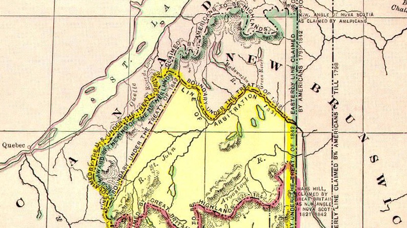
The ‘bloodless’ Aroostook War is variously said to have cost the life of a cow, a pig, or a single U.S. private.
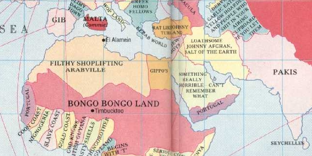
For me, this might be the original strange map. When I was a kid, I had the Spitting Image book that contained this map. I spent hours (well… whole quarters of hours) […]
Your antipodes most likely have fins rather than feet
A tilt in the usual orientation shows Moscow in a much more threatening perspective
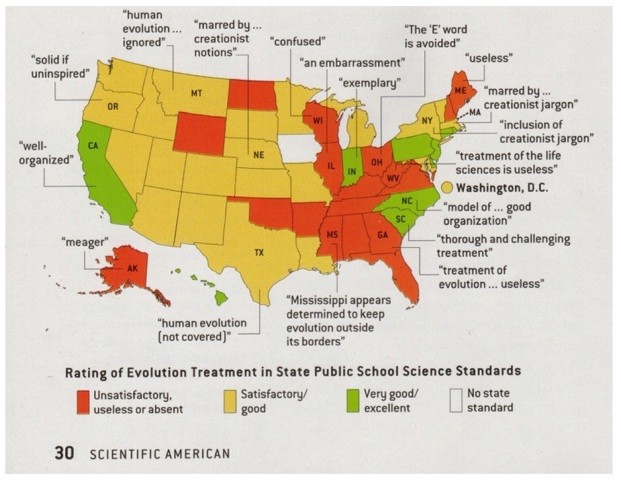
This map is drawn up by a proponent of evolution, as can be deduced from the remarks on the map and even its colours (green is good, red is bad).
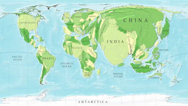
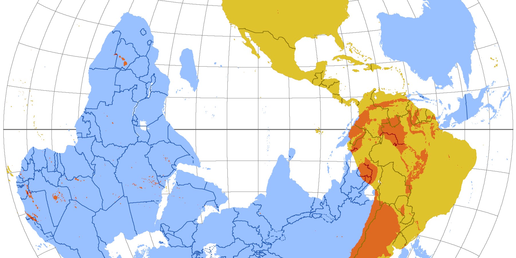
This map is part of a series of cartograms in which the actual geography is distorted in order to demonstrate information about the countries shown. In this case, the point […]
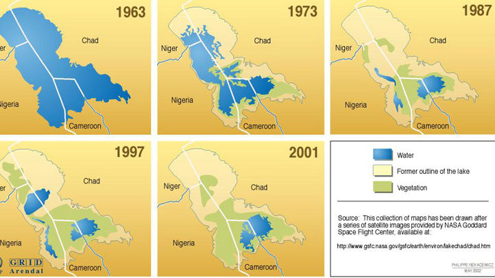
A series of maps detail the rapid disappearance of Lake Chad in Africa.
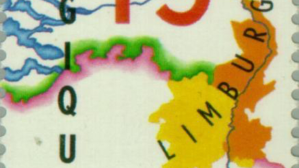
The Treaty of London gave the eastern half to the Netherlands, creating its curious southern panhandle
Ever since it achieved unification in 1871, Germany craved colonies as a matter of national pride. But by the late nineteenth century, most of the ‘uncivilised world’ was already carved […]
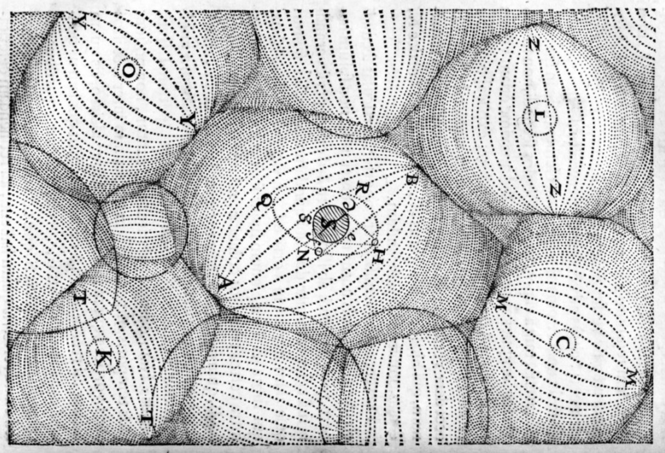
n n This map, made by Mahmud Kashgari bin Husayn bin Muhammad, was included in his Divanu Lügat-it-Türk, a scientific work he published in 1072 (AD) for the benefit of […]
n Gulliver’s Travels (1726) is a satire of contemporary England dressed up as a faux traveller’s tale by Jonathan Swift, narrating in the first person the voyages of one Lemuel […]