A geography column on history and society.
Even if you’re no fan of the New Deal, you would have to agree it was kind of a big deal. It profoundly reshaped the United States, not just institutionally but also — as this map shows — physically. Each dot represents the tangible heritage of a New Deal project: a building, a mural, a park, and more.
The birth of Big Government
“New Deal” is the catch-all term for the reforms and programs implemented from 1933 by President Franklin D. Roosevelt to counter the devastating effects of the Great Depression. Before the New Deal, the federal government was small and interested mainly in regulating commerce. After, there was Big Government — but also Social Security.
That transition was motivated by the misery of 1930s America, with millions out of work, in poverty, and going hungry. The central tenet of the New Deal was that the federal government could, and should, take action to improve the lot of its citizens.
Hence, for example, the National Labor Relations Act (NLRA), which gave workers the right to engage in collective bargaining and to strike; the Fair Labor Standards Act (FLSA), setting a minimum wage and a limit on working hours; and crucially the Social Security Act, which established a federal framework for pensions and unemployment benefits.
Unemployment relief for 15 million people
By 1938, the federal government had spent $8.5 billion (about $175 billion in today’s money) on unemployment relief, helping about 15 million people.
The federal government also became an active player on the labor market itself, via programs like the Works Progress Administration (WPA), which provided jobs for large numbers of unemployed Americans, or the Civilian Conservation Corps (CCC), which funded conservation projects on public lands. It even became a patron of the arts via the Federal Art Project, Federal Writers Project, and Federal Theater Project.
The WPA alone created 8.5 million jobs and produced more than 650,000 miles of roads; 125,000 public buildings; 75,000 bridges; and 8,000 parks. As a result, the New Deal has left a lasting imprint on America’s landscape.
More than 100 sites in every state
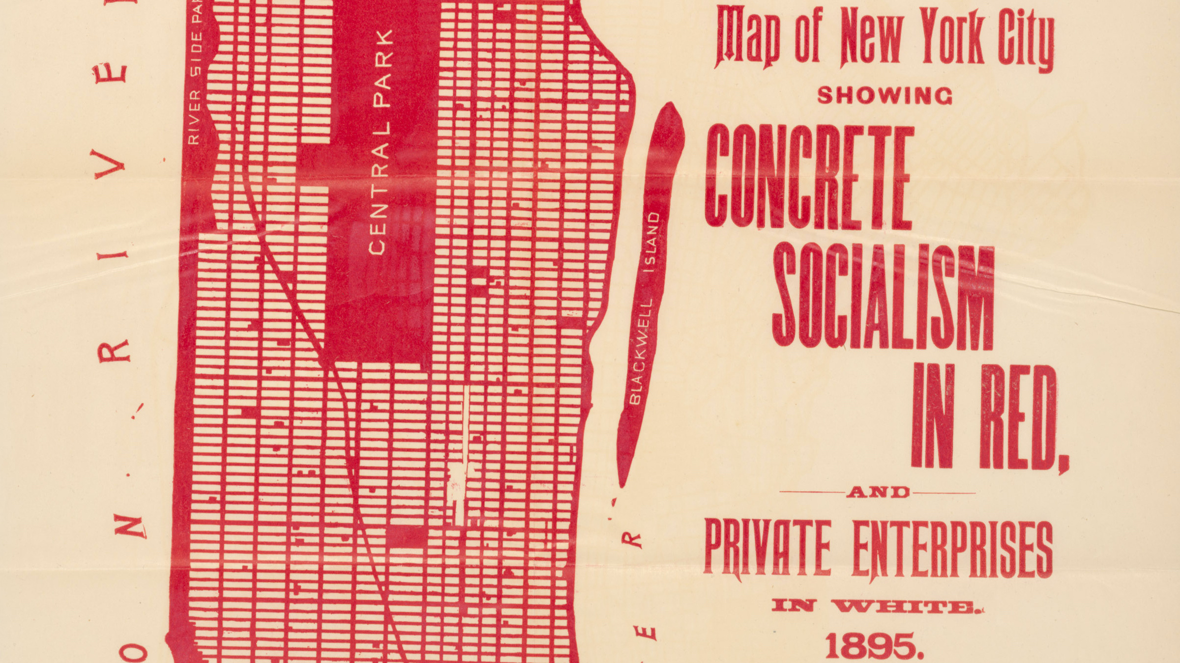
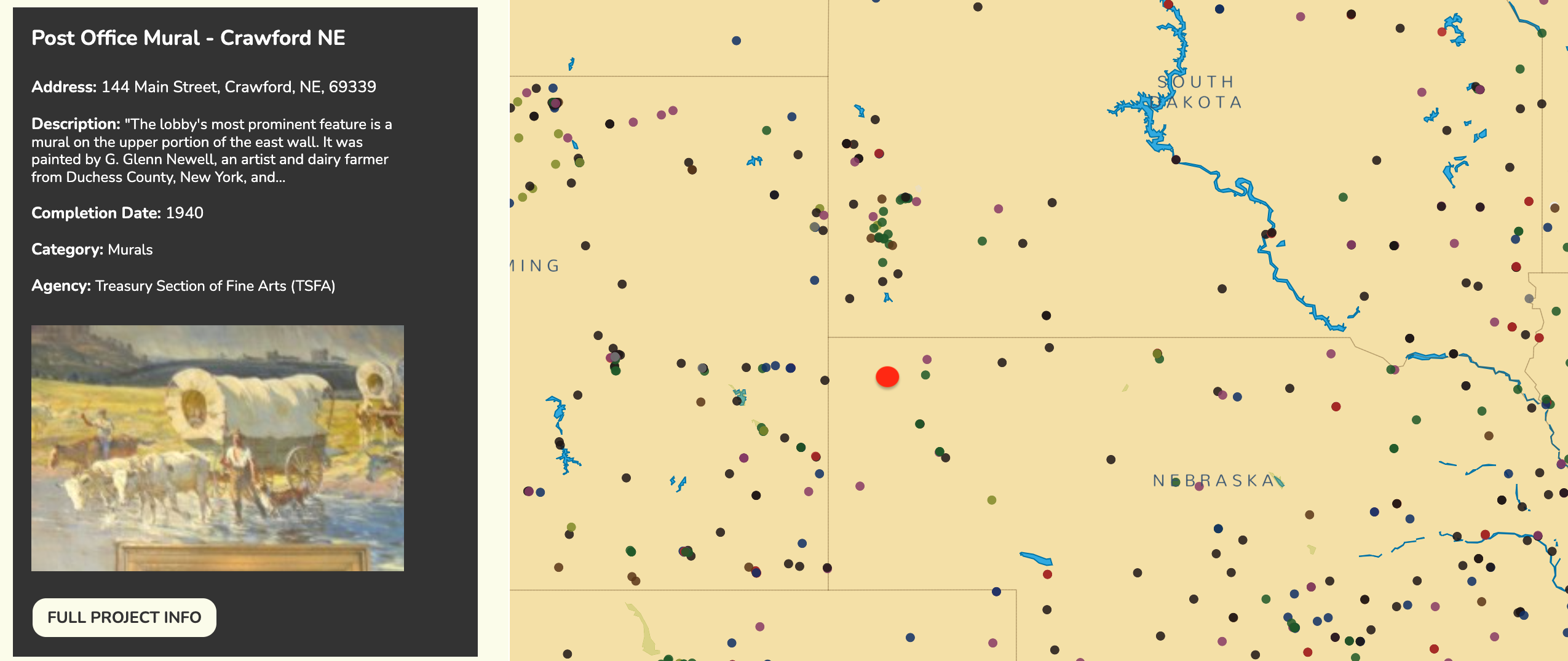
This map is one of the features of Living New Deal, an online project that researches, presents, and educates about the New Deal and its effects. The project has documented close to 18,000 New Deal sites, with more than 100 sites in every state. You can buy special guides for New Deal sites in New York City (see map at bottom), Washington DC, and San Francisco. Or you can just browse them using the online map.

Some of the biggest and most famous examples of New Deal projects include the Hoover Dam (on the border between Nevada and Arizona), LaGuardia Airport (which opened in 1939 as New York Municipal Airport), and the Bay Bridge (connecting San Francisco and Oakland).

But click further, and you’ll come across such (relatively) minor achievements as:
- South Valley Regional Airport in West Jordan, Utah. WPA crews completed this airport in 1942, initially known as the Salt Lake City Municipal Airport II.
- Buttermilk Hollow Road in Pittsburgh. The Public Works Administration provided a $299,852 grant for the project, whose total cost was $475,186. It was completed in 1936.
- Minetta Green in New York City. A park built c. 1935 with the help of the New Deal. The exact agency involved in funding or completing the work is unknown.
- A post office mural in Crawford, Nebraska. The lobby’s most prominent feature is a mural on the upper portion of the east wall. It was completed in 1936 by G. Glenn Newell, an artist and dairy farmer from Duchess County, NY.
The S word
What unites many of the monuments, large and small, famous and obscure, is a recognizable architectural style, dubbed PWA Moderne. Also known as “stripped classicism,” it borrowed heavily from the French aesthetic traditions of Art Deco and Beaux-Arts. It’s the reason many dams, bridges, museums, civic centers, courthouses, libraries, public schools, train stations, and post offices built in the U.S. between 1933 and 1944 look alike.
As for its more intangible heritage, here’s what H.G. Wells had to say about the New Deal:
“It is plainly an attempt to achieve a working socialism and avert a social collapse in America; it is extraordinarily parallel to the successive ‘policies’ and ‘Plans’ of the Russian experiment. Americans shirk the word ‘socialism,’ but what else can one call it?”

Strange Maps #1191
Got a strange map? Let me know at [email protected].

The Power of Play