East Coast quakes are felt farther than West Coast ones. Here’s why.
Earthquakes in New York are even rarer than snowfall in Los Angeles. The one that struck the East Coast last Friday was one of the largest in the region in a century. And yet on the grand scale of things — no longer the Richter scale, by the way, but the Moment Magnitude Scale — it was relatively minor, with a magnitude of 4.8. The MMS is exponential: A 5.0-magnitude quake is the equivalent of 475 tons of TNT exploding, while 6.0 equals 15,000 tons, and 7.0 is 475,000 tons.
While this quake and its aftershocks left people and buildings rattled, nobody was hurt and no serious damage was reported. Even so, the main tremor was felt from Washington DC up to Maine, according to the US Geological Service (USGS).
In California, where quakes are more common and often more powerful, they are generally felt over a much smaller area, and that’s not because West Coasters are more jaded about seismic activity. These maps clarify the difference.
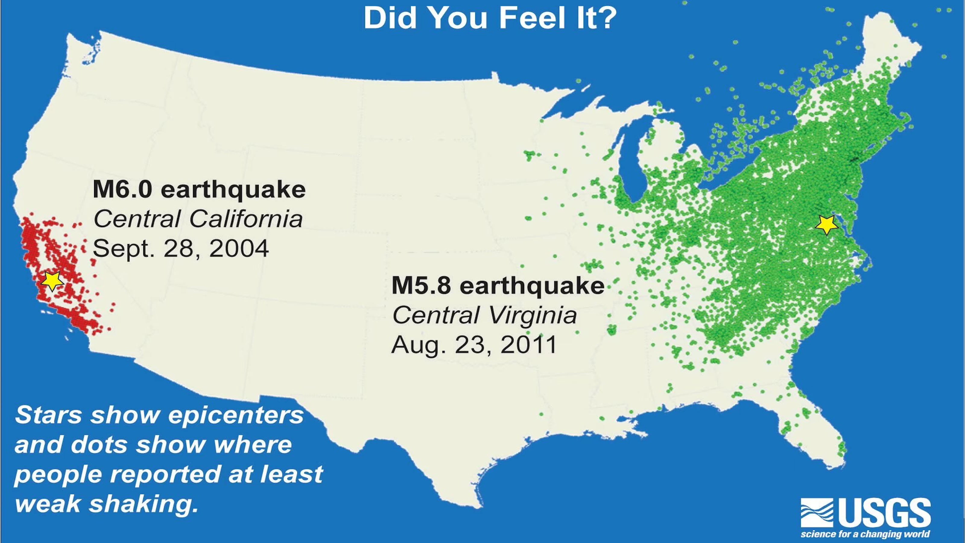
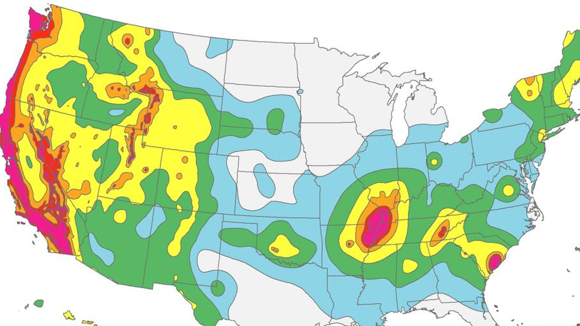
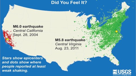
The top one shows the epicenters of two major quakes earlier this century (one on each coast) and the areas where people reported at least weak shaking. The Californian quake in 2004 had a magnitude of 6.0, meaning it released twice as much energy as the 5.8-magnitude quake that struck Virginia in 2011. And yet the 2004 quake was felt no farther than 250 miles from its epicenter in central California.
The 2011 quake, however, was felt up to 600 miles away — throughout the Mid-Atlantic states and the Northwest, all the way up in Canada, and as far west as Minneapolis and as far south as Miami.

A second USGS map shows a different quake in California (2014, but also 6.0) with a similarly small impact area. It adds two more quakes: a relatively strong one (5.8) with its epicenter in Oklahoma, and a much weaker one (4.1) in Delaware. Even this much milder tremor — remember, the scale is exponential — was felt across an area roughly comparable in size to the Napa quake.
The reason? The rocky underground east of the Rocky Mountains is generally hundreds of millions of years older than the subterranean formations east of that range. Being older means that those rocks are harder and denser, and the older fault lines have had more time to heal.
All of that means that seismic waves travel much more easily across the eastern U.S. The reverse is the case in the West, where the much younger faults absorb more of the seismic wave energy, which, as a result, doesn’t spread as efficiently as it does in the East.
This not only explains why a California quake is felt in a much smaller area but also why, unfortunately, this more focused type of quake often causes much more damage.
Strange Maps #1238
Got a strange map? Let me know at [email protected].
Follow Strange Maps on Twitter and Facebook.