Solved: the mystery of Brazil’s time-traveling capital city
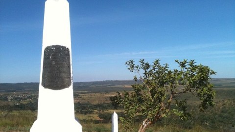
Image source: Nevinho, CC BY-SA 3.0
- Why does Brasilia, built in the 1950s, pop up on a 1920s map of South America?
- We put the question out there, and the answers — some more credible than others — came flooding back.
- Thank you, internet hive mind: you’ve solved a cartographic mystery!
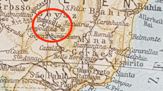
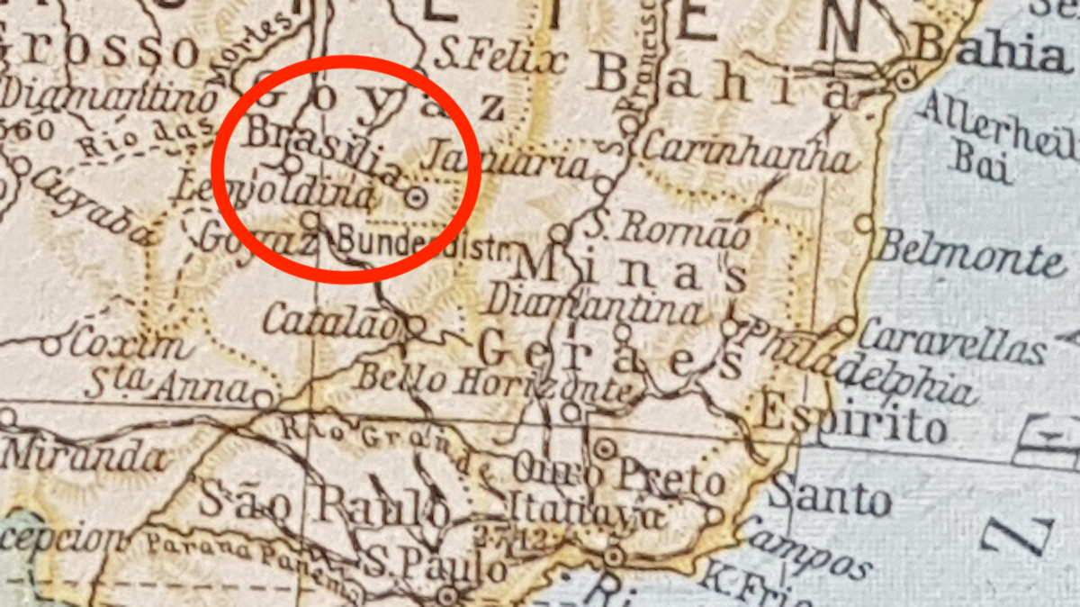
1920s map of South America, showing Brasilia, which was built only in the 1950s.
Image source: Rob Cornelissen
Cartographic mystery
Last week, we reported on a cartographic mystery that had us baffled: a map of South America, dateable to the 1920s, showing Brasilia — even though work on Brazil’s planned capital only started in 1956. Short of plausible answers, we asked you. And fortunately, you’re cleverer than us.
The answers fall into two categories:
- The map dates from the 1950s (or thereafter), which explains why Brasilia is on the map. But there are good reasons why the map appears much older.
- The map does date from the 1920s (or thereabouts), but there are good reasons for Brasilia to already be on the map.

Neuer Sammel-Atlas, published by the Berliner Morgenpost in 1957, showing Germany’s pre-1938 borders.
Image source: Norbert Adam
Outdated borders
Let’s explore option one first. For starters, the inclusion of Weimar Germany (as a size comparison) in itself is not enough to conclusively link the map to the 1920s. West Germany didn’t formally accept the Oder-Neisse border (i.e. the eastern border of East Germany with Poland) until 1990, so many West German maps continued to show the 1919–37 border well into the 1980s.
So, if we imagine that the map is post 1956, that would explain why Brasilia is on it. But why the outdated borders throughout South America?
Theory one: the map is meant as a contemporary map, hence the inclusion of Brasilia, but it uses a much older base map, hence the older borders. Reasons? The publisher was lazy or dishonest; newer material was not available or too expensive. Here is a well-crafted story that merits inclusion in its entirety:
“The map was produced after 1960, as a partial update or re-release of an atlas from the 1920s. Perhaps the ‘nostalgia’ of an older map was a feature, for instance for a coffee-table book. When the intern tasked with preparing the map did a quick skim for major changes or errors, they simply checked for the presence of all the capital cities. Seeing that Brazil’s capital was missing, they added it to the map, and sent it off for printing.”

Is there something ‘off’ about the curvature and typeface of ‘Brasilia’?
Image source: Rob Cornelissen
Suspicious curves
I can smell the ink and hear the roar of the presses, can’t you? Some convincing-sounding clues for this theory:
- Rio is written in the heavy sans-serif typeface as the other capital cities, suggesting it is indeed still the capital of Brazil.
- The curvature of “Brasilia” is suspicious: it looks like it was added later.
- Compared to other names on the map, the typeface of both “Brasilia” and “Bundesdistr” is a bit off.
Theory two: the map was an experiment, for scholarly or artistic reasons, to recreate a map of South America as it was in the 1920s — but the mapmakers forgot to erase Brasilia. Thus unwittingly leaving a temporal anomaly on the map for us to wonder over.

A view of Copacabana Beach in Rio de Janeiro in the 1940s, when Rio de Janeiro was still Brazil’s capital.
Image source: Werner Haberkorn / public domain
Beach Capital
However, the majority of opinion — and the weight of historical evidence — points to the second option: the map does date from the 1920s, and there are good reasons for Brasilia to be where it is. Even though at that time Rio was still the nation’s capital, and the area now occupied by Brasilia nothing but wilderness.
Many countries throughout history have planned and constructed new capitals for themselves — from ancient Egypt (Akhetaten, 1346 BCE) to, most recently, the Pacific island nation of Palau (Ngerulmud, 2006). Brazil might be unique in the time it took the nation to build the darn thing. More than a century elapsed between the first mention of Brasilia and its inauguration as the country’s new capital. Here’s a thumbnail overview:
- In 1763, Rio de Janeiro became the capital of Brazil, then still a Portuguese colony. But already then, tentative suggestions were made to move the capital inland, as a safeguard against seaborne invasion (the British and Dutch being the most likely candidates).

Don Bosco had a vision of a city where Brasilia is now. Here, the Don Bosco Sanctuary in Brasilia.
Image source: Claudio Ruiz; CC BY-SA 2.0
Bosco’s vision
- In 1813, Hipólito José da Costa — the ‘”Father of the Brazilian Press” — wrote a number of articles suggesting the capital be moved inland, “next to the river rapids that flow north, south and northeast.”
- In the 1823, José Bonifácio, one of the “patriarchs” of Brazilian independence, first proposed “Brasilia” as the name for the planned inland city. His other suggestion was “Petropolis,” after Emperor Pedro I of the newly-independent country. Bonifácio’s proposal to the General Assembly came to nothing when the emperor dissolved parliament.
- In 1883, according to legend, Don Bosco — the founder of the Salesian order and later sanctified — had a dream in which he foresaw a futuristic city at a location corresponding to that of Brasilia. The legend was eagerly adopted by promotors of the inland capital project. There are references to Bosco throughout Brasilia, and a city parish bears his name.

The Future Federal District, as shown on a 1913 railway map of Brazil.
Image source: Library of Congress
Quadrilatero Cruls
- In 1891, Article 3 of Brazil’s first republican constitution stated that “an area of 14,400 square km in the Central Plateau of the Republic is reserved for the Union, and will be demarcated at another opportunity, in order to establish a Future Federal Capital.”
- In 1892–3, an expedition led by the Belgian-born astronomer Louis Cruls demarcated an area as prescribed by the constitution, in a perfect rectangle. The “Quadrilátero Cruls” became synonymous with the “Future Federal District” and appeared on maps under either name.

The foundation stone for Brazil’s future capital was inaugurated in 1922.
Image: Nevinho, CC BY-SA 3.0
Foundation stone
- On 18 January 1922, President Epitácio Pessoa of Brazil issued Decree 4494, setting aside an area in the east of the state of Goiás for the future federal capital of Brazil.
- At noon on 7 September 1922 — exactly 100 years after Brazil’s independence — a foundation stone (“Pedra Fundamental”) for the new capital was inaugurated at what is now known as Morro do Centenario, (“Centennial Hill”) on the Serra da Independência, nine km from the town of Planaltina.
- The memorial obelisk is engraved as “the Foundation Stone of the Future Capital of the United States of Brazil,” but doesn’t mention any name for the city. After decades of planning, it was the first actual construction on the site. However, the project stalled for another 34 years.

Brasilia today: a metropolis of four million.
Image: Agência Brasil, CC BY-SA 3.0
Made in Brazil
- In January 1956, straight after his election as president, Juscelino Kubitschek, started with the construction of the capital. He was not only finally fulfilling Article 3 from the 1891 constitution, but also one of his campaign promises. Brasilia would be built about 30 km from the Pedra Fundamental. The remarkable speed in which it was finished is due in no small part to all the planning that had gone before.
- On 21 April 1960, Brasilia was officially proclaimed a city, and the nation’s capital. Government officials and foreign ambassadors visiting the city created its first traffic jam. At the time of its inauguration, Brasilia had around 100,000 inhabitants. Today, the agglomeration counts over 4 million inhabitants.
It is very likely that the map dates from 1922 or shortly thereafter, when it seemed — for a short while — that the project for Brasilia would finally be taking off. A further indication of this is that the Federal District included on the map is the perfect quadrangle measured by Cruls (and still current at the time), and not the smaller, asymmetric FD as was delineated in the 1950s.
Including the new capital may have been a way to “future-proof” the map — but it ultimately goes to show that mapmakers should stick to the facts on the ground. As a result of their miscalculation, Brasilia on the 1920s map turned out to be, as one reader suggested, “the biggest paper town ever.”
Many thanks to all who have contributed to this article: Vinicius Alvim, Mark Binder, Jack Bolivar, Renke Brausse, Eduardo Cabral, Silvana Camboim, Gregory J. Casteel, Antinia Constantin, Estevao Correa, Pierre des Courties, Tony Cox, Logan Ferree, Peter Forster, Ariel Gadia, Paolo Gangemi, Pedro Garcia, Kiko Gatto, James Gillespie, Andrew Guthrie, Heinrich Hall, Harrison Jr., Graham Haynes, Robin Hood, Iwaninho, Sabine J., PJ Jaudouin, Yuri Lacerda, Pedro Leite, Sam Ley, Pablo Lia Fook, Lorenzo Luisi, Daniel Lundberg, Terry McBride, Gabriela Miller, Karoline Muller Reis, Ramiro Miranda, Moonleaf, Simon Newby, Alessandro Nicoli de Mattos, Carlos Pheysey, John Reinert Nash, José Luis Orizales, Tim Robinson, Filipe Santiago, Kári Tulinius, Gary Vellenzer, Maarten Vidal, Joseph West, Rick Westera, Thomas Wigley and Karl Friedrich Winter. My apologies if I’ve forgotten anyone.
Strange Maps #990
Got a strange map? Let me know at [email protected].