Does Tristan da Cunha have the world’s weirdest place names?
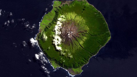
Image: NASA ASTER Volcano Archive, JPL
- Tristan da Cunha is the world’s most isolated inhabited island.
- It also has some of the world’s weirdest place names.
- Is there a link? Maybe, if we stretch Darwin’s theory from biology to topography.

Bird’s eye view on Edinburgh of the Seven Seas, the capital of Tristan da Cunha.
Image: The Official CTBTO Photostream, CC BY 2.0
Thriving in isolation
As Darwin predicted, islands have more species. That’s because isolation can help preserve biodiversity. Could it be that place names also thrive on islands, and for the same reason?
Tristan da Cunha certainly seems to offer excellent support for that theory. Located roughly halfway between South Africa and Uruguay, the tiny, volcanic island is the most isolated inhabited place on the planet. It’s only reachable by ship, sailing about 10 times a year from Cape Town.
The British island in the South Atlantic also boasts some of the world’s weirdest toponyms. Since there are only about 250 Tristanites on the island, that means the island must have the highest weird-place-name-per-capita ratio in the world.
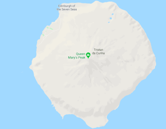
Almost-blank map of Tristan da Cunha.
Image: Google Maps
Almost blank
But it’s not easy to sample Tristan da Cunha’s toponymic delights, at least not on Google Maps. All you’ll find are a pin for Queen Mary’s Peak, the usually dormant volcano rising at the island’s center; and the label for the island’s capital, and indeed only settlement, delightfully named ‘Edinburgh of the Seven Seas’. (Although the locals just refer to it as ‘the settlement’).
Zooming in further will reveal two churches (St Mary’s, Anglican; and St Joseph’s, Catholic), one cemetery, one bar (The Albatross), one shop, and a small museum called the Thatched House. All of which is squeezed in between the harbor and a lava field, and connected by the island’s only road, somewhat ambitiously called the M1. No street view. No other place names.
I think we need to talk about Tristan da Cunha’s place names. pic.twitter.com/2H5PMmcZfc
— Dan Snow (@thehistoryguy) January 25, 2020
Local weirdness
Coming across a more detailed map of the island, British historian Dan Snow was taken aback by some of the local weirdness. He poured his findings into a Twitter thread titled We need to talk about Tristan da Cunha’s place names. Here’s what you won’t find on Google Maps.

Mary and Olav, together forever on Tristan.
Image: Dan Snow (Twitter @thehistoryguy)
Mount Minor Royal
Conventional Mt minor royal. So far so good, Mr Snow starts. Queen Mary’s Peak (2,062 m, 6,765 ft) was named after Mary of Teck (1867-1953), the wife of King George V (r. 1910-1936). Just south is Mount Olav (1,969 m, 6,460 ft), named after Olav V, king of Norway (r. 1957-1991). Intriguing though: both are fairly recent royals, so the mountains must have been named rather late. More on that in a minute.

‘Big Green Hill’, really?
Image: Dan Snow (Twitter @thehistoryguy)
‘Flat’ names
As remarkable as some toponyms on Tristan are, many others are remarkably ‘flat’ – merely descriptive, in the most generic way possible. Mr. Snow zooms in on Big Point, in between Little Beach and Big Beach, and shows Big Green Hill just to the south – although the place in between, Pig Bite, can’t but stimulate the reader’s curiosity.

The island’s capital is its only settlement. Nothing much to do there. Pretty name, though.
Image: Dan Snow (Twitter @thehistoryguy)
Best capital name in the world
That would have been enough mappery for most, but Mr. Snow is reeled in by the settlement’s name. Best capital name in the world. By far, he proclaims.

Tristan da Cunha’s east coast is weird name central.
Image: Dan Snow (Twitter @thehistoryguy)
Trump level crazy
Looking further east, here are the two killer toponyms that cement Tristan’s reputation as the capital of weird place names:
- Ridge-where-the-goat-jump-off, and
- Down-where-the-minister-land(ed)-his-things
These two ultra-descriptive place names are apparently used in full by the locals. They actually do roll off the tongue quite well.
So how, when and – most of all – why did those names come to be associated with places on Tristan? Incredibly, Mr. Snow’s thread elicited a response from the grandson of the man who surveyed those names.

Caption for this map from Allan Crawford’s memoir: “Tristan da Cunha as surveyed by Allan Crawford in 1937-8. The place names were collected from islanders who helped with the survey; no deliberate names had ever been given to places; they were either natural descriptions such as Stony Beach, or they recalled events – Anchorstock was the spot where the wooden stock of an anchor was once washed ashore.”
Image: Bryant Crawford (Twitter @BryantCrawford)
“A meaningful chart”
Blame my grandfather for using the real, day-to-day names the islanders used when he mapped it, wrote Bryant Crawford. Mr. Crawford (Jr.) published a few excerpts from ‘North, South, East & West’, his grandad Allan B. Crawford’s memoirs, which reveal the special link between Tristan and Queen Mary, and why the heck the minister landed his things on that particular beach.
“When I landed on Tristan Island for the first time in 1937, as the Surveyor of the Norwegian Scientific Exhibition, I noticed that not many of the names on the Admiralty chart corresponded with the names used by the local islander population. It was at once evident that I should record the actual names used by the inhabitants for all topographical features in order to produce a meaningful chart.”
Loyal to the Royals
“I was impressed by the islanders’ loyalty towards the Royal Family, for many of the island cottages displayed their photographs, especially King George V and his consort. In fact, Queen Mary had taken a great interest in the islanders’ welfare and had presented the community with a harmonium for their Church.”
“In 1906, when Rev. and Mrs. Barrow arrived for a three-year chaplaincy, the weather was too rough to land at the Settlement, so they chose a beach landing in the lee. To this day, the beach is still known as ‘Down where the minister land his things’. It is because the name goes with a swing that it is still in general use.”
“There is already a Goat Ridge on the west side of the village, so a ridge on the south of the island is known as the ‘Ridge-where-the-goat-jump-off’, the sentence being used ungrammatically in full (they seldom used the past tense in speech).”
In all, Mr. Crawford noted down about 80 new toponyms for the island. A few (Hottentot Point, East Jew’s Point, West Jew’s Point) would today be considered insensitive – showing how much time has elapsed since the 1930s.

German research vessel Maria S. Merian, just off Edinburgh of the Seven Seas.
Image: Mison, CC BY-SA 3.0
On and off the map
Some of Tristan’s other more notable place names:
- Not on this map: The Hill-with-a-cone-in-it-on-the-east-side-of-the-gulch-come-down-by-the-Ridge-where-the-goat-jump-off.
- Blineye: a crater where a bullock was injured in one eye (‘Blideye’). and hid afterwards. The area was earlier called ‘Ridge-where-the-Blindeye-stop’.
- Bugsby Hole: asteep mountain slope, possibly a reference to a Bugsby Hole in London’s East End).
- Frank’s Hill: a crater where Frank Monk, a Belgian castaway from the American bark Mabel Clark was overtaken by night in 1878.
- Nellie’s Hump is a secondary crater of the main volcano. Its name commemorates a dog chasing a goat.
- Pigbite, finally, is a ridge where over a century ago a pig chased and bit one of the islanders.

The Shetland and Orkney Islands also have their fair share of topographic weirdness.
Image: Mapfodder
It’s a long way to Fografiddle
But Tristan is not the only island with weird place names. A few years ago, Strange Maps zoomed in on the strange place names of Scotland’s Shetland and Orkney Islands.
On second thought, we may have overstepped the mark by handing the weird place name World Cup to Tristan da Cunha. Those two Scottish archipelagoes are quite far out too. But the same observation holds: strange place names seem to thrive in isolation. We’re lucky to have Mr. Crawford’s first-person account of their genesis on Tristan. How cool would it be to find a Viking scroll describing how the Orkney and Shetland Islands were named…
Strange Maps #1010
Got a strange map? Let me know at[email protected].

