End gerrymandering? Here’s a radical solution
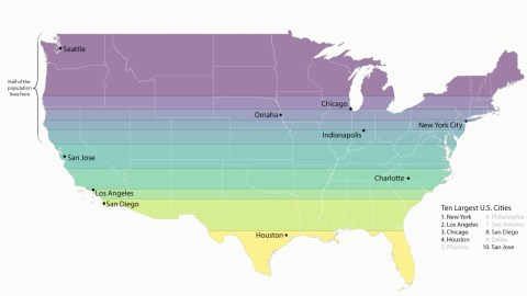
Image: u/curiouskip, reproduced with kind permission.
- Slicing up the country in 10 strips of equal population produces two bizarre maps.
- Seattle is the biggest city in the emptiest longitudinal band, San Antonio rules the largest north-south slice.
- Curiously, six cities are the ‘capitals’ of both their horizontal and vertical deciles.

The original cartoon of the ‘Gerry-Mander’, published in 1812 in the Boston Centinel.Image: Elkanah Tisdale (1771-1835), Public Domain.
One way for a political party to manipulate the outcome of elections is to ‘gerrymander’ electoral districts: manipulate their boundaries to increase the likelihood of a favorable outcome (see also #53).
The term is almost as old as the United States itself, and the practice continues to disfigure the electoral map to this day. Perhaps these maps can serve as the inspiration for a radical solution.
They show the contiguous United States (i.e. without Alaska and Hawaii) sliced latitudinally and longitudinally into ten straight-bordered bands of varying size, so that each contains exactly 10 percent of the population.
Although certainly not intended as a reflection on electoral redistricting, it’s tempting to see these sweeping re-alignments of the U.S. as a suggestion with some potential in that direction.
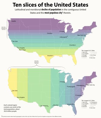
The contiguous United States, divided into horizontal and vertical deciles. Image: u/curiouskip, reproduced with kind permission.
Reddit user curiouskip used U.S. Census population data to divide the ‘Lower 48’ into deciles (ten equal parts), each representing about 30.8 million people. Each decile is consigned its most populous city as ‘capital’.
Looking at the top map, which divides the U.S. into 10 longitudinal strips, we see
- Seattle rules the northernmost slice of territory. It is the broadest, and therefore also the emptiest one.
- The Chicago, Omaha, New York City and Indianapolis strips complete the northern half of the country. And indeed: 50 percent of the population occupies roughly one half of the country, from north to south.
- The dividing line between the top and bottom halves of the country runs from just north of the San Francisco Bay to halfway across the Delmarva Peninsula.
- Capital cities of the southern strips are San Jose, Charlotte, Los Angeles, San Diego, and Houston.
- The Houston Strip is divided into two non-contiguous areas. Florida maintains its panhandle, albeit much reduced.
The bottom map shows the U.S. divided latitudinally into 10 bands of equal population.
- San Jose and Los Angeles both retain their capital status, this time of the two westernmost strips.
- San Antonio is the main city of the Big Empty, more than twice as wide as the second-broadest band.
- The dividing line between America’s eastern and western half, population-wise, is far off-center: it skirts the eastern edge of Chicago, making the western half much bigger than the eastern one.
- Houston, Chicago, and Indianapolis also remain the largest cities in their respective bands.
- Further east, Jacksonville and Philadelphia get to rule over their strip of America, while Charlotte and New York City keep winning, both vertically and horizontally.
Redistricting a country into zones of equal population – and that being your only criterium – will create districts that are randomly diverse, and perhaps also, at least in this case, unmanageably large.
However, mixing up the political map with a bunch of straight lines as the only instrument is something that has been considered before. Usually, the objective is the wholesale removal of age-old divisions.

France divided into 80-odd geometrical departments: failed proposal by Jacques-Guillaume Thouret (1790).
Image: Centre historique des Archives nationales – Atelier de photographie; public domain.
In 1790, the French revolutionary Jacques-Guillaume Thouret proposed doing away with France’s old provinces by replacing them with about 80 perfectly square departments. The plan lost its main proponent when Thouret lost his head during the Reign of Terror in 1794 (see also #159).

In this rather outlandish proposal, continental Europe’s 24 cantons center on Vienna.
Image: PJ Mode Collection of Persuasive Maps, Cornell University.
And in 1920, an anonymous author – possibly the Austrian P.A. Maas – proposed slicing up Post-World-War-I Europe as a pie, into 24 slices that would center on Vienna’s St. Stephen’s Cathedral. Each of those slices would be made up of a wide and random variety of linguistic, ethnic, and religious groups – and that would be the point: the better to unite them all into one massive superstate (see also #851).
Needless to say, both plans never left the drawing board. Would a proposal for the longitudinal and/or latitudinal redistricting of the U.S. have more traction?

Putting the ‘connect’ into Connecticut: the Nutmeg State extending from the Pacific to the Atlantic. Image: Connecticuthistory.org
Well, for one, coast-to-coast polities have some pedigree in America’s past: some of the first colonies had claims that extended from the Atlantic all the way to the Pacific.
If history had gone entirely the way Connecticut would have wanted, the state would include such inland cities as Detroit, Chicago, and Salt Lake City, and extended to what is now the northern part of California.
Is such geopolitical weirdness reasonable or feasible today? Absolutely not. But in its randomness, would it be it as unfair as gerrymandering?
Decile maps of the contiguous United States reproduced with kind permission by u/curiouskip; found here on Reddit.
Strange Maps #1054
Got a strange map? Let me know at [email protected].
