Which alt-fuel is right for you? That depends on where you live
- The future of mobility isn’t just going to be all-electric. So, which fuel to pick?
- None of the alternatives is as ubiquitous as gas (or diesel), so location matters.
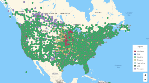
- The point is illustrated by these maps, which show the remarkable regional variation of alt-fuels.

Here’s the thing about getting rid of the combustion engine: We’re not switching from one system to another, but from one to many. The future of mobility isn’t going to be all-electric.
Granted, if you’re looking to replace your “classic” motorization — an internal combustion engine (ICE) running on gasoline or diesel — with an alternative fuel, the best available fit will often be an electric vehicle (EV).
But it’s not just EVs that claim to be more efficient and sustainable than ICEs. In many cases — when you’re driving longer distances or hauling heavier loads, for instance — other motorizations will be more appropriate.
There are the three gas alternatives, each with their own abbreviation (CNG, LNG, LPG), and there are ethanol and biodiesel. Each has their own set of ideal use cases, and specific pluses and minuses. And then there’s hydrogen, touted by some as a better alternative to ICEs than EVs.
Perhaps in 20 years we’ll kick ourselves for having wasted too much time and effort on the far more imperfect solution that is electric driving. But hydrogen, for now, is a very minor element in the alt-fuel mix.
Which one to pick? Your choice will have to balance cost, convenience, and environmental impact. Say what you will about burning the refined residue of dead dinos in your gas tank, but it sure is simpler than figuring out which of the alternatives works best for you (and the planet).

One piece of the puzzle is the availability of places to refuel (or recharge) your alternatively powered vehicle. It’s an important element of what mobility experts call “range anxiety”: the fear your car will run out of juice before it reaches the next filling station.
At least for EVs, that anxiety is receding, thanks both to newer models boasting wider ranges, and to the charging network getting denser by the day. Yet it’s not disappearing completely, and for good reason: In rural, sparsely populated parts of the U.S., it can still be difficult to come across a charging point when and where you need one.
That’s where the Alternative Fueling Station Locator (AFSL) comes in. Developed by the U.S. Department of Energy, this map provides a geographic overview of EV charge points, plus refueling stations for all the other alternatives, and even allows you to plot a trip from point to point.

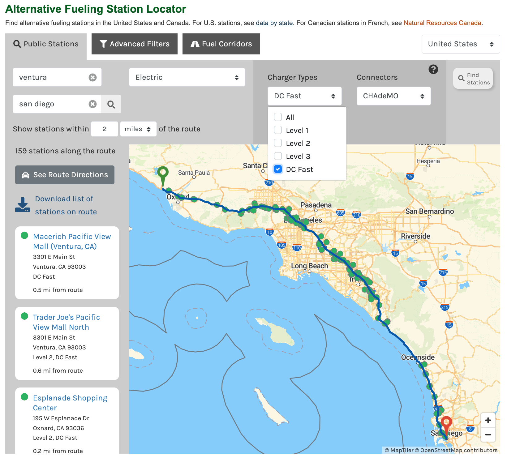
Taking your EV on a road trip from Ventura to San Diego? Just let the route calculator know how fast you want your chargers, and how far you want to drive off-route to find them. We’ve selected only the fastest stations (DC Fast), picked the relevant type of connector for our hypothetical EV (using a CHAdeMO plug), and have decided we only want to stray 2 miles from our course to find the right station.
As the map shows, there are plenty of options, except for the stretch between San Clemente and Carlsbad — so we must make sure we have enough charge to bridge those 25 miles (40 km). The list of selected charge stations can be downloaded for easy reference.
But 25 miles between charge stations: that’s nothing. Take an electric drive across some of the emptiest parts of the west – say from Omaha, Nebraska, to Helena, Montana – and you simply won’t make it, at least not on public chargers alone. You’ll find a charger about 100 miles (170 km) into your trip, at the Kum & Go (sic) in Sioux City, Iowa. After that, it’s 880 miles (1,440 km) until the next one, at Audi of Bozeman.
The AFSL’s map of EV charging stations shows there are plenty of charging opportunities on both coasts, in and near big cities, and indeed throughout most of the country. However, there is a remarkable “black hole” in the West, covering most of Montana and Wyoming, all of South Dakota, and large parts of Nebraska and North Dakota.
Similar but smaller charging deserts occur elsewhere, among others in a zone stretching from southeastern Arizona across southern New Mexico into north-central Texas, and also in an “Appalachian” zone covering most of West Virginia, stretching into eastern Kentucky.
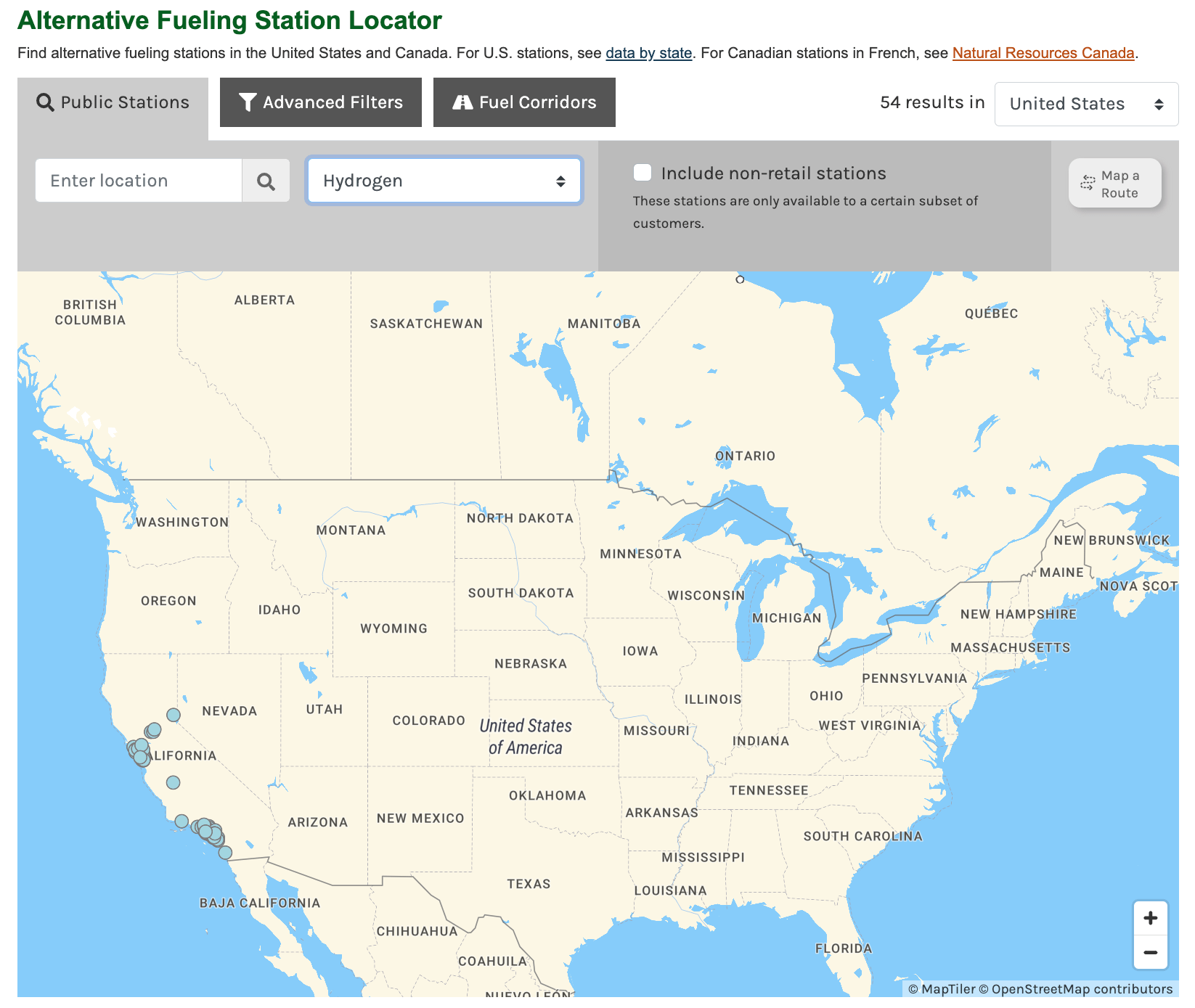
Be that as it may, the geography of the other alt-fuels is even more lopsided. The most extreme example is hydrogen. You can forget about it if you don’t live near any of the 54 public hydrogen fueling stations, all in California, and most bunched around the greater San Francisco and Los Angeles areas.
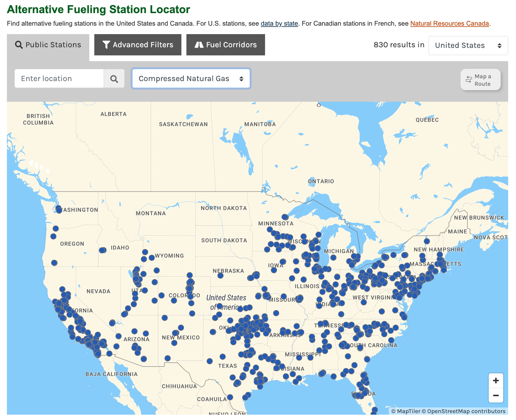
What about the three Gs? Propane (LPG) is the most widespread, with a presence in all 48 states on the map and heavy concentrations in near the big cities. Distribution is a bit spotty in some states, though, with only a handful of filling stations in some western states, and just one in upstate Maine, for example.
Distribution gets progressively spottier for CNG and LNG. There are large concentrations of LNG stations in California, in the Boston to Washington corridor, in the Midwest, and in Oklahoma. But not a single one in the Dakotas or Montana, and not much more in many of the adjacent states.
Rarest of the Gs is LNG, which is totally absent from the Northeast, and barely present in the rest of the country, barring a small cluster around Dallas in Texas, and a short corridor inland from Los Angeles in California.

The remaining to alt-fuels are additives rather than replacements. Both biodiesel and ethanol are renewable fuels made from organic material, and are blended with conventional diesel and gasoline, respectively. Obviously, they are intermediary solutions on the way to 100% sustainability and 0% emissions.
Ethanol is also known as grain alcohol. More than 94% of the ethanol produced in the U.S. is made from corn starch. More than 98% of gasoline in the U.S. has some ethanol in it. The most common blend is E10 (10% ethanol, 90% gasoline). There’s also E85, a high-level blend with 51% to 83% ethanol, depending on geography and season, for use in flex-fuel vehicles.
Biodiesel is made from vegetable oils (mainly soybeans or rapeseed), animal fats or recycled cooking oil. It is blended with conventional diesel. In the case of B20, the share of biodiesel ranges from 6% to 20%. Most biodiesels can be used by regular diesel vehicles without having to modify the engine. Blends with greater shares of biodiesel may perform worse in colder weather.

Both ethanol (E85) and biodiesel (B20) have a very specific distribution pattern, centered on the Midwest, no doubt connected to the proximity of either fuel’s main agricultural ingredients.
B20 fueling stations are concentrated heavily in Iowa and the areas immediately surrounding that state, including southern Minnesota and northern Illinois. E85 stations are spread much more widely, but still clearly anchored to the Corn Belt.

For more information on alt-fuels, check the Alternative Fuels Data Center of the Department of Energy, which also has the Alternative Fuels Station Locator (in the U.S. and/or Canada).
Strange Maps #1162
Got a strange map? Let me know at strangemaps@gmail.com.
Follow Strange Maps on Twitter and Facebook.
