Phallic Cartography 101
Warning. Some words and images in this post may unsettle readers of a tender age or disposition. If that’s you, look away. This blog does not set out to cause offence. But we go where strange maps lead us. Even if that is the field of phallic cartography, booby-trapped with innuendo. If you must point the finger, blame the Canal & River Trust. After all, they‘re the ones who published this penis-shaped map of Berkhamsted.
The Canal & River Trust is a British charity tasked with managing 2,000 miles (3,200 km) of inland waterways in England and Wales. Peddling pictures of male genitalia to the general public decidedly isn’t part of its core business. And yet there it is, sans pudeur ni morale: a village-sized schlong dressed up as a tourist map, care of the Canal & River Trust. How did this happen?

Grand Union Pecker (Image: Canal & River Trust)
The map depicts a small segment of the Grand Union Canal, at 286 miles (461 km) Britain’s longest man-made waterway, if you count all its branches. The mainline itself stretches 137 miles (220 km) from London to Birmingham, cutting through Berkhamsted, pictured on the map. This small Berkshire town to the northwest of London (near the wonderfully-named town of Tring) is not just any place on the canal: a former hub of boat-building and waterborne transport, it was (and still is) known as the Port of Berkhamsted.
It’s also one of the Trust’s ‘100 Places to Visit’, the name for its campaign to promote the bankside pleasures of Britain’s rivers and canals. That campaign is supported by cartoon-style maps pinpointing each location’s tourist highlights. The Berkhamsted map shows a genuine Canadian totem pole – one of only half a dozen on display in Britain. Marking the site of a former timber yard next to the canal, the totem pole commemorates the rescue from starvation of a local timber heir by one of the First Peoples on Vancouver Island, on Canada’s Pacific coast.
Almost half a century after its erection, the pole is one of post-industrial Berkhamsted’s quirkier attractions. The map reveals a few more: Canal Fields, Broadwater Lock, Berkhamsted Castle, and not least The Crystal Palace, The Boat and The Rising Sun: three public houses welcoming walkers and bikers to break their journey along the scenic canal path.
Despite the undisputable charms of that setup, the map’s overnight popularity on social media did not stem from its content, but from its contours. Two globular extrusions on the left and the round-tipped extrusion to the right give the Trust’s picture of Berkhamsted a decidedly penile shape – but what clinches the simile is the canal coursing through the middle, like an oversized, open-air imitation of a urinary tract.
Someone noticed. “Looks like a willy tee hee”, read the first comment on Facebook. The Berkhamsted Willy spread like wildfire on social media. Thousands shared the image, and their thoughts. One twitterer chuckled: #Berkhamsted map a bit of a cock-up, while another simply tweeted: That’s what I call a Canadian totem pole. When the BBC News website reported the story on 14 August 2014, it shot up to ‘Most Read Article’ in no time.
Speaking to The Independent (also 14 August), Trust spokesman Simon Salem sheepishly admitted that the charity only noticed the one-eyed trouser snake on its map when the media storm broke: “This is one of about 100 maps we’ve been promoting. It does look, as the poster on Facebook says, like a willy. We didn’t notice it. Somebody should have seen it, I agree. You could accuse of us of being a bit naive but canals are long, straight things, and when you draw a map it tends to be that sort of shape”.
Indeed. Yet none of the other ‘100 Places to Visit’ have been diagnosed with a similarly phallic persona. Among them must be quite a few stretches of canal that are long and straight enough. But they obviously lack something. Now, it doesn’t take much to draw a penis. But its basic shape is more than an ellipsoid. It needs a pair of testicles, like the ones added unintentionally to this map.
In any case, the Trust does not disavow its Cock of Coincidence: “If people see the map and want to find out a bit more about canals and Berkhamsted, or pay them a visit, then that’s great”. Even the mayor or Berko (the town’s local shorthand) hailed the accidental map as “an effort to bolster tourism”. That’s the spirit. However, the Trust did categorically state that they would not intentionally produce more phallic maps to increase public interest in its waterways. So the Berko Willy will probably remain a one-off, no matter how long and straight all those other canals are.
But fans of this particular cartographic subcategory need not despair. There’s no shortage of map penises out there. In fact, you might have one in your pocket right now. The europhallus, found on older €1 and €2 coins, is probably the most widespread cartographic dong out there.

Coin fail double act: Sweden as a penis, Finland as a scrotum (Image: Rekords Rekords forum)
While the obverse of the coin varies depending on the country for which it is minted, the reverse shows the same map of the European Union (by now slightly outdated, as Eastern Europe is not included). Quite correctly, it depicts the Scandinavian peninsula minus Norway, not an EU member state. What remains, gives the distinct impression of a scrotum (Finland) and totem (Sweden). Thus providing ammunition to those who say that the idea of a European currency union was a load of bollocks. Others claim the design was a snub at Sweden, for deciding to say out of the eurozone (like Denmark and the UK, also included on the map).
But the EU eventually did get this much right: more recent euro coins have an amended design on the reverse, adding not only Eastern Europe but also Norway, thus obliterating the flaccid love gun from the picture. On the other hand, by opting for a physical rather than political vision of Europe, the map now includes a lot of territory outside the European Union: parts of ex-Yugoslavia, the European part of Turkey, Belarus and parts of Russia. That may turn out to be a lot more controversial than turning Sweden into a giant penis.

Norway to the rescue (Image: Wikimedia Commons)
Weather map willies are a lot less trouble – although the meteorologists involved may be of a different opinion. Take WBNS-TV Columbus forecaster Chris Bradly: as befits a professional weatherperson, he is so enthralled by his chosen subject that he overlooks the static of non-weather-related data on his maps. Like this snow dick staring him in the face back at the frosty start of 2014.
An Arctic front heads our way tomorrow with more cold and snow, tweeted Bradley on January 19th. Snowfall amounts will range from a coating in spots to isolated amounts up to two inches. As for the cold… we are headed below zero again next week.

Some shrinkage may occur (Image: NewscastStudio)
The streak of snow reminded a lot of viewers of something generally more than two inches long. “This sure has been a long, hard winter”, one Nick Hindman snickered on Facebook.
For another weather map willy, we have to go back to 25 October 2010, when Nick Kraynock of KLST San Angelo (Texas) warned his viewers of an impending thunderstorm, oblivious to the obvious: the giant storm’s penis shape.

Watch out Mexico (Image: Daily Telegraph)
Texas also has a more permanent phallus painted on its map, at least once you’ve looked a certain way at the network of highways serving the Dallas-Fort Worth area. Here is an unenhanced map of the region. Spot the dick. It’s not that difficult…

Just an ordinary metropolitan ring road system (Image: Your Opinion Place)
As the person who outlined the metropolitan-sized manhood wrote: “If you look at the map of the DFW area, you might not see it. But when you see the map on a daily basis, you start to see it. And, once you see it, that’s all you see, and you laugh every time you see a map of the area. What do you think? How did they get away with this? Was this really an accident?”

Same map, different ballgame (Image: Your Opinion Place)
What certainly can’t be intentional, is the shape of the state of Florida, made not by humans but by nature. Is it a coincidence that this state, the limits of which are determined almost entirely by coastline, has a penile shape? Well – yes. Unless you feel that Intelligent Design does not preclude the occasional Obscene Outline, with that little southward bulge in the panhandle area suggestive of the required scrotum. But beware whom you point this out to. Making an off-hand comment on the similarity between the Sunshine State and a wiener can get you fired from your teaching job…

We meant to say: Sunshine State (Image: The Pitch)
Well, I guess the person who used the Nike+ app to draw this member isn’t a teacher. Or wouldn’t be anymore, in Florida at least. For a $20 bet, the lady in question ran a course on this football field that, when geo-mapped by the app, looks passably like a penis.

Offense or defense? (Image: Reddit)
And apparently, penis-shaped jogging routes are a thing nowadays. San Francisco-based jogger Claire Wyckoff also uses Nike+ to run-draw images on the map of her city. You know: doggies, houses, space invaders. And dicks. Like this one, at Cole Valley, near the inland end of Golden Gate Park:

Exercising mind and body (Image: Running Drawing)
The stats are impressive: this penis took almost twelve minutes to run and burned just over 450 calories. Ms. Wyckoffs attention for details, and dedication to her craft, are admirable. Visit her tumblr page for a few more examples of what she calls ‘dick runs’. Figuring out a shape to run and then forcing yourself to complete it on the map is an interesting way to keep yourself motivated. Perhaps we’ll see a lot more dick runs soon.

Dick-runner. Trend-setter? (Image: Running Drawing)
As these specimens only exists in the virtual reality of the Nike+ app, bystandersare none the wiser; no expensive cleanup is required. The same can’t be said of this rooftop penis, which was only discovered when a helicopter flew over the area. Yet the artiste had aimed even higher than that: Rory McInnes had hoped hispiddler on the roofwould be picked up by Google Earth. No word on how Mr. McInnes has been getting on with his parents, on whose roof he painted the 60-foot (14-metre) prick.

X-rated roof (Image: Huffington Post)
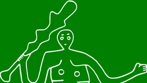
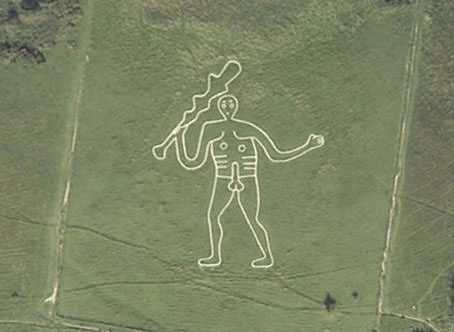
By now, we’ve strayed from accidental prick territory firmly into purpose-drawn penis land. The impulse to draw a penis on the landscape is understandable, and ancient: few things are so easily drawn, and so widely understood. For a very old (though probably not prehistoric) example, see the Cerne Abbas Giant, a.k.a. the Rude Man.

One man and his club (Image: Atelier Coulthart)
The 180-foot (55-metre) Giant is one of dozens of hill carvings across Britain, and like many of them is of doubtful antiquity. Some claim he represents the Celtic god Nodens, or the Greek hero Hercules, which would make him thousands of years old. Yet the oldest reference to the Giant dates back no further than 1694. One theory is that monks from a nearby abby cut the figure into the hillside as a joke against their abbot. The figure’s prominent (30-foot, 7-metre) penis gave rise to a few fertility rites: women trying for a baby were said to conceive soon after sleeping on the Giant’s body (no prizes for guessing where exactly), while women wishing to keep their lovers faithful would circumambulate the figure three times.
More recent examples include a riot ofphalli carved into the lawn of a school in New Zealand, captured by satellite and discovered via Google Maps, and including the two monumental examples shown here. The overhead images of Fairfield College in Hamilton, on New Zealand’s North Island, were taken in 2009 and the effect of the weed killer has probably worn off by now. But despite plans by the school’s principal to ask Google to blur or change the image, the antipodean answer to the Cerne Abbas Giant can still be seen on Google Maps. This Metro article mentions six penises on the school’s lawn, but we counted only five…

New Zizi-land (Image: Metro)
If run-drawing, chalking or burning penises on the landscape is too much trouble for you, why not consider buying this charming example of penile cartography, handily doubling as a shower curtain? Connaisseurs will recognise this as a map of the New York subway system, disguised as a cross-section of the male anatomy – now we know why they call it Man-hattan.

Nothing to see here (Image: Cafepress)
If you think that’s far out, get this: phallic cartography is conquering space. This image shows the Mars Rover kicking up dust in a by now very familiar pattern. Is this an coincidence? Or is the intrepid explorer just completing a ‘dick run’?

Extraterrestrial smut (Image: NASA)
Strange Maps #674
Got a strange map? Let me know at [email protected].


