New navigation system works inside and underground — where GPS fails
- GPS is a group of 31 satellites, constantly transmitting radio signals from about 12,500 miles above Earth’s surface.
- Satellite signals can reflect off solid surfaces, making the navigation system incapable of accurately pinpointing the locations of GPS receivers indoors, underground, and underwater.
- Researchers have now developed a new type of navigation system in which receivers detect muons, subatomic particles created by collisions between cosmic rays and particles in Earth’s atmosphere.
A new navigation system that tracks subatomic particles constantly bombarding Earth could help us get around indoors, underground, and underwater — all the places GPS fails.
The challenge: GPS (the Global Positioning System) is a group of 31 satellites, constantly transmitting radio signals from about 12,500 miles above Earth’s surface. Receivers in phones, cars, planes, and ships then use data from multiple satellites’ signals to calculate their own locations on Earth.
“Using muons, we have developed a new kind of GPS… which works underground, indoors, and underwater.”
HIROYUKI TANAKA
While GPS has revolutionized surface transportation, satellite signals can reflect off solid surfaces, making the navigation system incapable of accurately pinpointing the locations of receivers indoors, underground, and underwater.
GPS signals can also be jammed or spoofed — militaries and cybercriminals can take advantage of this to break the GPS system or cause receivers to display inaccurate information.
Cosmic navigation: Researchers at the University of Tokyo have now developed a new type of navigation system in which receivers detect muons — subatomic particles created by collisions between cosmic rays and particles in Earth’s atmosphere — rather than satellite signals.
“Cosmic-ray muons fall equally across the Earth and always travel at the same speed regardless of what matter they traverse, penetrating even kilometers of rock,” said researcher Hiroyuki Tanaka.
“Now, by using muons, we have developed a new kind of GPS, which we have called the muometric positioning system (muPS), which works underground, indoors, and underwater,” he continued.
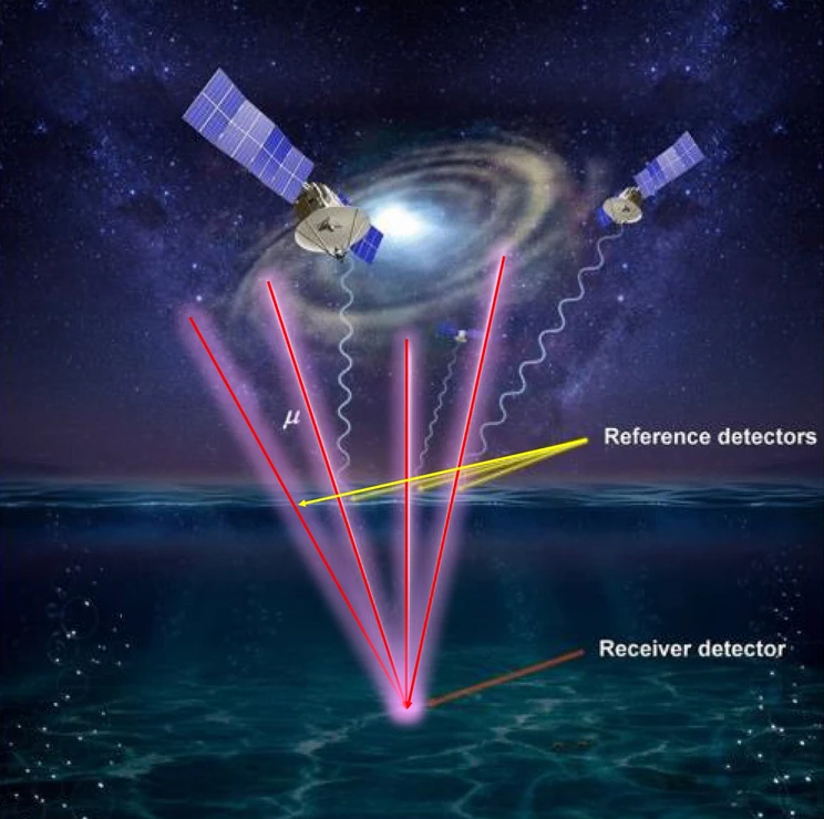
The receiver can be located by looking at the distance between it and multiple reference detectors.
How it works: The muPS system requires a receiver and multiple “reference detectors” positioned above it. The time it takes muons to travel through a reference detector and on to the receiver can be used to determine the distance between them.
The location of the receiver can then be triangulated by looking at the distance between it and multiple reference detectors.
The UTokyo team’s first iteration of their navigation system, unveiled in 2020, was designed to monitor changes in the seabed, and through computer simulations, they demonstrated that it was possible to determine the coordinates of an underwater receiver.
The receiver had to be connected to an above-water station via a wire, though, which restricted its movement.
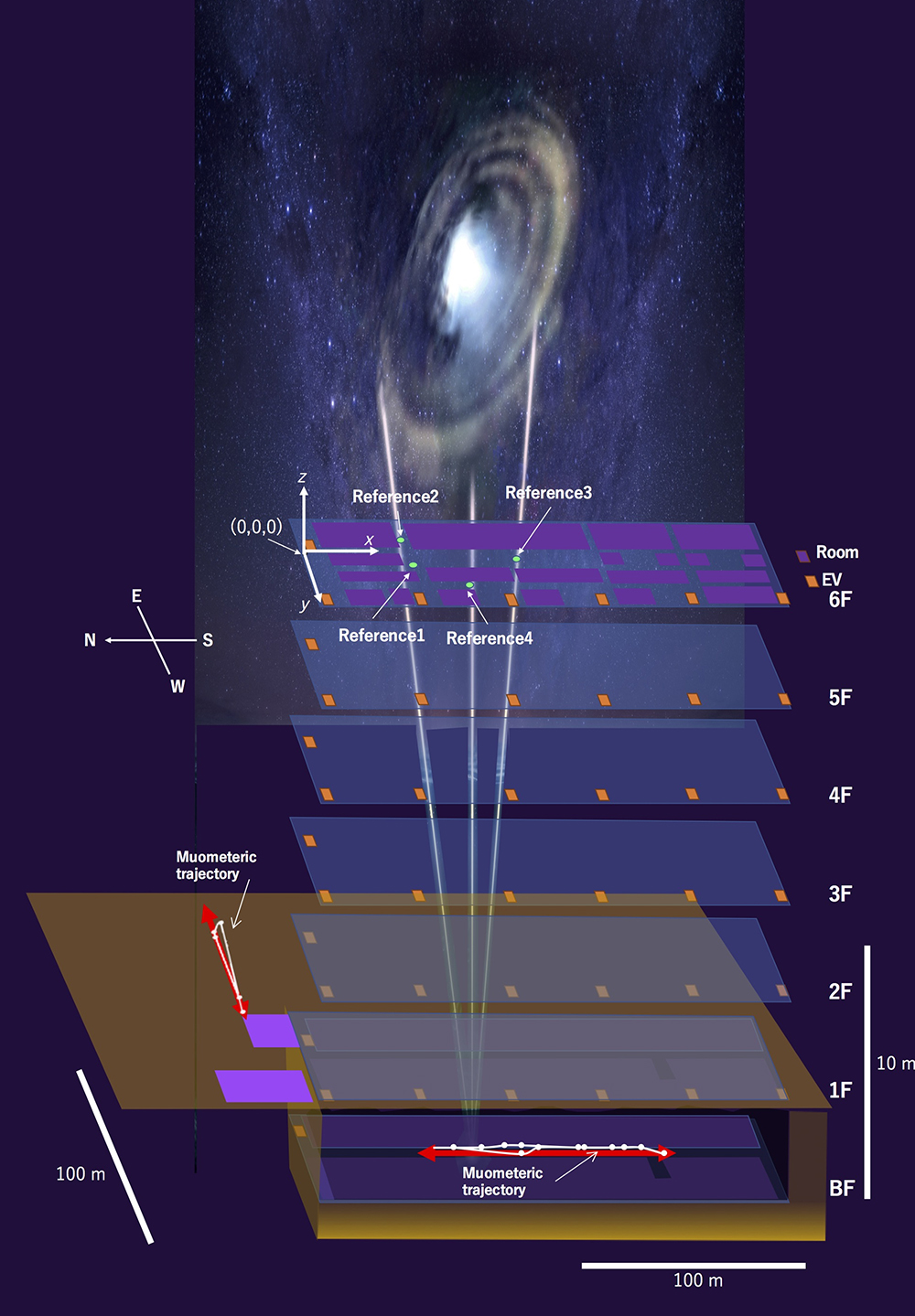
In their latest study, published in iScience, the team demonstrated a wireless version of the tech, which they call the “muometric wireless navigation system” (MuWNS).

This time, they placed their reference detectors on the sixth floor of a building. A person holding a receiver then walked along the corridors of the basement, and using measurements from the reference detectors and the receiver, the scientists were able to recreate their path.
The cold water: The new navigation system didn’t work in real-time, and there’s still plenty of room for improvement in terms of accuracy.
“The current accuracy of MuWNS is between 2 meters and 25 meters, with a range of up to 100 meters, depending on the depth and speed of the person walking,” said Tanaka. “[This] is still far from a practical level. People need one-meter accuracy.”
Looking ahead: Tanaka believes incorporating chip-scale atomic clocks (CSAC) into MuWNS will enable real-time measurements at one-meter accuracy, but the tech is currently out of even his team’s reach.
“CSACs are already commercially available and are two orders of magnitude better than the quartz clocks we currently use,” he explained. “[T]hey are too expensive for us to use now, but I foresee that they will become much cheaper as the global demand for CSAC for cellphones increases.”
If CSACs do become common in phones and other consumer tech, the other components needed for MuWNS can already be made small enough to fit into the devices. That means it might one day be common to carry a muon-detecting receiver wherever we go.
This could be hugely useful following disasters in which people are trapped underground or in rubble. As Tanaka told Freethink, flying drones equipped with reference detectors over the area could allow first responders to identify the locations of buried cell phones — and the people carrying them — with centimeter-level accuracy.
This article was originally published by our sister site, Freethink.
![]()