


A geography column on history and society.
The small English village of Langton Matravers, on the Dorset coast, until recently had just one small claim to fame. In 1914, a young Ian Fleming, later the author of the James Bond novels, attended Durnford Preparatory School here. By all accounts, he hated it. Perhaps he would have been more at home at one of the two other prep schools in town, predictably named Spyway.
All three schools have long since closed, but no matter. On November 2, 2022, Langton Matravers wriggled itself into another footnote in the history books. For it was here that the “triple alignment” made landfall in Great Britain.
Three kinds of north
While that sounds like a sinister coalition of evildoers straight out of one of Ian Fleming’s creations, the phenomenon was not of sorts to frighten the locals — merely to delight cartographers. In other words, the village made mapping history. The term refers to the alignment of true north, magnetic north, and grid north, a first in mapping history, and an event that may not recur for several centuries, if ever.
True north is the easiest of the three to explain. This is the direction of the actual North Pole, the place where all lines of longitude converge. It’s also called “geographic north.”
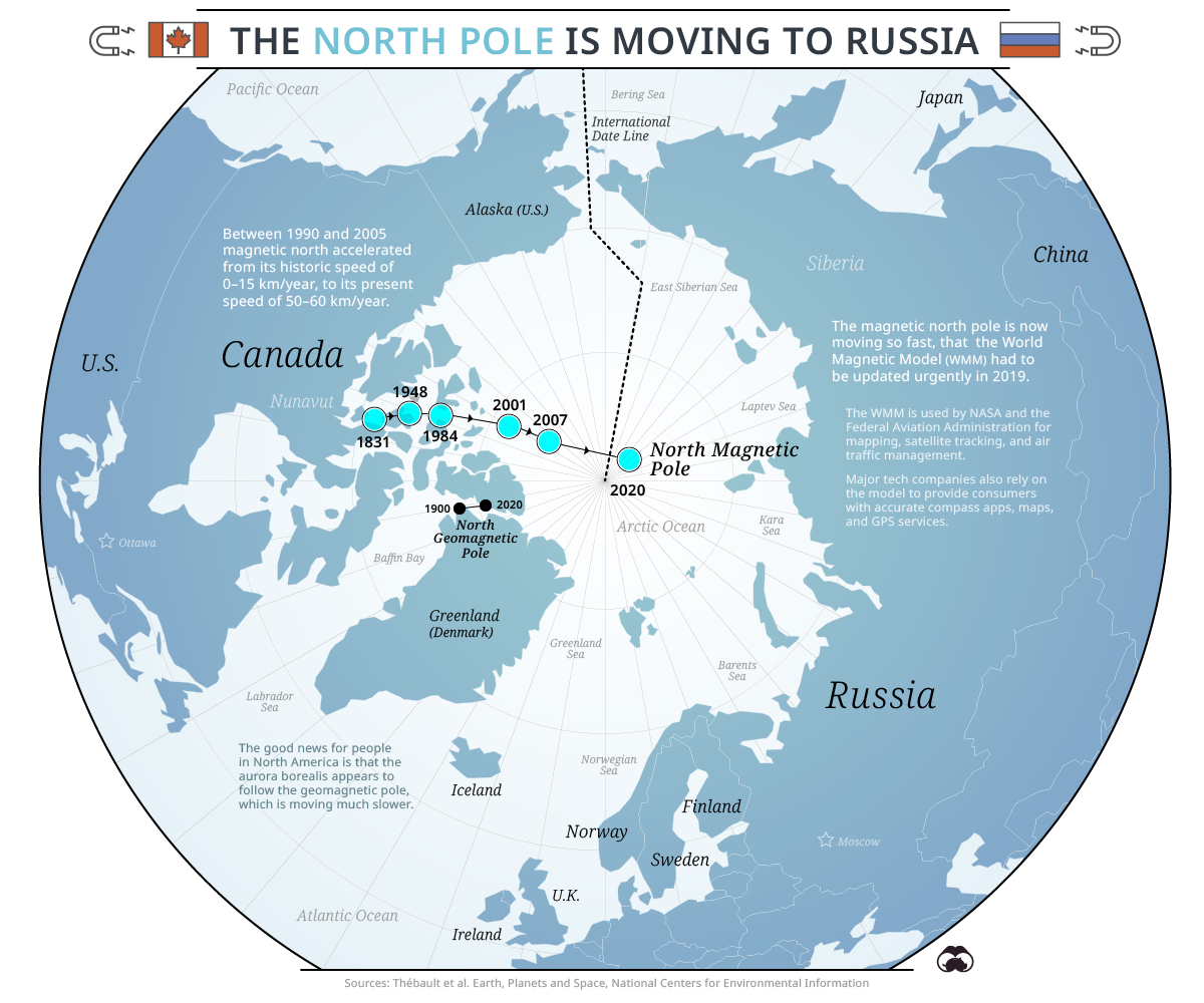
Magnetic north is the direction your compass points to. Not only is this different from true north, it also moves. The position of magnetic north shifts in response to changes in the Earth’s liquid outer core. (And it’s been shifting much faster in recent years than in the preceding century and a half.)
Grid north is the direction north on a flat map. Since the Earth is a globe, grid north will be slightly different from true north, except for a baseline. For maps produced by Ordnance Survey (OS), Britain’s national mapping agency, this baseline, also known as the graticule line, is two degrees west of the Prime Meridian at Greenwich (and is marked in blue in the map at the top of this page).
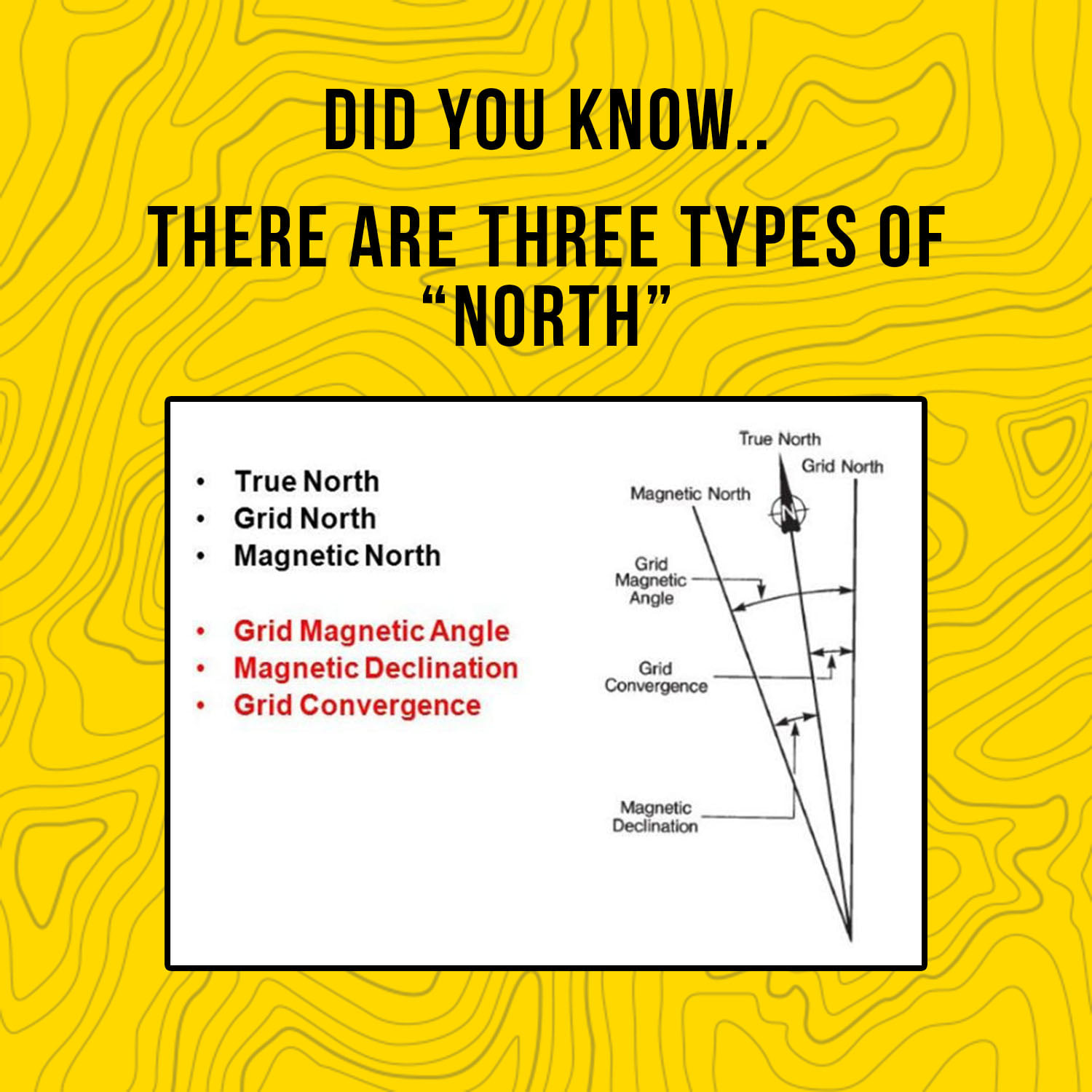
When you’re using a compass to navigate, it’s important to know the difference between grid north and magnetic north, a difference also known as the “grid magnetic angle.” That’s why many topographic maps, including those produced by the OS (but also USGS maps) indicate the difference between these three different norths.
A mecca for map nerds
Since 2014, and for the first time since the 1660s, the orientation of magnetic north in Britain has been moving east, in the direction of the OS baseline. Grid north (the “graticule line”) passes right through Langton Matravers. Along this line, true north and grid north are already in alignment. And now, due to the movement of the north magnetic pole, magnetic north is in alignment as well.

To be clear: the alignment is not a line, it’s a point – the point where one line (the direction of magnetic north) intersects with the other two (which are identical).
If you go to Langton Matravers now — as many map nerds have, according to reports in the British press — your compass will point toward magnetic north, true north, and grid north all at the same time. But the village’s second brush with fame will be brief. Because the north magnetic pole keeps moving, so will the point where it intersects with 2° W.
Slowly but inevitably, that point will be traveling north across Britain. By Christmas, it will already be in Poole, about 10 miles (16 km) further north. Meaning that at that time, and for a short while, compasses in Poole will be pointing not just to magnetic north, but also to true north and grid north. The triple alignment will continue up across England, crossing Britain’s second city Birmingham, until it dips back into the sea, at Berwick-upon-Tweed in the north of England, around August 2025. It will re-emerge at Drums, north of Aberdeen, around May 2026 and, after a short stint in Scotland, leave the UK from Fraserburgh, also in Aberdeenshire, around July 2026.
This is the first time in history that true, magnetic, and grid north are in “triple alignment” in the UK. Let’s qualify that: the first time in cartographic history. The Ordnance Survey came up with the National Grid system for its maps only in 1935.
The longer the timescale, the more unpredictable the movements of the north magnetic pole. Perhaps the “triple alignment” will one day return to Britain’s shores. But it could easily be several centuries before that ever happens.
Strange Maps #1178
Many thanks to Julian Hemsted for sending in this story. For more on this, see this article in the newsroom of the Ordnance Survey, and check out this short video.
Got a strange map? Let me know at [email protected].

The Power of Play


