The Indian Ocean has the world’s largest gravity hole. Now we know why
- The Indian Ocean is home to the world’s largest gravity anomaly.
- It was first discovered in 1948, but explained only in May of this year.
- Indian scientists say it was caused by fragments of the ancient Tethys Ocean floor.
Dear Indian Ocean, please don’t take offense, but: Why is your gravity hole so big? That question had been baffling scientists ever since the hole was discovered back in 1948. Now a team from the Indian Institute of Science (IISc) thinks they have found the answer: The “hole” in the Indian Ocean is caused by fragments from the sunken floor of another, much older ocean.
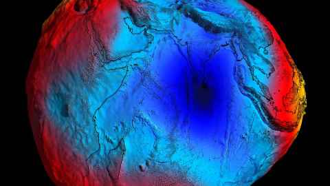
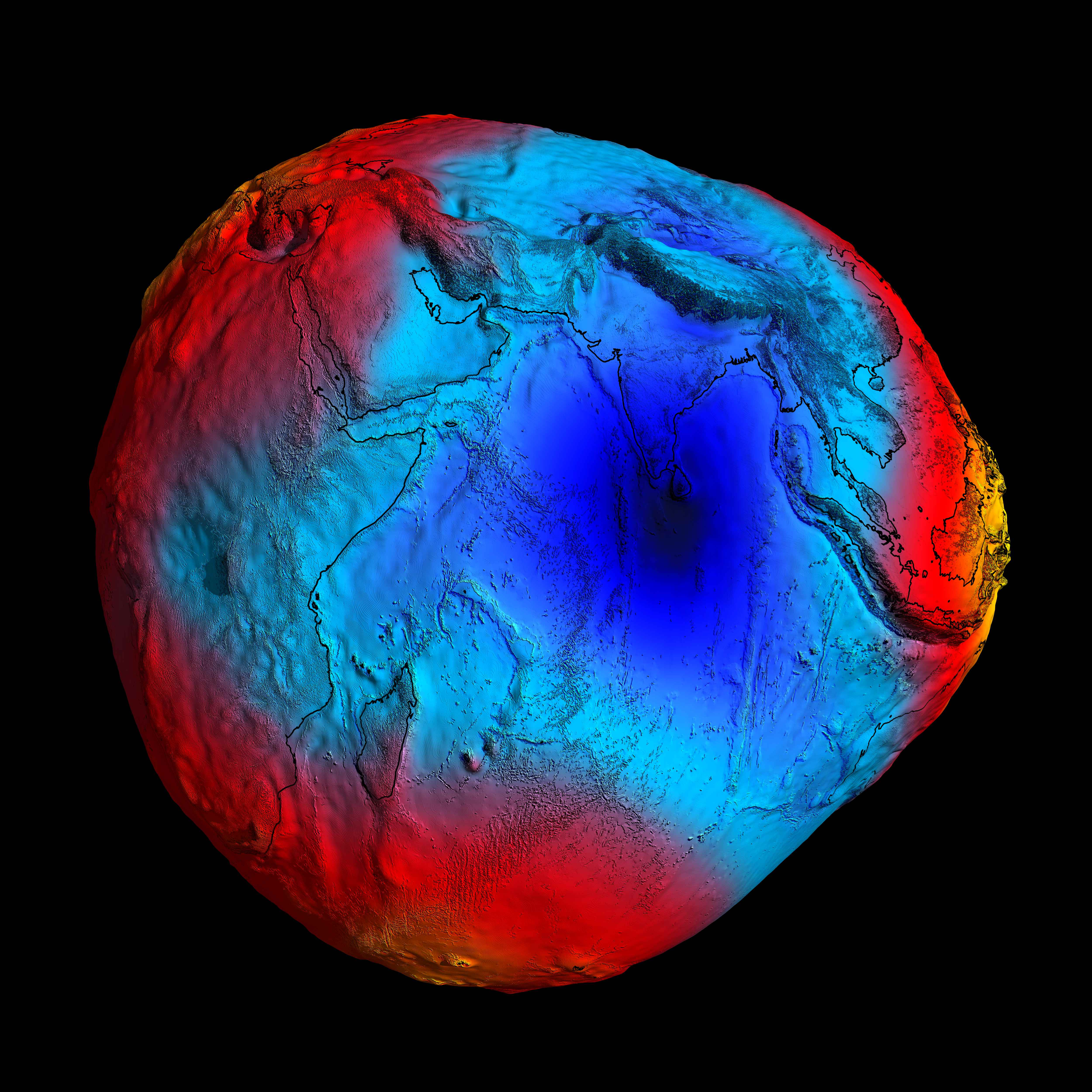
In a mysterious part of the Indian Ocean, the pull of gravity is much weaker than anywhere else on Earth. This gravity hole, the world’s largest (and deepest) gravitational anomaly, is officially known as the Indian Ocean Geoid Low (IOGL). (A geoid is a theoretical model of sea levels worldwide, with its irregularities corresponding to variations in the Earth’s gravity.)
There’s nothing mysterious per se about gravitational variation, which corresponds to differences in the density of the subsurface (and submarine) layers of rock. What was unexplained, was the size and amplitude of the anomaly in the Indian Ocean.
More air than water
The gravity hole is centered about 1,200 km (750 mi) southwest of Kanyakumari (a.k.a. Cape Comorin), the southernmost tip of the Indian subcontinent. The circular depression in the ocean has an area of about 3 million sq km (1.2 million sq mi), which is almost the size of India itself. Due to lower local gravity, the sea level in the IOGL is up to 106 m (348 ft) lower than the global average. That adds up to a huge volume of air where there should be water. A back of the envelope calculation suggests that, due to the anomaly, about 100 cubic km (25 cubic miles) of water is being displaced.
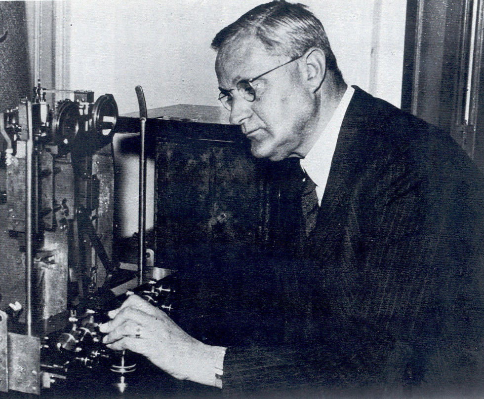
The anomaly was discovered by Felix Andries Vening Meinesz, a Dutch geophysicist who had invented a device to measure gravity at sea. (It was nicknamed the “Golden Calf,” because of its color and because sailors on submarines carrying the instrument had to remain motionless in their bunk during measurements, a nuisance for which they received extra pay.)
As a pioneer of submarine gravimetry, Vening Meinesz spent much of his career roaming the oceans in submarines and research vessels. He discovered several anomalies in Earth’s gravitational field, which he attributed to plate tectonics, none larger or stronger than the one in the Indian Ocean.

The eminent Dutchman — one of his research fellows was the geologist B.G. Escher, the brother of the graphic artist M.C. Escher — was thinking in the right direction, but his era lacked the computing power to pinpoint a more proximate cause. The actual cause of the IOGL remained unknown until last May, when the journal Geophysical Research Letters published a study by IISc researchers.
Starting the clock 140 million years ago, the IISc team ran various simulations through a supercomputer to explore how tectonic and volcanic forces shaped the world as we know it. The models that produced a gravity hole closely resembling the actual IOGL all had one thing in common: low-density magma plumes rising up to displace higher-density material, weakening the area’s gravity.
How it all went down
Here’s the likely scenario: Around 120 million years ago, the Indian plate broke off from the supercontinent of Gondwana, and went on a collision course with the Eurasian plate. That collision would eventually give rise to the Himalaya mountains. But before it got there, the Indian plate passed over the Tethys plate, closing up the ancient ocean of that name.
As fragments of that plate — so-called “Tethyan slabs” — were shoved deeper into Earth’s mantle, they displaced some of the material trapped in what is known as the “African blob,” a continent-sized bubble of magma about 1000 km (600 miles) under East Africa. Some 20 million years ago, that relatively light substance rose toward the surface in plumes.
Together with the mantle structure near the geoid low, those plumes are responsible for the gravitational anomaly off India’s southern tip, the IISc team writes. While the researchers were able to stick an estimate on the age of the geoid low, it’s hard to predict when or if it will ever shift or disappear.
Strange Maps #1222
Got a strange map? Let me know at [email protected].