The Ghost Subway of Rochester, New York
“I was researching the town that I’m going to college in next year,” Duane Thomas Fields writes (about Rochester, New York), “and I came across the fact that the city had a subway for a time in the early 20th century. It hasn’t run since 1956 and the tunnels sit abandoned today. But in researching whether there was support for modern revival, I came about a map of what the subway map could look like today, with the original line plus proposed extensions.”
For much of late 19th and early 20th century, Rochester was among America’s two dozen biggest cities. But not anymore, not by a long shot: the former economic powerhouse by Lake Ontario’s southern shores has slipped to 97th place, and into relative obscurity. At its peak, Rochester had a third of a million inhabitants; now, at just over 200,000, it at least has the consolation to be still the biggest Rochester in the world. It out-sizes all 18 other Rochesters, including the original one (in England, with under 30,000 inhabitants). More importantly, metropolitan Rochester (about 1 million inhabitants) still is the second major economic hub in New York State, after – obviously – New York City.
One of those second-tier metropolises that made the American hinterland hum with industry, Rochester’s history can be gleaned from the epitheta it has strung together in its 200 years of existence.
Strangely enough, Rochester owed its subway to the banishment from town of an earlier mode of transport. In 1900, the city fathers found the Erie Canal‘s route straight through the city centre to be an unnecessary eyesore, and decided to divert it away from the urban agglomeration. The disused canal bed thus became the prime location for Rochester’s subway route. The last ship sailed through town in 1919, the first train travelled on the Rochester Industrial & Rapid Transit Route (RI&RTR) in 1927 (the overhead serving as Broad Street). For the next three decades, Rochester would be served by a subway, apparently the smallest city in the world ever to possess one.
Subway is a bit of a misleading term for the Rochester transit system, as only two miles of it were actually in the (ex-canal) tunnel; but it could be taken to refer to the fact that it was a separate, rapid-transit system. And in fact, most of it ran in an open cut below the surface, crossed by bridges. The last passenger service was in 1956, although freight transports continued for some time after this. The tunnels continue to form part of Rochester’s historical legacy, if only for the controversy they generate: should they be used for a new public transport system (be it a pedestrian tunnel, or even a re-instated passage of the Erie Canal) or should they be filled up, finally relieving the city of maintenance costs? The discussion recently seems to have tilted the latter way.
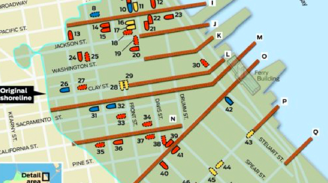
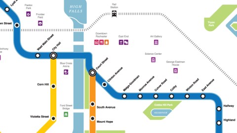
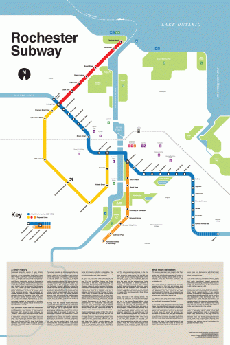
On this map, the blue line represents the Rochester Subway as it existed in the former Erie Canal bed, with the actual stations (from General Motors in the northwest to Rowlands in the southeast). The geometrically inclined map possibly distorts actual distance, as the station named Halfway seems much closer to the southeastern terminus than to the other one. The yellow, red and orange lines were all at some time proposed as extensions to the Subway, and would have greatly enlarged the scope of the original transit system.
This beautiful map, then, is an exercise in nostalgic futurism: it imagines what the world would have looked like if the center had held, if crises had not intervened and growth could have continued. But Rochester will never look like this. With the tunnels slated to be put beyond use, this extended Rochester Subway will be condemned to a ghostlike existence, only on maps and in the imagination – no more than an engineer’s pipe dream.
Many thanks for Duane Thomas Fields for pointing me in the direction of rochestersubway.com, a site devoted to the part-defunct and part-fictional transit system. Special thanks to that site’s webmaster, Mike Governale, for providing me with this map.
Strange Maps #376
Got a strange map? Let me know at strangemaps@gmail.com.