Global warming makes hurricanes stronger, but less frequent
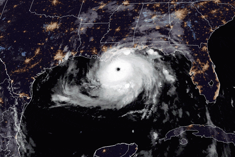
- As Hurricane Francine strikes New Orleans, a new tropical depression is currently forming in the Atlantic: likely to soon become Tropical Storm George.
- Even though this year, 2024, has a slightly greater number of Atlantic storms than most years, the overall frequency of hurricanes is not increasing due to climate change; that’s a myth.
- In fact, hurricanes are becoming less frequent as the Earth’s temperature rises, although the storms themselves are, on average, stronger than they used to be. Here’s the science behind why.
Here in our Universe, there’s a formula for understanding how any physical phenomenon works. If we can come to know the fundamental rules governing any physical system, and if those rules remain constant over time, then we can input the parameters that we have at any moment and evolve that system forward in time, allowing us to predict its future behavior. These laws enable certain phenomena to arise as long as specific physical conditions are met:
- gravitation and orbital parameters determine the tides,
- solar ejecta and the magnetic connection between the Earth and Sun determine the aurorae,
- and the interface between Earth’s windy atmosphere and the warm ocean waters determine the formation and properties of hurricanes.
The specifics of whatever conditions are in place at any moment in time help determine things — like frequency and intensity — of any such physical phenomenon.
For chaotic systems like hurricanes, there’s inevitably going to be a certain amount of variation and variability from event-to-event, year-to-year, and decade-to-decade in terms of what happens on Earth. But if there are long-term, sustained changes to our planet’s conditions, that’s going to affect the overall behavior of phenomena such as hurricanes here on Earth. As Hurricane Francine bears down on Louisiana, across much of the same region that was catastrophically hit by Hurricane Katrina back in 2005, it’s time to examine just how hurricanes work, and why we can no longer ignore the effects of global warming as part of the conversation surrounding them.
Here on Earth, we understand the physical system of our atmosphere pretty thoroughly. We know:
- how much energy is incident on the atmosphere from the Sun,
- how much — both on average and under a given set of conditions — heat reaches the surface and how much gets reflected back into space,
- how much heat is trapped and re-radiated by various points along the surface and by cloud cover and the atmosphere in general,
- how our planet orbits the Sun and rotates on its axis,
- how the atmosphere circulates as a function of latitude,
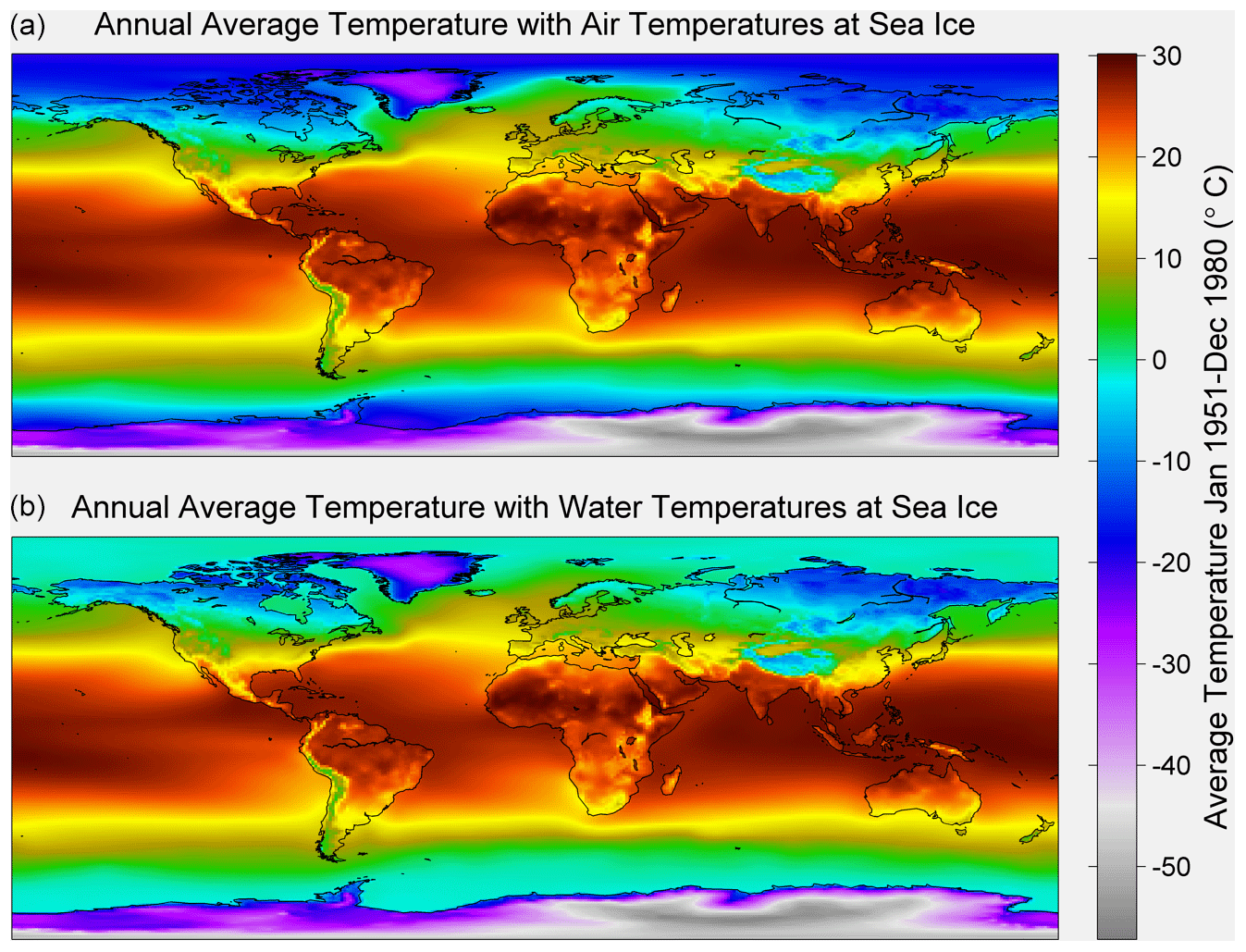
- and what the ocean surface temperatures are at any moment in time.
Through surface-level, atmospheric, and space-based instruments, we have an incredibly precise network that provides global coverage of these and many other physical properties of Earth.
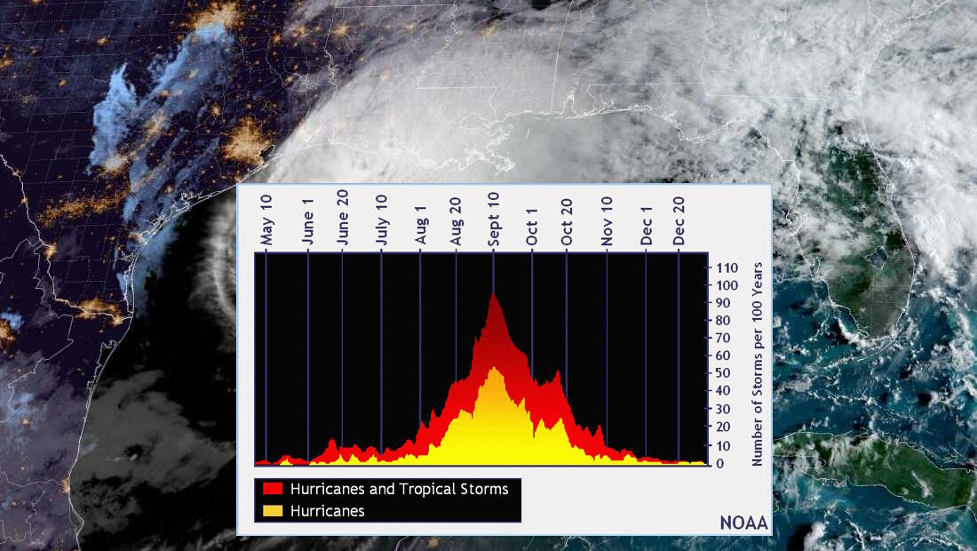
Although every June through November marks Atlantic Hurricane season, the peak of that season normally occurs from August through October: where the number and intensity of hurricanes are the most frequent. Dependent on where in the world they form, they might be called hurricanes, typhoons, or cyclones, but they’re all the same phenomenon, falling under the umbrella of tropical cyclones. From a physical point of view, they’re all but identical.

If you want to make a tropical cyclone on Earth, there are a few ingredients that are absolutely mandatory. Some of them are easy to come by, others are a little bit rarer. Specifically, you need:
- warm water and, specifically, warm waters that have significant oceanic depths, where the temperatures are at least 80°F / 27°C down to a depth of at least ~50 meters / 150 feet,
- an atmosphere with a significant temperature gradient, where higher altitudes are significantly cooler than surface/sea level temperatures,
- wind, which moves the air over the ocean in primarily a longitudinal (east-west) direction, but which also exhibits some shearing: required to cause rotation,
- and air that has a significant amount of moisture at high (~5 kilometer / 3 mile) altitudes.
This typically leads to summer/autumn hurricanes in both hemispheres, in tropical regions (where waters are warmest), displaced a fair distance away from the equator (where the Coriolis force can lead to rotation), along continental coasts and island chains (close to deep-enough waters), and only under favorable conditions. A disruption in any of these conditions can cause a tropical depression to peter out, rather than to develop into a sustained, potentially hazardous storm.
The story begins close to the surface of the Earth: where the majority of the incident sunlight on our planet finally gets absorbed. The surface of the Earth — whether at sea level or on dry land — is generally hotter than either the air directly above it or the solid/liquid material directly below it. When you heat the ocean, it takes a long time for the heat to propagate to the lower layers, because warm water is less dense and “floats” atop the colder waters beneath it. In the ocean, the warm surface waters stay confined there for long periods of time due to a simple physical principle we’ve all heard at one time or another: heat rises.
But heat also rises in the atmosphere, where the hot surface air rises up, or more accurately, the denser, colder air sinks down to displace the hot air near the surface. As the cold air sinks and the warm air rises, the rising warm air carries water vapor with it up into the atmosphere. As the warm air cools, the water vapor within it condenses into liquid droplets: a phase change from gas to liquid. Just as the act of boiling water (converting it from liquid to gas) requires the input of heat, the act of condensing water (converting it from gas to liquid) causes the release of heat, which heats the surrounding air even further. This warmed air then rises further, allowing the warm, moist air flowing over the ocean beneath it to continue to rise.
In very short order, you can build up thick clouds and wide areas which alternate between rising (warm) and falling (cool) air.
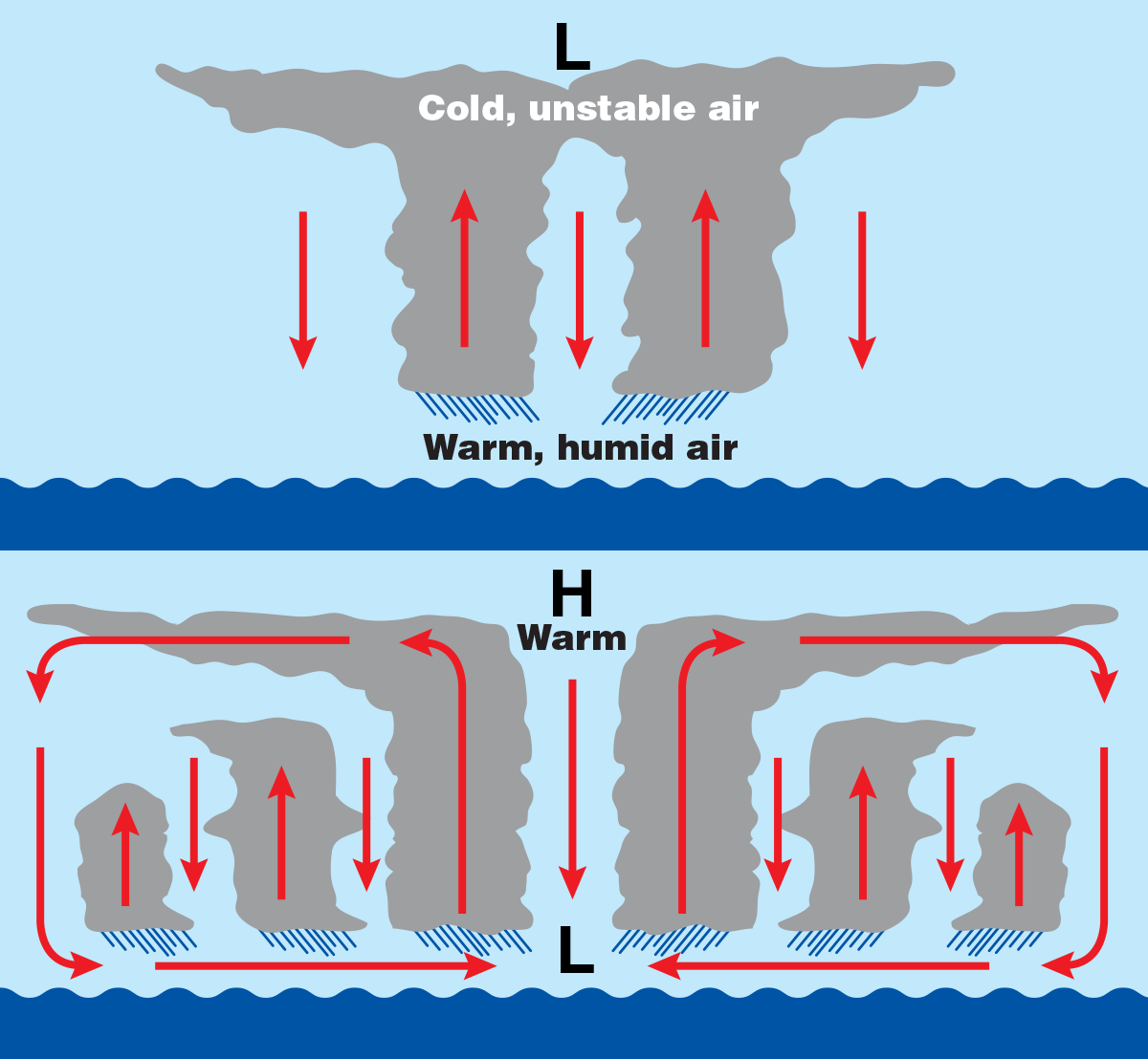
Over the oceanic regions from approximately 10° to 30° latitude, both north and south of the equator, these conditions are all occasionally met, simultaneously. As the winds pass over the water’s surface, water evaporates, with the water evaporating faster for every degree over that critical 80 °F/27 °C threshold. The warm air becomes moist, rich with water vapor, and then begins to rise. As that warm air rises, both the air and the water vapor cool, condensing the vapor into clouds and causing the remaining air to heat up (and rise) further. As a result, you get thick, cumulonimbus clouds that form: rain clouds.
In conditions that won’t form a tropical cyclone, this is the end of the line. But when the conditions are favorable for it, that rising warm air causes the cloud-tops to heat, which subsequently raises the air pressure. Air tends to move from high pressure to low pressure, and that can cause lateral motion away from the center: outward. When the air is no longer above a warm, rising region, it can fall again, creating a larger, wider, “stacking” area of clouds. If there’s circulation also present, this can lead to spinning. This spinning helps the winds increase in speed, which can lead to this rising-and-falling air, rich with moisture, spinning faster and faster.
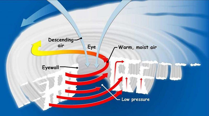
This cloud-rich air can then develop into a tropical depression, a tropical wind storm, and eventually, with enough power, a full-fledged tropical cyclone. The ones that strike the Atlantic and gulf coasts of the Americas are known as hurricanes.
Hurricanes are not only exceedingly powerful natural disasters, but are also regularly destructive. Hurricane Francine, much like 2005’s Katrina, 2012’s Isaac, and 2021’s Hurricane Ida, is likely shaping up to be a multi-billion dollar disaster, accompanied by flooding, severe storm surges, and even potentially a temporary reversal in the flow of the Mississippi River.
There’s no doubt that natural variability plays a huge role in the frequency and intensity of hurricanes that occur in any given year. Weather patterns, the jet stream, ocean currents, cloud cover, the presence or absence of aerosols, and many other properties (including whether it’s an El Niño or La Niña year) can affect how many storms occur and how severe they are — both in terms of strength upon landfall and strength over the ocean — every single time. However, there are changes we’ve wrought upon the planet, including changes to the global average temperature, the amount of heat in the oceans, the average height of sea level, and changes to air and water currents, among others, that have the potential to affect the tropical cyclones that form on Earth.
According to the latest report from the Intergovernmental Panel on Climate Change (IPCC), there are a number of ways that the human-caused changes to the climate have affected hurricanes, as well as a number of ways that we expect these changes to influence hurricanes as we move forward through the remainder of the century. However, not every claim is actually supported by the data, so it’s worth going through and pulling out what the science clearly says, and why.
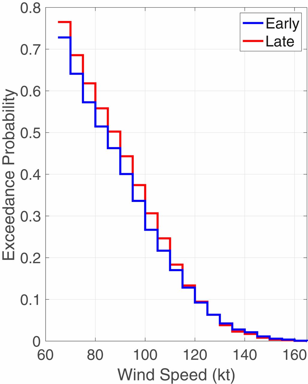
Already, we know that humans have warmed the Earth by somewhere between 0.8 C (1.4 °F) and 1.3 °C (2.3 °F) since the late 1800s. The fact that sea levels have already risen tells us that coastal flooding should have worsened with time, and in fact, it has. In the northwest basin of the Pacific Ocean, tropical cyclones have been reaching peak intensity at progressively higher latitudes in recent years: a change that cannot be explained with natural variability alone. Similarly, the fraction of tropical cyclones that achieve at least Category 3 intensity (~50 m/s wind speeds or higher) has increased over the past four decades, which again is not consistent with the expectations from natural variability alone.
These three effects — coastal flooding, the away-from-the-equator migration of peak intensity storms in the Pacific, and the fraction of more-intense tropical cyclones — can all, with medium confidence or greater, be attributed directly to global warming.
However, globally, hurricanes have not become more frequent; that’s actually a piece of climate misinformation, alongside many others, that are being repeated by numerous sources. We didn’t really begin monitoring the entire globe — including the oceans — for hurricanes and other tropical storms until the 1970s, meaning that our earlier records are woefully incomplete. It has been noted that the number of storms in the Atlantic hurricane basin has increased since the 1970s, but that is not attributable to global warming. Rather, two different studies show that aerosols from human activity and volcanic forcings drove that recent spike.
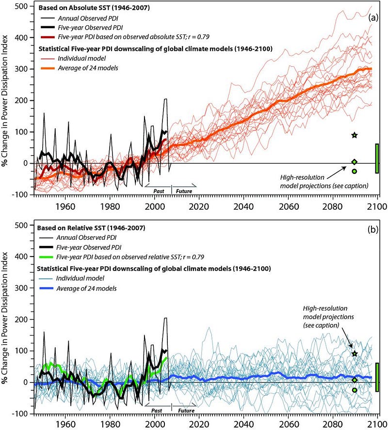
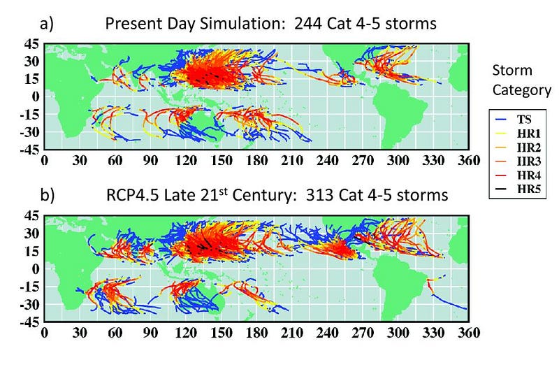
In fact, the frequency of tropical storms in the Atlantic are expected to decrease over the coming decades, as model simulations predict less frequent but more intense storms across the world for the remainder of the 21st century. We fully anticipate that tropical cyclones will increase in both average and maximum intensity, and bring, on average, more rain with them when they do make landfall. Coastal inundation levels will continue to increase as well.
However, there is no strong, compelling evidence to indicate that tropical cyclones are becoming more frequent, that they’re intensifying more rapidly than they used to, or that hurricanes are more likely to make landfall than they used to. Claims to the contrary are unsupported by the current scientific evidence.
The biggest change that global warming brings along with it, as far as hurricanes and tropical cyclones go, is the one you’d expect most: the fact that things are now warmer than they used to be. A warmer Earth means warmer oceans, which means greater regions of our planet with ocean temperatures at or above the 80 °F/27 °C threshold, including at higher latitudes. Warmer water takes up more volume, so sea levels are higher and coastal flooding is more common and intense. The continued warming means that the warmest ocean locations will exceed that 80 °F/27 °C threshold by even greater amounts than previously. And that increased temperature drives the amount of heat and water vapor carried up into these tropical cyclone-creating events.
That translates into:
- more rainfall associated with these storms,
- more intense storms and wind speeds,
- and more consequential coastal floods and damage as a result,
three of the most confident predictions concerning global warming and hurricanes to come out of the latest IPCC report. As the sea surface temperatures — what climatologists call SSTs — continue to increase, they will drive the increase in wind, rain, and flooding severity of tropical cyclones expected to continue throughout the century, where the frequency of category 4 and 5 hurricanes may increase by ~30% over their presently observed occurrence rates.
Whenever you have a natural phenomenon that impacts the health and safety of Earth’s human population, it’s vital that we analyze it in a scientific and scrupulous fashion. The fact that we only have quality global data concerning tropical cyclones going back to the 1970s or 1980s — and yet, can still draw even modestly confident conclusions — should help impress upon all of us how significant these effects are. In terms of rainfall, wind speed, and the impact on coastal areas, global warming has likely already impacted the tropical storms we’ve been seeing in recent years, and is poised to severely worsen their effects moving forward. Higher temperatures mean warmer ocean air, and that drives the overall intensity of hurricanes, cyclones, and typhoons.
However, it’s incorrect to claim that tropical cyclones are getting more frequent. Not only is that unsupported by the evidence, but model simulations continue to predict that as global temperatures continue to rise, the number of total tropical cyclones will actually decrease. However, the intensity of both typical and extreme storms is expected to increase, with the damage from both typical and extreme storms expected to increase in severity. It’s a mixed bag: each individual storm should be more destructive, but there shouldn’t be as many total storms, overall. There’s a lot left to learn and much that must still be studied, but preventing the Earth from warming further is still the most critical piece of climate action that needs to be taken. We can get there without exaggerating or misconstruing the truth; reality is harsh enough as it is.