Mapping a White Christmas
Jesus Christ and Bing Crosby have more in common than a rapidly aging fan base. They share the responsibility for an annually recurring socio-meteorological phenomenon — White Christmas Anticipation (WCA).
Jesus is to blame for having his fake (1) birthday in mid-winter, Crosby for famously singing about his fond recollections of the snowy Christmases of yesteryear (2). With over 100 million copies sold worldwide, “White Christmas” is the best-selling single of all time.
Of course, WCA only occurs in regions where there is a degree of uncertainty that a White Christmas will actually happen. So no WCA in Phoenix, Arizona (probability 0 percent), nor in Fairbanks, Alaska (probability 100 percent).
Any place in between, and you can bet the talk on the news and in the shops in the run-up to December 25th will at some point turn to the likelihood of snowfall (3). As past occurrences have been archived, that likelihood can be mapped, as it is here.

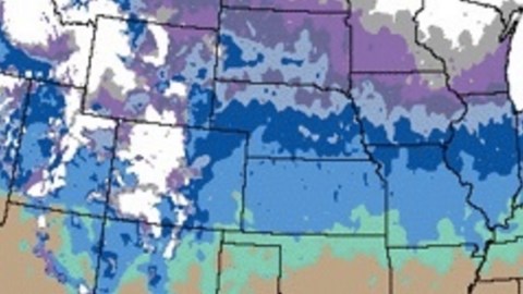
As the brown band on this map of the 48 contiguous states shows, six whole states have virtually no (
Three more fare only marginally better, fringed as they are with the green-bluish band indicating 5 to 10 percent chance: Texas, Oklahoma, Arkansas, Tennessee, and North Carolina.
Chances of snowfall increase farther north, or higher up: California is mainly brown, but white (>90 percent chance) in the narrow band that coincides with the Sierra Nevada mountain range. Other white zones nearby correspond to the higher altitudes of the Cascade and Rocky Mountain ranges.
White areas further inland, like the one covering the northern parts of Minnesota, Wisconsin, and Michigan, are not necessarily higher up, just higher north. If you catch my drift.
In all, the area where there’s a better-than-50 percent chance of a White Christmas (worse than 50 percent if you’re the Grinch) is fairly limited: from most of New England over Michigan and Wisconsin into the Dakotas, tapering off into Montana.
Based on data from 1988 to 2005, a White Christmas is likelier in Duluth, Minnesota (97 percent), than in Anchorage, Alaska (90 percent); as likely in Fargo, North Dakota, as in Portland, Maine (83 percent), and slightly less likely in Denver, Colorado (50 percent), than in Salt Lake City, Utah (53 percent).
There is, apparently, a statistical chance of 1 percent of a White Christmas in Miami and Los Angeles, a 2 percent chance in San Francisco and a 5 percent chance in Washington, DC.
Freak weather does produce some memorable Christmases. In 2004, the so-called Christmas Eve Snowstorm produced the first White Christmas in living memory in New Orleans, Houston, and even Brownsville, on the Texas-Mexico border. Inversely, due to an unusually warm winter, Québec City experienced its first “green” Christmas in 2006.
In general, following the pattern of ever-higher average temperatures the world over, White Christmases do seem to become rarer of late. That anecdotal notion is backed up by at least one scientific study, which confirms the declining frequency of White Christmases in the U.S. over the second half of the 20th century, especially in the Northeast.
Of course, the United States is not the only part of the world with WCA. The same can be said of Canada, albeit for a much smaller part of that country; most of it is solidly snowed under by Christmas.

Here’s a White Christmas map of Europe. Rovaniemi, in Finland, is Europe’s Fairbanks, Alaska — 100 percent chance of a White Christmas. Firenze is its Phoenix: 0 percent chance. Like the Rockies, the Alps bring the likelihood of Christmas snow south: Innsbruck, 43 percent. Russia is Europe’s Minnesota — flat, but far enough north for snow to be a near certainty (Moscow: 91 percent). Outside Russia, you need to go pretty far north for a better-than-half chance of snow, way beyond Denmark (Aalborg: 33 percent) and even halfway up Sweden (Stockholm: 49 percent).

As the planet warms, and White Christmases retreat northward toward Santa’s Redoubt, these maps may become as charmingly dated as Crosby’s hit song.
The U.S. White Christmas map found here at the National Weather Service, the Canadian one here at the Weather Doctor, the European one here on Brilliant Maps.
Strange Maps #755
Got a strange map? Let me know at strangemaps@gmail.com.
_______________________
(1) Shepherds out at night with their flock in the middle of winter? It’s more likely the Nativity occurred some time in spring or summer; also a more convenient season to hold a census. The Christmas date was set near the winter solstice in an apparent attempt to align the Christian high holiday with a pagan precursor.
(2) Crosby sang it first in the 1942 musical comedy Holiday Inn — after which the hotel chain was named. Irving Berlin wrote the song in the California desert town of La Quinta (no link with the eponymous hotel business).
(3) In the U.S., a “White Christmas” is defined as there being 1 to 2.5 cm snow on the ground at 7am local time on Christmas morning. Around the world, the definition can vary, in accordance with the local definition of ‘Christmas’ (i.e. Christmas Eve on the 24th, or Christmas Day, the 25th, or, in the Orthodox churches, any time from 6 to 8 January) and the local definition of “white” (a snow cover of at least 2 cm in Canada; in the UK, the Met Office requires snowfall during the 24 hours of Christmas Day, even melting, but discounts snow fallen on previous days).

