A Map by and for Afghans – and Against Everybody Else
“Local land for local people,” reads a graffiti in Derek Jarman’s music video for The Smiths’ 1986 single “Panic.” That’s the first thing I thought of when I saw this map. Produced a century earlier in a totally different corner of the world, is a distant echo of that same us-against-the-world sentiment. But the world won’t listen.
In the 1880s, the Great Game was entering its final phase — Britain and Russia were zooming in on the last wild bits of Central Asia that separated their respective empires. Those empires were built not only on blood, sweat, and tears, but also on ink — cartographers’ ink, to be precise. Mapping was the study-chamber precursor to bloody conquest and actual possession.
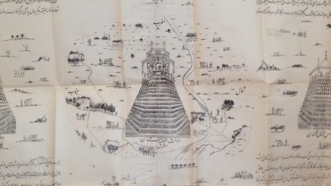
At the end of the 19th century, imperial cartographers in Moscow and Calcutta were producing enough maps of Afghanistan to make the local rulers nervous. This particular map, however, is made by the locals, for the locals. Using cartography, the very tool of foreign imperial dominance, as an assertion of their independence, this is an ingenious pushback against Empire Creep.
As the Persian inscriptions on the map indicate, it was commissioned by Abdur Rahman Khan (b. 1830), who ruled Afghanistan from 1880 to 1901 as the “Iron Emir.” Abdur Rahman’s relationship with the British was a tense balancing act. Upon his accession, the British evacuated Afghanistan — on the condition that he continue to align his foreign policy with theirs.

Abdur Rahman received an annual subsidy from the British, but refused their military assistance when Afghan and Russian troops skirmished over a disputed section of their common border. His policy was to remain both as friendly and as distant with his powerful neighbors as diplomatically possible. It is under his reign, in 1893, that the so-called Durand Line was fixed, which currently forms the border between Afghanistan and Pakistan.
The map — a rare example of native Afghan cartography — reflects that balancing act. It is anchored on five prominent fortresses and dotted with rural villages, winding roads, coursing rivers, and farmers working their fields.
A translation for the legends beneath the fortresses is not provided, but perhaps it’s not a stretch to think that the central one is the capital, Kabul. The map is “occidented”: Its top points (roughly) toward the west, i.e., towards Persia. Turkestan, part of the Russian Empire, is to the right (north); China is below (east); and India, part of the British Empire, to the left (south).
A copy of this map, photozincographed at the offices of the Survey of India in Calcutta in the late 19th century, was sold at UK map sellers Jonathan Potter, who provided a partial translation for the texts filling out the map in each of the four corners.
In the top right:
“I who am the Sovereign of Afghanistan, Emir Abdur Rahman Khan […] have had drawings prepared so the Afghan people can see their country in relation to the other four powers in the region. People’s station in life is confirmed by the Sovereign and if they act accordingly they will win his approval and love.”
Somewhere else, it says:
“I who am the Padshah of Afghanistan [Emir Khan] recognised by the British as Emir of Afghanistan in return for conducting their foreign affairs in Afghanistan”.
Other contributions to the translation of the texts are very welcome.
Although this map was intended to assert the authority of the local ruler over his people, he apparently can’t do so without referring to the British as ultimate overlords.
Many thanks to Jonathan Potter, who provided the image for the map.
Strange Maps #710
Got a strange map? Let me know at[email protected]