Michigan, the Hands-On State
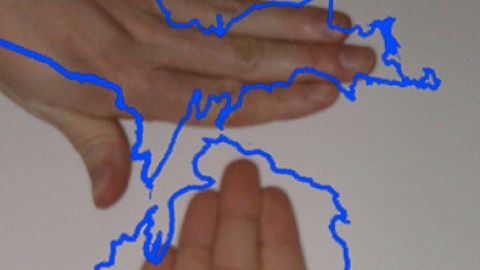
Mitte is German for middle or mid, as in Midwest, the geographical designation for 12 US states (1), one of which is Michigan. The Great Lakes State’s Lower (i.e. southern) Peninsula is often called the Mitten, not because of any German connection, but for its similarity to the fingerless glove type of that name (2). Imagine a right hand glove facing you, and Saginaw Bay is where the fingers diverge from the thumb.
The Mitten then becomes a Rudimentary Positioning System for any location in the Lower Peninsula (LP). If you live in Detroit, for example, you could point to the area below the thumb to indicate your location. For Grand Rapids, touch a spot just inwards from the middle of the Mitten’s left side… But it would be geographically more precise to ditch the mitten simile – take it off, as it were – and go two steps further.
Comparing the LP to an actual, uncovered hand allows for a much more detailed topography. Also using the other hand (3) adds the Upper Peninsula (UP). We now have the entire state laid out before us. Annoyingly, the only thing missing is a third hand, to point to all the locations this impromptu double mains map unlocks. This picture might help.

In the Upper Peninsula:
In the Lower Peninsula:
This handy map of Michigan was sent in by Krishna Kumar, who “was telling this girl about [the Strange Maps] website. Probably not the best chat-up line, but I had a reason. She uses the strangest map I’ve ever seen – her hand – to explain where she is from: Michigan […] What is truly bizarre is it seems a lot of people use this secret code to explain things.” The Michigan Hand map (this one found here) is a rare example of hand-based cartography – rare, because few cartographic entities lend themselves to hand-mapping. It is, however, not unique. Another example, detailing the Bay Area, was treated earlier on this blog (7). Should you know of further examples, whether mono- or ambidextrous, your notificiation is eagerly awaited.
Strange Maps #454
Got a strange map? Let me know at strangemaps@gmail.com.
———–
(1) The US Census Bureau divides America into 4 geographical Regions (Northeast, Midwest, South and West), and those into a total of 9 Divisions. The Midwest consists of Division 3 (East North Central), i.e. Wisconsin, Michigan, Illinois, Indiana and Ohio; and Division 4 (West North Central), being Missouri, North Dakota, South Dakota, Nebraska, Kansas, Minnesota and Iowa.
(2) Should it ever come up in conversation, the German for Mitten is Fäustling, its hypernym glove is Handschuh. You have to take off either to experience what the German language so succinctly calls Fingerspitzengefühl. This literally means finger tip feeling, and figuratively a delicate, almost intuitive sense of control. It appropriately applies here, as this Hands-On map pinpoints many more of Michigan’s shoreside communities, often well-known holiday resorts, than the rather blunt and frankly incomplete Mitten could.
(3) Hovering above the first one, dorsal side facing out, thumb down but hugging the palm, little finger pointing up but the middle three fingers bunched together. As on this map.
(4) Also known, in a remarkable case of circular topography, as the Bay of Green Bay, after the Wisconsin city that sits at the southernmost point of the bay it was named after.
(5) Menominee has the distinction of having been America’s #1 lumber producing town, of being located exactly on the 45th parallel North (halfway between the Equator and the North Pole), and of being the hometown of the last US soldier to die in the Vietnam War.
(6) You are right, commenter #2. Correction should sufficiently amend location. Also: does anyone have the official name for the main joint on the index finger? Trigger joint?
(7) A Handy Map of San Francisco (#313).
