The Enclaves and Exclaves of Cyprus
Talks are under way in Geneva to resolve the Cyprus issue. Success would mean the reunification of the Turkish north and Greek south of the island, resolving a division that has existed since 1974.Reunification of the island would dissolve the bizarre neutral zone that separates both parts of the island, one in which time seems to have stopped for over four decades. But even a unified Cyprus would not be free of territorial anomalies. The UK would still retain two enclaves on the island.

The situation today: the neutral zone in grey, Turkish Cyprus to the north of it and Greek Cyprus to the south. The British enclaves are marked in red.
Since the Turkish invasion of 1974, the island of Cyprus is divided into two main entities: an internationally recognised Greek republic in the south, and a Turkish republic of northern Cyprus, only recognised by Turkey. The situation on the ground is however a bit more complex: a UN buffer zone separates the two states, occupying an almost impenetrable swathe of territory that cuts the country (and the capital, Nicosia) in half – thus constituting a third territorial entity on the ground.
And there is a fourth entity: the British Sovereign Base, an area encompassing 254 km² in two separate areas on the southern and western coast of the island, totalling 3% of Cyprus’ land area. Great Britain as former colonial power retained these areas when Cyprus gained independence in 1960: they continue to serve as important military outposts in a sensitive area of the world – the Middle East and the Suez Canal Zone.
The complication doesn’t end there. The southern area is called Akrotiri (also known as the Western Sovereign Base Area – WSBA), the eastern area is known as Dhekelia (officially the Eastern Sovereign Base Area – ESBA). The WSBA is completely surrounded by Greek Cypriot territory, and is a fairly ‘normal’ enclave. The ESBA, however, is an ingredient in the incredibly complex territorial salad that is eastern Cyprus.

Akrotiri, a.k.a. the Western Sovereign Base Area (WSBA)
The ESBA is bordered in the south by the Mediterranean Sea, in the east and west by Greek Cyprus, in the north by the UN buffer zone and by Turkish Cyprus. It thus cuts the territory of Greek Cyprus in two parts.
This effectively makes the small area east of the ESBA an exclave of Greek Cyprus. It’s unclear how this area ‘communicates’ with the main part of the state: are there corridors through which traffic can pass unhindered by the British military?
To make matters even more complicated, this map indicates three areas inside the ESBA that are part of Greek Cyprus. These three enclaves in the ESBA are Xylothimbo, Ormidhia and a small coastal area remaining unnamed in this map. These are foreign, civilian areas inside a military base. Very impractical, to say the least. Why were these areas not included in the British Sovereign Base?

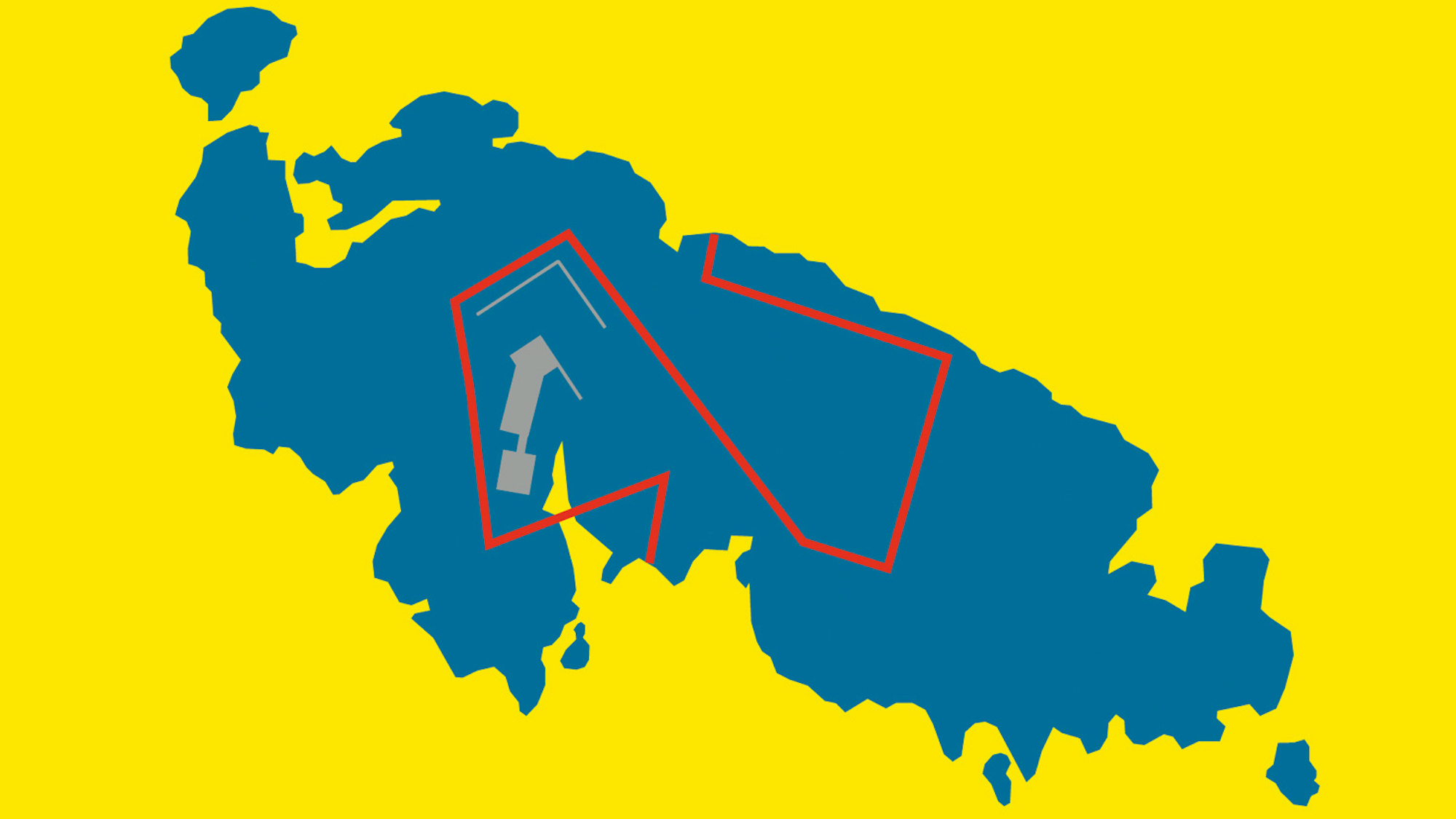
Dhekelia, a.k.a. the Eastern Sovereign Base Area (ESBA)
The third, unnamed enclave (from a British point of view; from a Greek Cypriot perspective, the area is also an exclave) is Dhekelia power station, according to Wikipedia. Its area is again divided into two by a British military road. The southern part borders the sea, but does not possess Greek Cypriot territorial waters.
The ESBA also includes an area calles Agios Nikolaos (Saint Nicholas), which in its turn is not contiguous with the main area of the ESBA. Why was this difficult territorial setup chosen?
The map seems to indicate that the sliver of land between Agios Nikolaos and the rest of the ESBA is under administration of the UN. How does traffic between these two parts work?
Conversely, there is a strip of UN territory to the east of Agios Nikolaos separating Greek from Turkish Cyprus which is not linked to the rest of the UN buffer zone. Can UN monitors pass freely through British military territory?
Agios Nikolaos seems to be the only part of the border between Greek and Turkish Cyprus which is not controlled by the UN. Is the British Army responsible for the maintenance of the cease-fire in this area?
All maps taken from the relevant Wikipedia page.
Strange Maps #33