Big ideas.
Once a week.
Subscribe to our weekly newsletter.
A Crowd-sourced Translation for a Mysterious Map Rug
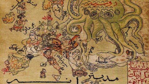
A Middle-Eastern copy of the famous 'serio-comic' map of Europe, with the female figures more modestly dressed

This rug would really tie any map-lover's room together. It is the product of two venerable map-making traditions, one eastern, the other western.
Since at least the time of the Soviet occupation (1979-'89), Afghanistan is the source of so-called 'war rugs': carpets depicting the instruments of modern warfare rather than ancient geometric patterns (see #395).
This particular rug fits into that tradition – except that it appears to be much, much older. The image it copies is one of the iterations of the famous 'serio-comic' maps that were popularised by Fred W. Rose and translated across Europe in the decades preceding World War I (See #521).
These maps showed animate versions of European nations, variously trampling, shoving and strangling each other. This rug is an almost identical copy of the Fred W. Rose map. Its main feature is Russia as an octopus, stretching out its tentacles towards Central Europe, the Balkans and the Middle East.
Spain and Portugal are recognisably cast in the same awkward position across the Iberian peninsula. France is represented by a female form rather than the moustachioed gentleman in the Rose map, but this version of Marianne seems to be wearing a Muslim headscarf rather than a Phrygian cap. The maiden representing the Austro-Hungarian Empire is no longer bare-chested, and also more modestly dressed.
This map appeared here on Reddit's Mapporn section, without further indication of source or context. Who can offer a translation for the words on the rug in Arabic script – and/or offer an indication of its provenance, age and motivation?
UPDATE (16 December 2017) – Below some more information on the content of the map/rug. Thanks all contributors!
Tom R., of Iranian descent, says the writing on the map is Persian as used before the 1950s, and suspects the map dates from 1920s Iran. “The writing in the box at the bottom corner says: Map of Europe before the war of 1914. (=1322 in the Islamic lunar calendar)”. Some other observations by Tom:
- “Although there are at least two words in Arabic on the map (بحر = sea and سنه = year) rather than their Persian equivalents (دریا and سال), I'm 100% sure the language is Persian. A large number of Arabic words were used regularly in Persian, and many still are. These two words are among those that were replaced in both spoken and written Persian by an Academy appointed by Reza Shah”. Reza Shah Pahlavi was the Shah of Iran from 1925 to 1941.
- “Two specific points that prove the language is not Arabic. One is the word نقشه (map) in the box, which is not Arabic. Second, and this can be missed easily: the Persian word for 'Norway' comes from its french pronunciation as نروژ which has as its last letter ژ which is one of four letters that do not exist in Arabic”.
- “I think the source for this map was another one than the one you've put in the post, because aside from the changes in the figures that you pointed out, the writings are not exactly equivalent either. For example: the carpet specifies the body of water between France and Britain as the 'Sea of Manche'”. The English Channel is called 'La Manche' in French – pointing to a French version of this map as the probable source for this one.
Jordan Toy concurs that the writing is in Persian, adding that “it looks like water features are in black and countries are in red”. Some translations:
- “Between France and Spain, you have Bay of Biscay (خلیج بیسکی), which looks just like it on the rug”.
- “The octopus is Russia (روسیه), which you can see in red text”.
- “The Baltic Sea is shown as بالتیک, the Adriatic Sea is shown tilted (almost upside down) as آدریاتیک”.
- “Germany is shown as آلمان”.
- “The big black script on the bottom (مدیترانه ای) means the Mediterranean”.
Philippe L. also tried his hand at translating the main elements of the map, and produced this annotated version.
He agrees that the map is in Farsi (Persian), and offers the following observations:
- “Most of the names are translations of the countries or seas. There are some capitals (London, for instance and not England)”.
- “The name for the Mediterranean derives from 'mediterranean', whereas in Egyptian Arabic it would be called the 'White Sea'”.
- “The label for Caspian Sea, the first word (بحر = bahr) means sea, while the second word looks like "خزر" (khazar). According to Arabic wikipedia, this was its name in the Middle Ages. And according to English wikipedia, it's its Turkish name as well”.
- “Spain is labelled by the name of its inhabitants ('Spanish') rather than the country name”.
- “Austria is written as 'Autrich', after the French version of the country name (Autriche), while in Arabic its name is 'Nemsa' – derived from Russian”.
Got more? Send your input to: strangemaps@gmail.com.
Strange Maps #874
Weird science shows unseemly way beetles escape after being eaten
Certain water beetles can escape from frogs after being consumed.
R. attenuata escaping from a black-spotted pond frog.
- A Japanese scientist shows that some beetles can wiggle out of frog's butts after being eaten whole.
- The research suggests the beetle can get out in as little as 7 minutes.
- Most of the beetles swallowed in the experiment survived with no complications after being excreted.
In what is perhaps one of the weirdest experiments ever that comes from the category of "why did anyone need to know this?" scientists have proven that the Regimbartia attenuata beetle can climb out of a frog's butt after being eaten.
The research was carried out by Kobe University ecologist Shinji Sugiura. His team found that the majority of beetles swallowed by black-spotted pond frogs (Pelophylax nigromaculatus) used in their experiment managed to escape about 6 hours after and were perfectly fine.
"Here, I report active escape of the aquatic beetle R. attenuata from the vents of five frog species via the digestive tract," writes Sugiura in a new paper, adding "although adult beetles were easily eaten by frogs, 90 percent of swallowed beetles were excreted within six hours after being eaten and, surprisingly, were still alive."
One bug even got out in as little as 7 minutes.
Sugiura also tried putting wax on the legs of some of the beetles, preventing them from moving. These ones were not able to make it out alive, taking from 38 to 150 hours to be digested.
Naturally, as anyone would upon encountering such a story, you're wondering where's the video. Thankfully, the scientists recorded the proceedings:
The Regimbartia attenuata beetle can be found in the tropics, especially as pests in fish hatcheries. It's not the only kind of creature that can survive being swallowed. A recent study showed that snake eels are able to burrow out of the stomachs of fish using their sharp tails, only to become stuck, die, and be mummified in the gut cavity. Scientists are calling the beetle's ability the first documented "active prey escape." Usually, such travelers through the digestive tract have particular adaptations that make it possible for them to withstand extreme pH and lack of oxygen. The researchers think the beetle's trick is in inducing the frog to open a so-called "vent" controlled by the sphincter muscle.
"Individuals were always excreted head first from the frog vent, suggesting that R. attenuata stimulates the hind gut, urging the frog to defecate," explains Sugiura.
For more information, check out the study published in Current Biology.
Moral and economic lessons from Mario Kart
The design of a classic video game yields insights on how to address global poverty.
Mario kart on giant screens
Poverty can be a self-sustaining cycle that might require an external influence to break it. A new paper published in Nature Sustainability and written by professor Andrew Bell of Boston University suggests that we could improve global anti-poverty and economic development systems by turning to an idea in a video game about a race car-driving Italian plumber.
A primer on Mario Kart
For those who have not played it, Mario Kart is a racing game starring Super Mario and other characters from the video game franchise that bears his name. Players race around tracks collecting power-ups that can directly help them, such as mushrooms that speed up their karts, or slow down other players, such as heat-seeking turtle shells that momentarily crash other karts.
The game is well known for having a mechanism known as "rubber-banding." Racers in the front of the pack get wimpy power-ups, like banana peels to slip up other karts, while those toward the back get stronger ones, like golden mushrooms that provide extra long speed boosts. The effect of this is that those in the back are pushed towards the center, and those in front don't get any boosts that would make catching them impossible.
If you're in last, you might get the help you need to make a last-minute break for the lead. If you're in first, you have to be on the lookout for these breakouts (and the ever-dreaded blue shells). The game remains competitive and fun.
Rubber-banding: A moral and economic lesson from Mario Kart
In the real world, we see rubber-banding used all the time. Welfare systems tend to provide more aid to those who need it than those who do not. Many of them are financed by progressive taxation, which is heavier on the well-off than the down-and-out. Some research suggests that these do work, as countries with lower levels of income inequality have higher social mobility levels.
It is a little more difficult to use rubber-banding in real life than in a video game, of course. While in the game, it is easy to decide who is doing well and who is not, things can be a little more muddled in reality. Furthermore, while those in a racing game are necessarily antagonistic to each other, real systems often strive to improve conditions for everybody or to reach common goals.
As Bell points out, rubber-banding can also be used to encourage sustainable, growth programs that help the poor other than welfare. They point out projects such as irrigation systems in Pakistan or Payments for Ecosystems Services (PES) schemes in Malawi, which utilize positive feedback loops to both provide aid to the poor and promote stable systems that benefit everyone.
Rubber-banding feedback loops in different systems. Mario Kart (a), irrigation systems in Pakistan (b), and PES operations in Malawi (c) are shown. Links between one better-off (blue) and one worse-off (red) individual are highlighted. Feedback in Mario Kart (a), designed to balance the racers, imprAndrew Bell/ Nature Sustainability
In the Malawi case, farmers were paid to practice conservation agriculture to reduce the amount of sediment from their farms flowing into a river. This immediately benefits hydroelectric producers and their customers but also provides real benefits to farmers in the long run as their soil doesn't erode. By providing an incentive to the farmers to conserve the soil, a virtuous cycle of conservation, soil improvement, and improved yields can begin.
While this loop differs from the rubber-banding in Mario, the game's approach can help illustrate the benefits of rubber-banding in achieving a more equitable world.
The task now, as Bell says in his paper, is to look at problems that exist and find out "what the golden mushroom might be."
A new warning to sign to predict volcanic eruptions?
Satellite imagery can help better predict volcanic eruptions by monitoring changes in surface temperature near volcanoes.
Volcano erupting lava, volcanic sky active rock night Ecuador landscape
- A recent study used data collected by NASA satellites to conduct a statistical analysis of surface temperatures near volcanoes that erupted from 2002 to 2019.
- The results showed that surface temperatures near volcanoes gradually increased in the months and years prior to eruptions.
- The method was able to detect potential eruptions that were not anticipated by other volcano monitoring methods, such as eruptions in Japan in 2014 and Chile in 2015.
How can modern technology help warn us of impending volcanic eruptions?
One promising answer may lie in satellite imagery. In a recent study published in Nature Geoscience, researchers used infrared data collected by NASA satellites to study the conditions near volcanoes in the months and years before they erupted.
The results revealed a pattern: Prior to eruptions, an unusually large amount of heat had been escaping through soil near volcanoes. This diffusion of subterranean heat — which is a byproduct of "large-scale thermal unrest" — could potentially represent a warning sign of future eruptions.
Conceptual model of large-scale thermal unrestCredit: Girona et al.
For the study, the researchers conducted a statistical analysis of changes in surface temperature near volcanoes, using data collected over 16.5 years by NASA's Terra and Aqua satellites. The results showed that eruptions tended to occur around the time when surface temperatures near the volcanoes peaked.
Eruptions were preceded by "subtle but significant long-term (years), large-scale (tens of square kilometres) increases in their radiant heat flux (up to ~1 °C in median radiant temperature)," the researchers wrote. After eruptions, surface temperatures reliably decreased, though the cool-down period took longer for bigger eruptions.
"Volcanoes can experience thermal unrest for several years before eruption," the researchers wrote. "This thermal unrest is dominated by a large-scale phenomenon operating over extensive areas of volcanic edifices, can be an early indicator of volcanic reactivation, can increase prior to different types of eruption and can be tracked through a statistical analysis of little-processed (that is, radiance or radiant temperature) satellite-based remote sensing data with high temporal resolution."
Temporal variations of target volcanoesCredit: Girona et al.
Although using satellites to monitor thermal unrest wouldn't enable scientists to make hyper-specific eruption predictions (like predicting the exact day), it could significantly improve prediction efforts. Seismologists and volcanologists currently use a range of techniques to forecast eruptions, including monitoring for gas emissions, ground deformation, and changes to nearby water channels, to name a few.
Still, none of these techniques have proven completely reliable, both because of the science and the practical barriers (e.g. funding) standing in the way of large-scale monitoring. In 2014, for example, Japan's Mount Ontake suddenly erupted, killing 63 people. It was the nation's deadliest eruption in nearly a century.
In the study, the researchers found that surface temperatures near Mount Ontake had been increasing in the two years prior to the eruption. To date, no other monitoring method has detected "well-defined" warning signs for the 2014 disaster, the researchers noted.
The researchers hope satellite-based infrared monitoring techniques, combined with existing methods, can improve prediction efforts for volcanic eruptions. Volcanic eruptions have killed about 2,000 people since 2000.
"Our findings can open new horizons to better constrain magma–hydrothermal interaction processes, especially when integrated with other datasets, allowing us to explore the thermal budget of volcanoes and anticipate eruptions that are very difficult to forecast through other geophysical/geochemical methods."
Stressed-out mothers are twice as likely to give birth to a girl
New research from the University of Granada found that stress could help determine sex.