A vertical map of Earth: How high or low can you go?
Most of our lives are spent relatively close to sea level. But Earth can be traveled in three dimensions—including up and down, from the rarefied heights of the tropopause to the crushing depths of the Mariana Trench. If you’ve flown long-distance, you’ve done the former. And that is fairly likely: at any given time, about 500,000 people are in the air. But unless you’re James Cameron, you’ve probably not done the latter. Here’s a cross-section of Earth: how high or low have you ever gone?
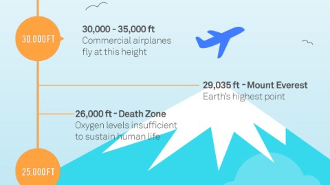
Cruising altitude of commercial airplanes (30,000–35,000 ft; 9.1-10.7 km)
The ideal cruising altitude for commercial airplanes, between 30,000 and 35,000 ft, is as high above the ground as most people are likely to get. To get any higher, you have to fly a military jet or become a full-fledged astronaut. So why do civilian planes fly this high?
First and foremost, to fly ‘above the weather’. Up until the 1950s, commercial planes could not be pressurized and were thus limited to altitudes of 10,000 ft (3 km). This forced them to fly through heavy weather, with unpleasant consequences for the passengers. Even at 28,000 ft (8.5 km)—the ceiling for the Super-G Constellation, which came into service in the 1950s—this could not be totally avoided. But once beyond 30,000 ft, there’s no more rain, snow, ice or turbulence.
Flying at this altitude brought extra advantages. For one, greater engine efficiency. Heat engines are most efficient where the air is coldest for their inlets, in this case in the tropopause—where the troposphere, the lowest layer of the atmosphere, changes into the stratosphere, which extends from around 6-11 miles (9-17 km) up to 30 miles (50 km) above the earth’s surface.
Another advantage: lower air pressure at higher altitudes means less drag, allowing the plane to develop higher speeds with greater fuel efficiency than at lower altitudes. So why not fly even higher? Because the even thinner air would deprive the wings of their capacity to generate lift, while also reducing the engine’s thrust.
One final plus of flying at great altitude: if you’re flying in the right direction, the jet stream will give the plane an extra boost, further reducing fuel spend and flight time.
Mount Everest (29,035ft; 8,849.8 m)
The world’s tallest mountain was first conquered by Sir Edmund Hillary and Tenzing Norgay in 1953. Since then, about 4,000 other mountaineers have reached the summit. However, Everest has also claimed around 250 lives in the decades since the first ascent.
The Death Zone (26,000 ft; 7,900 m)
At this elevation, atmospheric pressure drops below 356 millibars and oxygen becomes too scarce to sustain human life. Oxygen-deprivation can lead to disorientation, loss of cognitive and bodily functions, and ultimately death. Extended stays above this elevation require supplementary oxygen. There are 14 mountain summits in the Death Zone, including Everest.
Ojos del Salado (22,595 ft; 6,886.9 m)
The second-highest peak in both the Western and Southern Hemispheres (1) and the highest active volcano in the world, Ojos del Salado last erupted around 700 AD. That seems pretty long ago to be classified as ‘active’, but there is some evidence for ash emission in 1993, as well as recent fumaroles (i.e. steam or gas vents).
Ojos del Salado is in the Andes, right on the Chilean-Argentinian border. In fact, the border runs between the mountain’s two summits, which are virtually the same height. Its name is Spanish for ‘Eyes of the Salty One’, which refers to the salt deposits in the form of lagoons (or ‘eyes’) in its glaciers.
Its crater contains the highest lake in the world, at 20,960 ft (6,390 m). It was first climbed on 26 February 1937 by Polish mountaineers Jan Alfred Szczepański and Justyn Wojsznis.
La Rinconada (16,728 ft; 5,098.7 m)
The world’s highest permanent settlement has few other attractions other than its altitude record. Except for the gold, of course.
Essentially, La Rinconada in Peru is a rough-and-tumble gold miners’ camp the population of which has exploded in the first decade of this century as the price of gold has skyrocketed (+235% from 2001 to 2009).
Workers in the local goldmine work without pay for 30 days and then on the 31st day get to mine as much ore for themselves as they can.
Situated at the foot of a glacier called La Bella Durmiente (‘The Sleeping Beauty’), La Rinconada is now home to around 50,000 people but lacks municipal services such as plumbing, heating or sanitation, or a hotel for visitors.
Despite its location close to the equator, La Rinconada’s climate has more in common with that of western Greenland, with an average annual temperature of 1.2°C. La Rinconada is located 700 m higher than the next city with a comparable population, Cerro de Pasco—another Peruvian mining town.
Standard skydiving altitude (12,500 ft; 3,180 m)
The parachute was invented by André-Jacques Gamerin in 1797. He tested it by jumping out of a balloon 3,200 feet above Paris. Parachuting has since become a recreational activity, a competitive sport and a military technique for the deployment of personnel and supplies. The highest parachute jump ever was achieved on 24 October 2014 by Alan Eustace, who jumped from 135,890 feet (41,422 m).
To non-initiates, skydiving may seem scary. It’s actually fairly safe. In 2015, the U.S. Parachute Association recorded just 21 fatalities out of a total of around 3.5 million jumps, which translates to a 0.006% chance of death while skydiving. According to the statistics of the National Safety Council, you’re more likely to die from being struck by lightning or stung by a bee—or from driving to and from the drop zone.

Mount Fuji (12,389 ft; 3,776.2 m)
More than just the highest mountain of Japan, Mount Fuji is also one of the country’s three holy mountains (2) and an important national symbol. It’s often been depicted in Japanese art and has figured on stamps and banknotes.
An active stratovolcano with a remarkably symmetrical cone, Mount Fuji can be seen from as far as Tokyo, 60 miles (100 km) to the northeast. It last erupted in 1707-’08, raining cinders and ash on the surrounding area. The eruption formed a second peak halfway down the southeastern side, named Mount Hōei.
The first ascent is ascribed to the semi-mythical monk Otsuno, in 663 AD. The first non-Japanese person to reach the summit was Sir Rutherford Alcock, in September 1868. Women were forbidden to climb the mountain until the late 1860s. Possibly the first one, and certainly the first non-Japanese woman to do so was Lady Fanny Parkes, the wife of the British ambassador, in 1869.
With more than 200,000 people climbing to the top each year, Mount Fuji is a major tourist attraction. The mountain is often climbed at night, in order to witness the sunrise at or near the summit. According to a Japanese saying, a wise person will climb Mount Fuji once in his life, but only a fool would climb it twice.
The Aokigahara Forest, at the northwest base of the mountain, has a grisly reputation. In olden days, poor families abandoned their very young and very old here. Today, the Forest is the world’s second-most popular suicide location, after San Francisco’s Golden Gate Bridge.
Ben Nevis (4,409 ft; 1,343.9 m)
The highest mountain in Scotland, and the British Isles. Its name, a translation from the original Gaelic, either means ‘venomous mountain’, or ‘mountain with its head in the clouds’.
Its summit is the collapsed dome of an ancient volcano which blew up some 350 million years ago. Only in 1847 was Ben Nevis confirmed as the highest mountain in Britain and Ireland, over its rival Ben Macdhui.
The first attested climb to the top was on 17 August 1771 by James Robertson. In 1895, William Swan became the first person to run up the mountain, making it to the top and back to the old post office in Fort William in two hours and 41 minutes.
The Ben Nevis Race in its current form takes place every first Saturday of September. The current record times were both set in 1984, with Kenny Stuart running it in 1 hour, 25 minutes and 34 seconds, and Pauline Haworth in 1 hour 43 minutes and 25 seconds.
Currently, around 100,000 people each year climb the mountain. At the summit, they see the ruins of an observatory annex hotel that operated from 1883 to 1904. On a clear day, they can see all the way to Barra Head in Northern Ireland.
The next highest mountains are in western Norway, more than 400 miles (640 km) away. Two other peaks were named after Ben Nevis: a 3,025-ft (922-m) high mountain on the Norwegian archipelago of Svalbard, and a 1,604-ft (489-m) hill in Hong Kong, now known as Hung Fa Chai.
Burj Khalifa (2,717 ft, 828.1 m)
Since its completion in 2009, Burj Khalifa in Dubai has taken over from Taipei 101 in Taiwan as the world’s tallest building, and from the Warsaw Radio Mast in Poland as the world’s tallest man-made structure. Other records include building with most floors (211), longest distance traveled by elevators (1,654 ft; 504 m), and world’s highest restaurant (122nd floor) and nightclub (114th floor).
The spire alone is 800 ft (244 m) tall, and widely considered ‘vanity height’, since it contains very little usable space. On its own, it’s taller than all but 10 of the skyscrapers in Europe. At its top, the spire sways a total of 4.9 ft (1.5 m).
The tower has two outdoor observation decks: At The Top, on the 124th floor, at 1,483 ft (452 m); and SKY level on the 148th floor, at 1,821 ft (555 m). Both were the highest outdoor observation decks when they were inaugurated, but each was surpassed by a Chinese rival. Under ideal circumstances, the view from the top goes all the way to Iran, across the Gulf.
Shanghai Tower (2,073 ft; 631.8 m)
The Shanghai Centre Tower may just be the world’s second-tallest building, but it does have the world’s highest observation deck, on the 118th floor (and, at a top speed of 20.5 m/sec or 46 mph, the world’s fastest elevators). It is flanked by two further super-tall buildings: the Jin Mao Tower and the Shanghai World Financial Centre. Such proximity of super-tall buildings is also a world first.
The Shard (1,004 ft; 306 m)
Opened in February 2013, The Shard—95% of which is owned by the State of Qatar—is the tallest building in the U.K. and the European Union. It is not, however, Europe’s tallest building (as the map claims): three taller buildings overlook Moscow, the tallest one being the eastern tower of the Federation Towers, at least until the completion of the Lakhta Tower in St Petersburg, later this year.
Designed by Renzo Piano, The Shard has 95 storeys, 72 of which are habitable. There is a viewing gallery and an open-air observation deck on the 72nd floor, at 801 ft (244 m). In February 2011, a fox was discovered living on the then still partially completed 72nd floor. Nicknamed ‘Romeo’, it was rescued and released back in the wild, no doubt with stories to tell to its fellow foxes.
Bingham Canyon Mine (3,182 ft; 970 m)
A.k.a. Kennecott Copper Mine, this open-pit copper mine in Utah is the largest man-made excavation in the world and is visible from space. In operation since 1906, the mine has produced a pit over 0.6 miles (970 m) deep, 2.5 miles (4 km) wide, and covering 1,900 acres (770 ha).
As yet, it has produced 19 million tonnes of copper, more than any other mine in history. The value of the resources extracted (not just copper, but also molybdenum, silver and gold) at the Bingham Canyon Mine exceed those of the Comstock, Klondike and California Gold Rushes combined.
Depth of Grand Canyon (6,000 ft; 1,800 m)
Not that far from the Bingham Canyon Mine, the Grand Canyon isn’t actually below sea level either. “In fact, the bottom of the Grand Canyon is about 1,850 ft (560 m) above sea level”, the graph’s legend reads. “We’ve included it in the infographic to help highlight the sense of scale”.
Cuvier’s Beaked Whales (10,000 ft; 3,000 m)
Whales are mammals, so they can’t breathe underwater. Before they dive, they take a gulp of air at the surface and then go under—in the case of Cuvier’s beaked whales, up to 10,000 ft deep. That’s a lot farther down than sperm whales, which have been known to dive only as deep as 7,300 ft (2,225 m). To go that distance and come up for air again, Cuvier’s beaked whales have to hold their breath for a very long time. The longest recorded interval between surfacings is 2 hours and 17 minutes.
Wreck of the RMS Titanic (12,500 ft; 3,810 m)
The RMS Titanic is arguably the most famous shipwreck in history. The ‘unsinkable’ giant luxury cruiser sank on 15 April 1912 on its maiden voyage from Southampton in England to New York City, after striking an iceberg.
The wreck was not discovered until September 1985. It rests on the seabed of the North Atlantic Ocean, about 370 miles (600 km) southeast of Newfoundland, at a depth of about 12,500 feet, or 2.37 miles (3,800 m). The hull is broken in two, with the pieces lying about a third of a mile (600 m) apart, amid a field of smaller debris.
Several proposals to raise the wreck proved impractical, among other factors because of its great depth. Numerous dives have been organized since the wreck’s discovery, some of which have salvaged items from the ship. This practice splits those concerned into two camps: ‘conservationists’, who feel it’s defensible to rescue as many artifacts as possible from deep-sea oblivion; and ‘protectionists’, who want to maintain the integrity of the site as a memorial to the dead.
It has been estimated that the wreck could collapse as soon as 2025 and could be completely gone by 2037, due in large part to a species of rust-eating bacteria which was first discovered on the Titanic site itself. In 1995, director James Cameron made 12 dives to Titanic, resulting in footage used for his 1997 film Titanic.
Mponeng & TauTona Gold Mines (12,800ft; 3,900 m)
Mponeng and TauTona, both in South Africa’s Gauteng province, are the deepest gold mines in the world. Both are dangerous places to work: airconditioning is required to keep temperatures survivable, and each year, several miners die in accidents.
Mponeng extends about 2.5 miles (4 km) below the surface. Every day, 4,000 workers descend through triple-decked elevators which hold 120 people at the same time. It takes six minutes to descend the first 1.6 miles. The trip from the surface all the way to the bottom of the mine takes over an hour. Mponeng contains at least two gold reefs. Each day, over 5,400 metric tonnes of rock are extracted. To stay profitable, the mine needs to recover just 10 grams of gold per ton.
TauTona reached its current depth, approximately 2.4 miles (3.9 km) when it inaugurated a new shaft in 2008. The mine employs around 5,600 miners and has some 500 miles (800 km) of tunnels.
KTB Borehole (30,000 ft; 9,191 m)
KTB stands for Kontinentales Tiefbohrprogramm der Bundesrepublik Deutschland. In plain English: German Superdeep Hole. The project, located in Windischeschenbach in Bavaria, was conceived to study the effects of stress on layers of rock, abnormalities in the earth’s crust, and how heat and stress were conducted through it.
The location was chosen because it’s where the former continents of Laurasia and Gondwana merged into Pangaea. Drilling started in 1987 and continued to 1994 when depths of 30,000 ft (9,191 m) and temperatures of 265°C were reached. The derrick is one of the largest in the world and is a tourist attraction. Two smaller boreholes were kept open for further research.
Deepwater Horizon (35,055 ft; 10.7 km)
In 2009, the Deepwater Horizon drilled the deepest oil well in history, at a vertical length of 35,055 ft (10.7 km), in the Gulf of Mexico. On 20 April 2010, an explosion on the rig killed 11 crewmen and ignited a fireball visible from 40 miles (64 km) away. The resulting fire could not be extinguished and two days later Deepwater Horizon sank, leaving the well gushing at the seabed and causing the largest offshore oil spill in history.
Deepest Solo Submarine Dive (35,787 ft; 10.9 km)
James Cameron (yes, him again) in 2012 set the record for deepest solo dive in a submarine, diving in the Mariana Trench. The effort was made into a film titled Deepsea Challenge, after the name of his vessel.
Mariana Trench (36,201 ft; 11 km)
Located east of the Philippines and north of New Guinea in the western Pacific Ocean, the Mariana Trench, a half-moon-shaped scar in the earth’s crust, is the deepest natural place in the world.
The Trench reaches its maximum depth in a small valley at its southern end known as the Challenger Deep. If Mount Everest were measured from the bottom of the trench, it would still be more than a mile (1.6 km) under water. Few animals can survive at these depths, where water pressure is more than 1,000 times the standard atmospheric pressure at sea level.
Curiously, the bottom of the Mariana Trench is not the closest bit of the earth’s surface to its center. This is because the earth is not a perfect sphere: it is flatter at the poles, which means parts of the Arctic seabed are at least 13 km (8 mi) closer to the center of the earth than the seabed at Challenger Deep.
The Sakhalin-I Project (37,318 ft; 11.3 km)
Since 2003, a commercial consortium called Sakhalin-I has been exploring gas and oil deposits below and immediately offshore of Sakhalin Island in Russia’s Far East. The consortium has since conquered six of the 10 top spots in the ranking of longest drilling wells in the world.
In August 2012, the Z-44 Chayvo well reached a measured total length of 40,604 ft (12.3 km), making it the longest well in the world. That is a higher number than mentioned on this map, which has 37,318 ft down as the longest well.
This does not mean that Sakhalin now holds the record for the deepest artificial point on earth, as ‘longest’ boreholes don’t have to go straight down. The record for ‘deepest’ borehole is in Russian hands too, anyway.
The Kola Superdeep Borehole (40,230 ft; 12.3 km)
Located in Zapolyarny, about 100 miles northwest of Murmansk, the Kola Superdeep Borehole (in Russian: Kolskaya Sverkhglubokaya Skvazhina) was a Soviet scientific drilling project. From 1970, the Soviets attempted a ‘reverse moonshot’: to bore a hole in the earth’s crust deeper than anyone else had ever done.
The main target was set at 49,000 ft (15 km). By 1979, the Soviets had broken the record held by the Bertha Rogers hole in Washita, Oklahoma, at 31,440 ft (9.6 km). In 1989, borehole SG-3 reached a depth of 40,023 ft (12.3 km). The heat at that depth – around 356 °F (180°C) – made further progress impossible.
The 9-in (23-cm) wide hole has held the record of world’s deepest borehole ever since. In 1995, after the dissolution of the Soviet Union, the borehole was welded shut and the site closed off as an environmental hazard.
Strange Maps #893
Got a strange map? Let me know at strangemaps@gmail.com.
(1) behind the Aconcagua in Argentina, at 6,961 m (22,838 ft) the world’s highest mountain outside Asia.
(2) the other two being Mount Tate and Mount Haku.