Postcard from a Future Without Germany, Circa 1914
The conflict that erupted in 1914 was a World War not just because it was global, but also because it was total. On both sides, propaganda fueled the fear that defeat would mean being wiped off the map. Literally, as this German propaganda postcard shows.
Proving that no propaganda is more effective than the enemy’s own words, it reproduces the cover of a French book, published in 1913 in Paris. Its title: Le partage de l’Allemagne – L’échéance de demain (The Division of Germany – Our Goal for Tomorrow). The point is driven home by the German phrase at the bottom of the postcard: How the French, English and Russians divided our Germany even before the Declaration of War.
This is brilliant propaganda of the two-birds-with-one-stone variety: it absolves Germany of responsibility for the conflict, and stiffens its resolve to fight on, in the face of the massive casualties at the front, as well as terrible hardship on the home front. For the alternative to the Endsieg (Germany’s final victory) would be the disastrous dismemberment of the Heimat as shown on this map.

Image: Frank Jacobs. Picture taken at Bryars & Bryars, with kind permission.
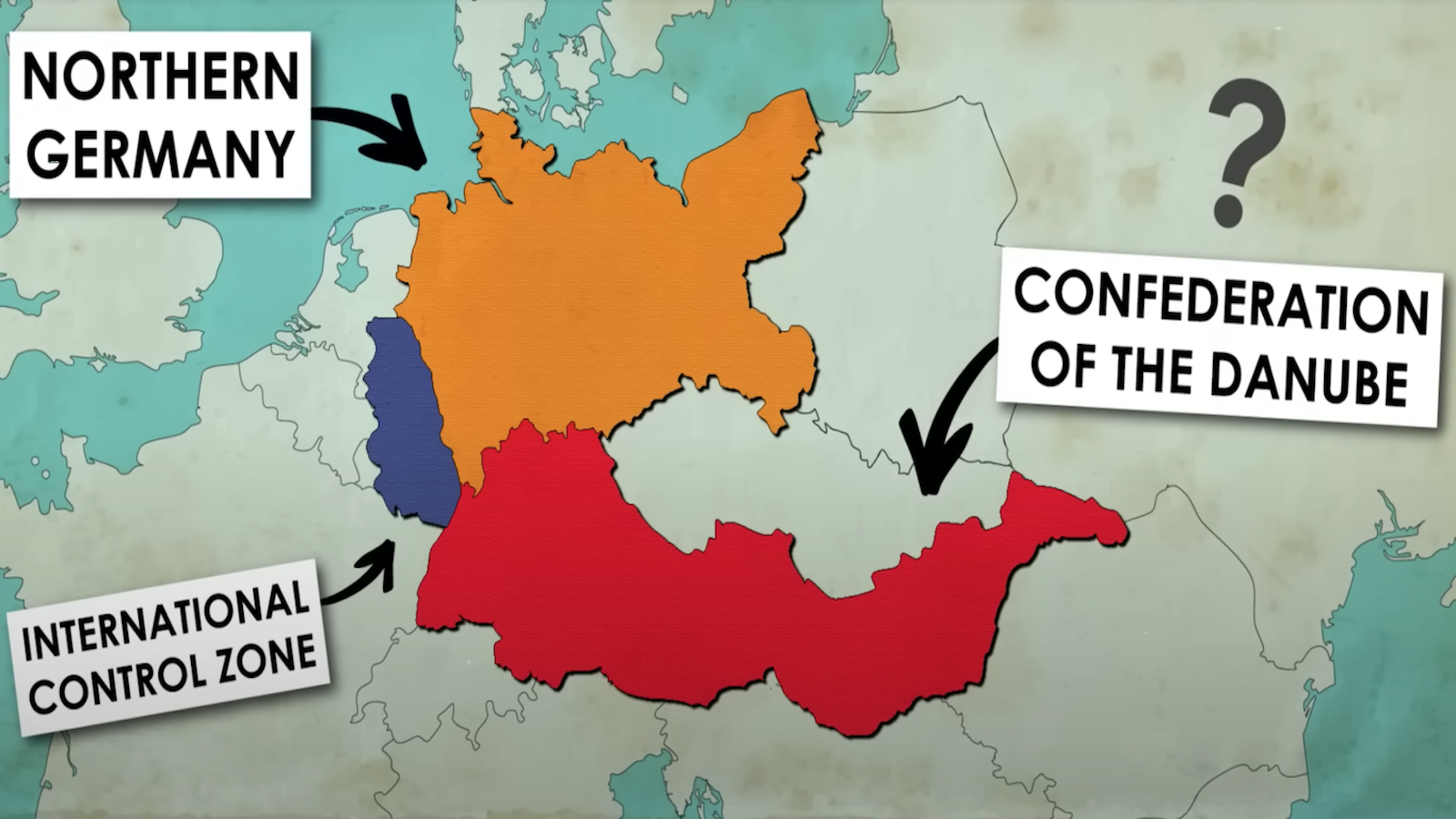
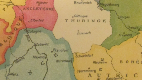
• From the north, Denmark reaches deep down all the way to Magdebourg, along the way annexing Hambourg, Brème and Lunebourg (to add insult to injury, all cities on the map are represented in their French spelling).
• Denmark gets a new neighbor: Imperial Russia, its westward thrust halting only at the Elbe, henceforth marking the Danish-Russian border. Berlin, Dresden, Torgau and other ancient German cities now owe allegiance to the Tsar rather than the Kaiser.
• In 1913, Austria was still an empire in its own right. Rather than collapsing after the war, as it did in real life, it retains Bohemia (part of independent Czechoslovakia after 1918) and gains Bavaria, adding fabled cities such as Munich, Nuremberg and Schweinfurt to its holdings.
• The Austrian emperor also gains a new neighbor – France. The French move up the Rhine all the way to Cologne, and cross the river as far east as Würzburg, also annexing Freiburg, Stuttgart and Frankfurt.
• Even plucky little Belgium gets part of the spoils: a curious, northeastern tail of territory, just east of the Dutch Limburg salient and mirroring its southward jut. Nothing for the Dutch, though. The Franco-Anglo-Russian conspiracy accurately foresaw that the Netherlands would sit this conflict out. However, after suffering at the hands of the Germans in the next one, the Netherlands did launch some claims for territorial compensation of her own (see #65).
• In this plan, the northwestern part of Germany, next to the Dutch border, becomes the continental toehold of the United Kingdom, turning this part of Lower Saxony into LowerAnglo-Saxony.
• In their magnanimity – or perhaps because the French and Russians felt safer with a buffer state in between them – the anti-German schemers have left the central part of Germany independent as the state of Thuringia.
The French book on which this German propaganda is based is a measure of just how vicious the international atmosphere was in pre-1914 Europe. The assassination of Franz Ferdinand may have been the random event that set in motion the mechanics of war, but the great continental powers had been on a collision course for decades.
Even in their bitter opposition to each other, the great nations of Europe copied and stole from each other – not just speeding up the arms race, but also the raising the stakes in the propaganda war. Hence the great success, and the many national variants of Fred W. Rose’s Serio-Comic War Map of 1877 (see also #521).
The propaganda race also, fascinatingly, produced an exact mirror image of this French map used for German propaganda in World War One – a supposedly German map used by French propaganda to frighten the people on their side of the trenches into thinking Berlin had plans for a Grande Allemagne, reaching from the Spanish to the Finnish border, wiping France off the map.

Image in the public domain. Discussed earlier in #9.
The use of territorial annihilation as a perverse incentive for the home front would recur in the Second World War, much along the lines set out in the First one, when Nazi propaganda made the most of similar proposals emanating from the Allied side (see #50 and #337).
This 1913 map appears in The History of the 20th Century in 100 Maps, by Tim Bryars and Tom Harper. Published in the UK on 9 October, it’s the first book to review the previous century entirely via the medium of cartography.
Strange Maps #690
Got a strange map? Let me know at[email protected].