EU Deletes UK from Official Map – Two Years Before Brexit
This could be the first official map produced by the European Union to exclude the UK. But it is also an inaccurate one: the UK is still a member state of the EU.
Brexit means Brexit: on 29 March, British Prime Minister Theresa May officially notified EU Council President Donald Tusk of Britain’s intention to leave the European Union.
But Britain hasn’t left yet. By invoking Article 50 of the Treaty of Lisbon, May triggered a process that gives both sides two years to reach an agreement. Meaning that Britain is scheduled to leave the EU on 29 March 2019. Until that time, the United Kingdom remains a full member of the European Union.
It is no secret that hardline brexiteers would rather leave today than tomorrow, and ‘crash out’ of the EU, even if that means falling back on the most rudimentary of agreements for trade and cooperation with ‘EU27’ – shorthand for the EU minus the UK.
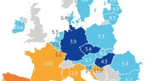
Now it seems that sentiment is reciprocated in the highest circles of the EU bureaucracy in Brussels. See the Reflection Paper on the Social Dimension of Europe (1), published by the European Commission on 26 April 2017. On page 9, it contains a telling map of the European Union.

The map shows the unemployment rates of the member states – and the stark differences for those rates between member states in the north and south of the Union. But the eye is immediately drawn to the land mass of the United Kingdom: coloured not in the blues or oranges that indicate unemployment rates in the EU, but the grey of the non-member states that dot the map.
Those non-members include the usual suspects: Iceland, Norway, Switzerland, Andorra, Albania and five of the seven post-Yugoslav states (Bosnia, Serbia, Montenegro, Kosovo and Macedonia; Slovenia and Croatia have acceded to the EU). Squeezed between Poland and Lithuania is the Russian exclave of Kaliningrad. Russia proper and other countries in eastern Europe, the Middle East and North Africa are whited out.
The UK now joins the grey countries on the map. But this is not a map produced to satisfy the wishful thinking of those hardline Brexiteers who can’t wait for 2019. This is an official publication of the European Commission, one of the highest institutions of the European Union. Despite the fact that, for almost two more years, the EU still includes Britain.
Map found on Bruno Waterfield’s Twitter feed.
Strange Maps #836
Got a strange map? Let me know at[email protected].
(1) As pointed out by a reader of this blog, the Reflection Paper deals explicitly with the future of the EU without the UK, hence the exclusion of Britain from the Union, both in the stats and on the map. This was not mentioned in an earlier version of this article – not to inflame sentiments against the EU, but to focus on the fact, remarkable in itself, that an official EU publication has published a map of the Union without Britain, possibly for the first time, and almost two years before Brexit actually happens.