America’s Deadliest Highways
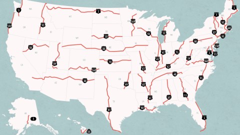
America’s deadliest highway is the 545-mile stretch of U.S. Route 1 that shadows Florida’s Atlantic Coast, running all the way from the Georgia state line to Key West. It is the highway with highest number of crashes (1,011 in the past 10 years), the highest number of fatalities (1,079 in the same period) and the highest crash rate (2.8 deaths per fatal crash) in the nation.
Data this depressing shouldn’t look this good. But Geotab, a fleet management software and vehicle tracking device supplier, has produced a road map of the deadliest highways in each state that is like a car crash – very hard to look away from.

Driving is part of the American way of life. Unfortunately, it is also a large part of the American way of death. Each year, more than 30,000 people are killed in road accidents in the United States. The National Transportation Safety Board (NTSB) is the U.S. Federal agency that investigates individual traffic accidents. The agency asked Geotab to produce a more systematic, historical overview.
Geotab used federal highway data for the past 10 years and its own expertise and software to create an overview of the most dangerous highway for each state. The overview map gives a good idea of which highways to avoid on multi-state trips:

→ The deadliest highway in the country is the Florida stretch of US Route 1. Running 2,369 miles (3,813 km) from Fort Kent on the Canadian border to Key West, it is the longest north-south road in the U.S. It is also the deadliest highway in two other states it traverses: Maine (fatal crash rate 0.7, 89 crashes, 99 deaths) and Maryland (fatal crash rate 0.7, 118 crashes, 135 deaths). The I-40 and the I-80 are the deadliest route across three connecting states each, the I-95 is the most lethal road in both Carolinas, and in Connecticut.
But there is more: at the bottom of the page, the most dangerous highways per state are ranked for three criteria: fatal crash rate, number of crashes and most fatalities.

→ The other deadliest highways in absolute numbers over the past 10 years were the I-40 in Tennessee (517 fatalities), the I-40 again in New Mexico (395 fatalities), the I-65 in Alabama (389 fatalities) and Highway 90 in Louisiana (295 fatalities).
→ The top five for fatal crash rate is quite different: second comes Highway 83 in Texas (2.0), followed by the I-40 in California (1.8), again the I-40 in New Mexico (1.6) and the I-80 in Wyoming (1.4).
→ The highway with the lowest fatality rate is the I-95 in Rhode Island (0.1). The one with the least crashes and the least fatalities is Alaska Route 3 (32 crashes and 38 fatalities over the past 10 years). That doesn’t mean these routes are safe; they are still the most dangerous highways in their respective state. They are just safest compared to all the other states’ highways.

→ The clickable overview provides interesting anecdotes per highway. For example: US-2 in North Dakota passes the geographical centre of the U.S.; Pennsylvania’s I-80 serves no major cities, and mainly serves as a link between Ohio and New York; US-61 is also known as the Blues Highway because it connects places with a blues music link; and in 1967, actress Jayne Mansfield was killed on the Louisiana stretch of Highway 90.
But of course the data collected by Geotab serves a serious purpose – to highlight the daily tragedy that are traffic fatalities – over 82 per day in the U.S. Awareness, as raised by this map, is one way of countering the deadly tide.

Map found at the Features section of the Global Fleet website – registration required. For the interactive feature itself and a little bit more on methodology, check this page atGeotab.
Strange Maps #839
Got a strange map? Let me know at [email protected].