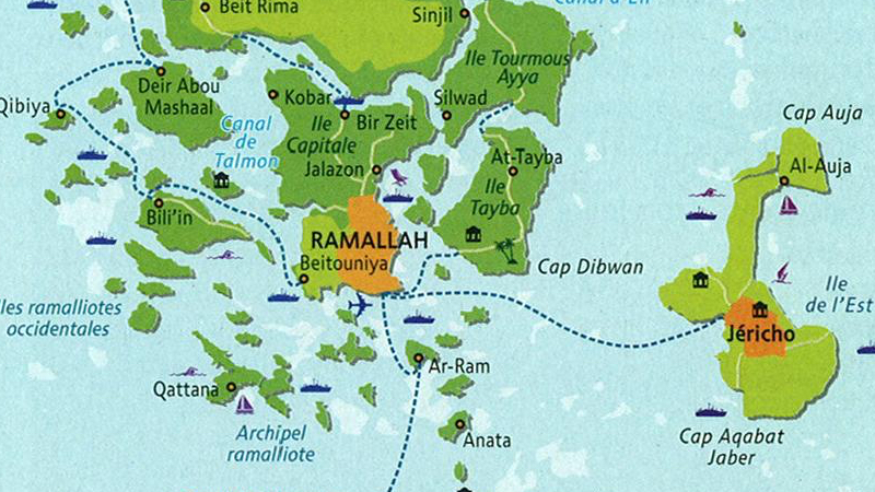
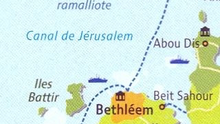
367 – Bethlehem to Ramallah by Boat

This map excerpt of the environs of Jerusalem is strangely reminiscent of this one, showing Belgium partially submerged along ethnic lines. Both maps solve the seemingly intractible disputes inherent in their human geography by flooding out the “other”.
The full map is entitled Un monde à l’envers (‘An Inverted World’) and can be found on page 129 of the 2009 edition of the Atlas du Monde diplomatique. It imagines the Palestinian areas, divided and separated by Israeli settlements, checkpoints and barriers, as an actual archipelago.
The excerpt shows Bethlehem as a coastal town on Holy Island, connected by ferry to Ar-Ram and Ramallah to the north, across the Jerusalem Canal. Other marine features on this map are Cape Elzariya and Cape Dibwan, the Ramalliot Archipelago and the Western Ramalliot Islands (both named, presumably, after Ramallah).
The aforementioned Atlas is a publication of Le Monde diplomatique, the French monthly magazine for world affairs. It might not be incidental to note that the editorial line of “Le Diplo” (as it is often called) is altermondialiste.
Altermondialism (or alter-globalisation) seeks to counteract the negative effects of an economic globalisation seen as too Anglo-Saxon and neo-liberal. But it also automatically rhymes with other political viewpoints, usually left-leaning, and in the conflict between Israelis and Palestinians mainly sympathetic to the latter. Which might explain why this map resolves that particular conflict by submerging the former.
Many thanks to Olivier, Baptiste Hautdidier, Valéry Didelon and Jacques Lantier for sending in this map, found on this page of Guerre ou Paix, a (French-language) blog dedicated to Israeli-Palestine relations.