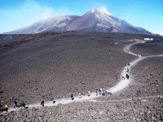
Behold Sicily’s Mount Etna — its volcanic summit is the world’s only decipoint
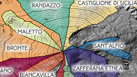
Image courtesy of Patrick McGranaghan
- For millennia, Etna has been Europe's most active volcano.
- The Sicilian mountain is also the world's only decipoint.
- Ten municipalities meet at its summit — at least on a map.
Etna’s summit is surrounded by a vast moonscape, ‘refreshed’ by frequent eruptions
Image: Hein56didden / CC BY-SA 3.0
Geological hotspot
Mount Etna, in eastern Sicily, almost never sleeps. It’s Europe’s most active volcano and has been for millennia. For the ancient Greeks, it was the location of the mythical forges of Hephaestus, the god of blacksmiths.
Etna is Italy’s highest peak south of the Alps, although the exact height of its summit (currently 10,912 ft, or 3,326 m) varies due to eruptions. Covering an area of 459 sq mi (1,190 km2), it’s also the largest of Italy’s three active volcanoes (the others being Vesuvius and Stromboli). That gives the locals a lot of room to play cat and mouse with its destructive lava flows.
A string of towns garland Etna, its inhabitants attracted by the volcanic debris that crumbles into fertile soil for the orchards and vineyards on its lower slopes. But Etna takes as well as it gives. Over the centuries, many of those towns have been destroyed again and again by the restless mountain.
But Etna is not just a geological hotspot, it’s also a unique place on the map. Zoom in, and you see a bunch of lines converge on its summit. The very tip of Mount Etna is the meeting point of ten Sicilian municipalities. That makes it the only decipoint in the world.

The bizarre territorial fragment of Neutral Moresnet on an early-20th-century postcard.
Image: public domain
‘Four Countries Point’
To provide a sense of how rare that is, imagine this: there are hundreds of international tripoints in the world – places where the borders of three countries meet. But increase the number of countries by one, and that number falls to… zero.
That’s right, there are no international quadripoints in the world, although for a hundred years, the world did have one. At the Vierlandenpunt (‘Four Countries Point’) in Vaals, the Netherlands, Germany, Belgium and Neutral Moresnet met (see also #41). But the latter territory was abolished after World War I, reducing Vaals to a rather workaday Drielandenpunt.
In the current geopolitical landscape, one other point comes close: at the eastern tip of Namibia’s Caprivi Strip, where it borders Zambia and Botswana, about 200 meters in the Zambezi River separate Namibia from Zimbabwe. But for that distance, the river would contain the world’s only current international quadripoint.

In the middle of nowhere, four states meet
Image: Phil Konstantin / CC BY-SA 3.0
Middle of nowhere
Go down an administrative level, and of course you have the famous Four Corners – the meeting point of the U.S. states of Utah, Colorado, New Mexico, and Arizona. The monument, in the middle of nowhere, provides you with the opportunity of standing in four states at the same time — though, for some (who shall remain nameless), that thrill does not outweigh the long desert ride to get there.
It’s the only such state-level point in the U.S. At lower administrative levels, quadripoints are not that rare; but again: add a number and the numbers drop vertiginously. The U.S. has only one county-level quintipoint, for example: the middle of Lake Okeechobee in Florida is where Okeechobee, Palm Beach, Hendry, Glades, Okeechobee and Martin counties meet.

Mount Etna – a natural and cartographic wonder
Image courtesy of Patrick McGranaghan
Only one in the world
Double that figure, and there’s only one point like it in the world: the summit of Mount Etna. As this map shows, 10 communes reach out to touch the top of the mountain (and each other). Here’s a brief description of each, clockwise from top:
- Randazzo (population 11,000) is a municipality in two parts: the main one touching the summit of Etna, and a large exclave called Spanò (on the left of the map, also in green). Up until the 16th century, the city was trilingual, with Greek spoken in the San Nicola district, Latin in Santa Maria and Lombard in San Martino.
- Castiglione di Sicilia (pop. 3,000) is listed as one of Italy’s most beautiful towns. When Arabs ruled the region, they raised crocodiles in the nearby Alcantara River. Following the Allied landing in WWII, Castiglione di Sicilia was the first town in Italy to be looted by the retreating Germans, who also massacred 16 locals.
- The small town of Sant’Alfio (pop. 1,500) is famous for the fine, dark wine produced by its vines; and for the Chestnut of a Hundred Horses, a tree up to 4000 years old. It derives its name from the legend that its ample crown once sheltered Queen Joan of Anjou and a hundred of her knights during a storm.

View of Castiglione di Sicilia
Image source: Salvo Curcuruto / CC BY-SA 2.0
Holiday destination
- Known as the “Pearl of the Etna,” Zafferana Etnea (pop. 10,000) is located halfway between the summit and the sea, its cool climate making it a favorite holiday destination on hot summer days. The name most likely derives from the cultivation of saffron in the area.
- Because of its strategic position between the sea and the summit, Nicolosi (pop. 7,500) is known as the Porta dell’Etna. The town’s name probably comes from that of the Benedictine monastery of San Nicoló, one of many built in the area. The earliest one, San Leone, was buried by lava in the mid-16th century.
- Belpasso (pop. 28,000) is home to Etnaland, the largest waterpark in southern Italy; and Etnapolis, Italy’s fifth-largest shopping center. Rebuilt in 1694 in a grid of straight streets, it is known as the “chessboard of the Etna.”
- Biancavilla (pop. 23,000) was founded in the late 15th century by Albanians fleeting Ottomans. A marian icon brought over by the original settlers is still venerated by the townspeople. The presence of opposing mafia clans contributes to the relatively high local crime rate.

Lava flow from Etna during an eruption in January 2011.
Image: Cirimbillo / CC BY-SA 3.0
The Thunderer
- Adrano (pop. 35,000 inhabitants) was founded around 400 BC by Dionysus, the Greek tyrant of Syracuse. A Saracen bridge and a Norman castle testify to the town’s varied history.
- Bronte (pop. 19,000), 10 miles (16 km) from Etna’s summit, is named after ‘the Thunderer’, one of the cyclopes from Greek mythology said to live under the volcano. In 1799, Britain’s admiral Nelson was created Duke of Bronte by King Ferdinand III of Naples, in gratitude for his help in suppressing a revolution and recovering Ferdinand’s throne
- Almost entirely surrounded by Bronte, the little town of Maletto (pop. 4,000) touches eight other municipalities via the decipoint at Etna’s summit. Its origins date back to a castle built in the 13th century by Manfredi Maletta, a relative of Emperor Frederick II. For the three-day Strawberry Festival held each June, the locals produce a giant strawberry cake of over a thousand kilos.

A number of territorial claims converge on the South Pole
Image: Lokal_Profil / CC BY-SA 2.5
Another decipoint?
Due to Maletto’s semi-enclaved situation, you could argue that not 10 but 11 separate territorial units meet at Etna’s summit. Either way, it’s a lot. The reason for this unique situation is the active volcanic state of the mountain. This renders the summit and large areas around it virtually impassable. Yet municipal authority, like nature itself, abhors a vacuum. So the surrounding towns set their limits not where their houses or fields end — those limits would be variable anyway, due to the vagaries of the mountain — but at the furthest possible point: the mountain’s top.
Some will say that a similar situation occurs at the South Pole, where various, partly overlapping claims have also created a decipoint. But since the Antarctic Treaty of 1961 has effectively frozen all territorial claims in Antarctica, that decipoint at the bottom of the world is a decidedly theoretical one. To visit the world’s only “live” one, climb the roof of Hephaestus’s forge, and pray he’s not about to beat on his anvil.

Decipoint map reproduced with kind permission of Patrick McGranaghan.
Strange Maps #992
Got a strange map? Let me know at [email protected].