Google Earth: From Security Threat to International Asset
When Google unveiled its innovative, if voyeuristic, satellite photo tool to the computer-loving public, it was revolutionary, it was compelling, it was intriguing, it was… a major threat against national security. But now that the world has either forgotten or simply resigned itself to (depending on who you ask) the Google Earth security threat, the application has become a vital new tool around the world.
When people started exploring Google’s geographical software upon its release in 2005, it was primarily a novelty tool that allowed you to view satellite images of your favorite locales. But by 2007, major reservations were being voiced about how Google Earth could become a valuable asset to terrorist organizations like Al Qaeda. American intelligence admitted that Google Earth’s commercial imagery could be used to help combat troops. But word had also circulated about how the Islamic Army in Iraq had been teaching its followers how to target American military targets using Google Earth. According to other press reports, Google Earth was also used to plot an unsuccessful 2006 Yemeni oil facility bombing while Google Earth images have been found in Al Qaeda safe houses. When asked by Reuters about Google Earth as a security threat in 2007, U.S. Air Force intelligence head Lt. Gen. David Deptula said “It is huge. It was something that was a closely guarded secret not that long ago and now everybody’s got access to it.”
While the New York Times reported that the Pakistani military was using Google Earth to locate specific targets, civilians are finding new uses for Google Earth. In the past couple of years, Google Earth has launched a number of important extensions of the application. One allowed users to view a live hectare ticker indicating the rate of deforestation all over the planet. In another, Google Earth partnered with the U.S. Holocaust Memorial Museum to show in great detail the scope of the destruction in Darfur. The “Crisis in Darfur” layer even offers before and after images of roughly 200 locations that were ravaged by the war. While Google Earth has become a more important social tool, it’s also made surveillance more accessible to everyday people.
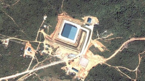
Last month, Google Earth helped retrieve a historic German bomber that had vanished after being shot down in 1941. Plagued by a major housing shortage in Bahrain, the local Shiite majority took to Google Earth to survey the immense palaces housing the Khalifa royal family, which is made up of the Sunni minority. The tool proved empowering for the underserved Shiite majority. Most recently, a couple of Google Earth users found a suspicious area (pictured) in Burma they believe could be a secret nuclear facility tucked away in the jungle. Whether the image is a key piece of surveillance or just another conspiracy theory remains to be seen, but it’s hard to deny that Google Earth has become a lot more than a simple security threat.