In 1921, Canada developed a secret plan to invade the U.S.
“Very dishonest and weak”: that’s what Trump called Canada’s prime minister Justin Trudeau just a few months ago. And now the president wants to exclude Canada from a revised NAFTA. Yes, U.S.-Canada relations have been better.
They’ve also been a lot worse.
Less than a century ago, simmering tensions between the two countries led generals on both sides to draw up plans to invade their neighbor. Canada’s 1921 plan for a ‘pre-emptive invasion’ of the northern U.S. was called Defence Scheme No. 1. America’s plan to knock out Canada, developed a few years later, had a rather more belligerent title: War Plan Red.
Why would Canada want to invade the U.S.? Paradoxically, because it felt offense was the best defense against an imminent American attack. Here’s a quote from the document itself:
“The first thing apparent in the defence of Canada is that we lack depth. Depth can only be gained by Offensive Action. To carry out an Offensive Action against the United States, with our population in a ratio of 1 to 12 and the United States’ Regular Army of 175,000 Enlisted Men, and with between two and four millions of men who were lately embodied for service, is a difficult and on the surface an almost hopeless task, but on further study, it would be found out that it is not as hopeless as it appears on the surface and that Canada has a good many advantages in her favour”.
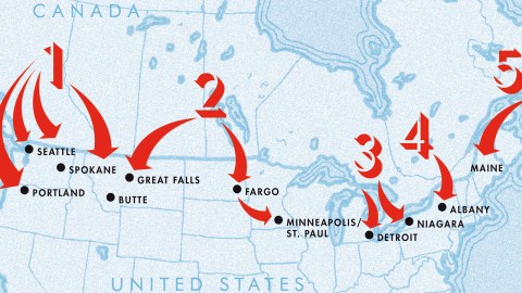
This map shows which routes the Canadians were contemplating. Here’s a summary of the General Instructions for Offensive Action listed in Defence Scheme No. 1:
- The field troops of Canada’s Pacific Command were to advance into and occupy the strategic points including Spokane, Seattle, and Portland, Oregon, bounded by the Columbia River.
- The Prairie Command would converge towards Fargo in North Dakota and then continue a general advance in the direction of Minneapolis and St. Paul. The occupation of Minneapolis and St. Paul would cut most of the lines leading to Duluth and would protect Canada’s railway communications through the Kenora and Rainy River Districts.
- The Great Lakes Command would remain on the defensive, but rapid and well-organized raids would be made across the Niagara Frontier, the St. Clair Frontier, the Detroit Frontier, and the St. Mary’s Frontier, with sufficient troops to establish bridgeheads.
- The Quebec Command would take the offensive on both sides of the Adirondack Mountains with a view of converging in the vicinity of Albany, N.Y.
- The Maritime Command would make an offensive into the State of Maine.

The border between the U.S. and Canada is not just the longest international border between two countries, but these days also called “the friendliest border in the world”. How could things have been so different as relatively recently as the 1920s?
Because back then, Canada was still firmly in the orbit of the British Empire. And the Brits were still not quite ready yet for a ‘Special Relationship’ with the U.S.—in fact, Britain’s demotion from a first- to a second-rate world power—which developed during and after the Second World War.
Instead, the British after the First World War cultivated a special relationship with the Japanese Empire, then firmly in the ascendant. The Americans, already wary of Japanese competition in the Pacific, were worried about the risk of an Anglo-Japanese alliance, which had the potential to turn Canada into hostile territory in case of conflict between the U.S. and Japan.
Canada, in turn, had to consider the potential of its much more powerful southern neighbor turning into a hostile aggressor. It wouldn’t have been the first time. Unbeknownst to many on either side of the 49th parallel, there is quite a violent streak to U.S.-Canada relations, right from the start.
Both during the War of Independence and in the War of 1812, the U.S. tried to invade and conquer what is now Canada—failing twice. In the latter conflict, the British ended up occupying Washington DC and burning down the White House (an aggression Donald Trump recently seemed to want to pin on the Canadians, too).
Subsequent decades saw a number of territorial disputes flare up. The Pork and Beans War of 1838-39 was a conflict over the course of the border between Maine and New Brunswick. The Pig War of 1859 erupted over who controlled the San Juan Islands, between Vancouver and Seattle. Despite their names, both were bloodless conflicts (with the exception of that one pig).
More recently, in the 1960s, the U.S. sent the USS Manhattan through the Northwest Passage, arguing that it was an international waterway. Canada protested, but the U.S. only conceded that they would give advance warning next time.
Still in dispute: Machias Seal Island, off the coast of Maine. The main reason Canada employs a lighthouse keeper instead of automating the signal is to keep the U.S. out.
Right after the First World War, with Britain and Japan in an active alliance (until 1921), the prospect of war with the United States was not entirely unthinkable. Then as now, most of Canada’s population, industry and infrastructure hugged the American border. Despite its enormous size, Canada lacked strategic depth. Hence the Scheme’s strategy to take the fight to the enemy.
Defence Scheme No. 1 was devised by James Sutherland (‘Buster’) Brown, a veteran of the First World War with a healthy suspicion of America’s designs upon his homeland. Part of the preparation for the Canadian plan consisted of concerted, clandestine reconnaissance missions, with Canadian secret agents in Ford Model-Ts driving through the northern U.S., taking pictures and making notes.
In 1920, the U.S. has a population of 106 million, while Canada had about 8 million inhabitants. To overcome that enormous disadvantage, Brown’s plan relied on surprise and speed. In a lightning offensive, Canadian troops would press as far south as Oregon.
In view of the limits imposed by Canada’s numerical inferiority, the plan was to withdraw soon. But not without destroying bridges, roads, factories and other targets – thus creating strategic depth on the other side of the border.
The gamble was that this would disrupt America’ offensive capabilities long enough to give British Imperial forces a window to sail to Canada’s aid. Back then, the British Empire had a total population of 680 million, providing a large base from which to draw troops for the defence of Canada against a U.S. invasion.
Still, a pre-emptive invasion by a much weaker Canada would have been an extremely risky strategy. The plan would probably only have been activated if an American invasion of Canada would have seemed inevitable.
But there would have been a chance that Canada need not start the fight on its own. Defence Scheme No. 1 also lists a number of potential allies in the war against the U.S.:
- “(T)here is not much doubt, in case of war between the British Empire and the United States, that Japan would take immediate military action against the American Republics”.
- “In case of war with the United States, it is not unlikely that Mexico would cause trouble on the Southern Frontier, causing a goodly force of United States’ troops to be concentrated towards Mexico. If Mexico became an active participant in a War against the United States, it would be an area of operation for Britannic or British Empire troops against the Southern States, having for its object the capture of Galveston and New Orleans, and blocking the Mississippi River.”
- “(Many of t)he South American Republics (…) are not hostile to British interests and might decide to support the British Empire. Many of these Republics possess Navies of a useful size which would be a tremendous factor in operations against the Panama Canal.”
This map shows how these allies could coordinate their attacks with those of the Canadians. Japan would invade the West Coast, while Mexico would conduct border incursions. British naval forces could be launched from Mexico against New Orleans. In combination with Canada’s various attacks, this would force the U.S. to divide its forces.

Defence Plan No.1 already foresaw the targets of an American (counter)offensive: not just major urban centres as Montréal, Ottawa and Toronto, Québec, Winnipeg and Vancouver; but also the “grain-growing provinces of Manitoba, Saskatchewan and Alberta, which now have (more than 50%) of Americans (…) there is just a possibility that they might make the conquest of these Provinces the ultimate objective of their campaign”.

America’s own attack plan was first developed by the U.S. Army in 1927, approved by Secretary of War Patrick J. Hurley and Secretary of the Navy Charles Francis Adams III in 1930, and updated in 1934-35.
The Americans were concerned that the British would not be prepared to pay back the considerable war loans to the U.S. Furthermore, the relative rise of the U.S. and decline of the Empire caused tensions between both countries that could conceivably turn into armed conflict.
War Plan Red was a contingency plan to eliminate the ‘red’ – the usual colour of the British Empire on world maps – from North America. The U.S. thought they could muster 12.5 million men in 40 days. As a mirror image of Canada’s ‘pre-emptive invasion’ scheme, War Plan Red focused on the major urban centres just across the border. However, the possibility of a long war with a major naval component was not discounted.
Both the Americans and Canadians had other military schemes. The American ones were colour-coded: War Plan Gray was a scheme to invade the Caribbean, War Plan Black gamed the possibility of war with Germany and War Plan Orange foresaw a war with Japan. War Plan Red-Orange envisages a two-front war against both Japan and Britain.
Canada’s Defence Plans No. 2 concerned with war with Japan, while Nos. 3 and 4 were plans to send Canadian troops for the defence of British interests in Europe and the colonies, respectively.
Defence Scheme No. 1 and its American counterpart faded away as Anglo-American relations continued to improve. The American plans were declassified in the 1970s. Defence Scheme No. 1 was largely an internal discussion within the army, not fully disclosed to the government.

First and third map found here on The Morning News. Both are from the book War Plan Red by Kevin Lippert. Second map found here on TaoYue.com.
Strange Maps #935
Got a strange map? Let me know at [email protected].