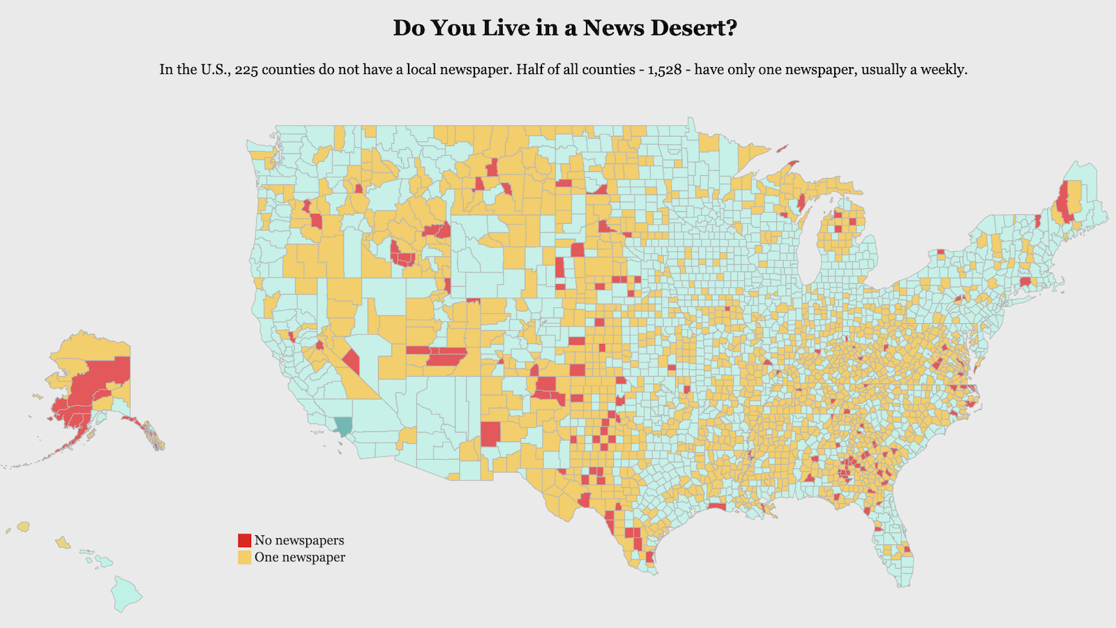
Bigger Than You Think: the Vatican and its Annexes
The Catholic Church has a spiritual leader. The Vatican has a head of state. Two job descriptions, filled by just one single guy [1]: the Pope.
Before he was elevated to the pontificate, Jorge Mario Bergoglio’s tended to the spiritual needs of the 2.5 million souls in his flock, the archdiocese of Buenos Aires. But since his election by the College of his colleagues [2] on March 13 of 2013, the Cardinal became Pope Francis, and thrust upon him were huge spiritual duties, as well as a temporal one, albeit rather smaller.
The new Pope is the numero uno of the Holy See. In its strictest sense, this spiritual jurisdiction only comprises the diocese of Rome. But Rome is where Saint Peter was martyred [3] – and in the Catholic tradition, this Apostle was the first Pope, the current Pope being his 265th successor in an unbroken (though often quite wobbly) line. Hence the primacy of the papacy over other bishops [4], and the conflation of the Holy See with the entire Catholic Church – or at least with the highest echelons of its Roman bureaucracy, also known as the Curia [5].
Under international law, the Holy See is considered a sovereign entity, as it has been since the Middle Ages, and as such maintains diplomatic relations with most other countries. It is a member of various international bodies [6], and has permanent observer status at the U.N. General Assembly. However, the Holy See should not be confused with Vatican City, independent only since the Lateran Treaty of 1929. The two entities issue distinct passports, and they have different official languages: Latin for the Holy See, Italian for Vatican City.

The Vatican’s external borders – or are they?
The Lateran Treaty, concluded between Mussolini’s fascist Italy and the Holy See, sealed the recognition by the Pope of Italy’s authority over the former Papal States [7] and Rome itself, and by Italy of the independence of Vatican City. Thus was resolved the so-called ‘Roman Question’, which had arisen in 1861 when almost-unified Italy had declared Rome its capital, and escalated when the Italian state took Rome from the Pope by deadly force in 1870 [8].
Without the independence of Vatican City, the Holy See’s sovereignty would be comparable to that of the Knights of Malta [9]: with plenty of ambassadors scattered the world over, the Order is considered sovereign – but lacking a territory of its own, the quality of that sovereignty is strained. To avoid a similar conundrum, Vatican City was granted independence, [to] “ensure the absolute and visible independence of the Holy See” and “to guarantee to it an indisputable sovereignty in international affairs” (as explicitly stated in the Lateran Treaty).
So Vatican City is not what you think it is. It is not the diplomatic interface between the Catholic Church and the rest of the world. That role is played by the Holy See, which exchanges ambassadors with most of the world’s countries (rather than Vatican City). Rather, Vatican City is the toehold of sovereign territory that gives the papacy its peace of mind: the territorial buffer shielding the Church’s sovereignty rather than the essence of that sovereignty.
Nor is the Vatican where you think it is. Vatican City’s borders are remarkably fuzzy for a country this tiny. When we say tiny, we mean tiniest: The Papal State is accoladed as the world’s smallest sovereign state, and it is – if you discount those lacklands, the Knights of Malta. Vatican City, completely enclaved within Rome, comprises no more than 108 acres, which is 1/6th of a square mile, or 0.44 of a square km. The second-smallest state, Monaco, is almost five times bigger – huge by comparison [10].
So where is the border between Vatican City and Italy? Centred on Vatican Hill (elevation: 75 m, 250 feet) [11], the Vatican state’s border with Italy is about 3.2 km (2 miles) long. In the south and west, the border follows the 9th-century Leonine Wall [12] – the bastions are clearly visible on the map. Another easily recognisable feature of Vatican City’s outer limits is the roundness of St Peter’s Square; to the north of here, the border is formed by the arrow-straight Via di Porta Angelica.
There are, however, a few grey zones. First, a remarkable counter-enclave, spotted by a contributor to BorderPoint, a Yahoo Groups messageboard for news on and discussions about boundaries and frontiers.
“While doing some research on the Casa Santa Martha, where the cardinals [were] housed during the papal enclave, I ran across [a] WikiMapia [13] map, representing part of the Vatican City State. To the left of St. Martha’s House and St. Charles Palace is the Vatican Train Station. Across from the station is a small trapezoidal area designated as ‘Fontana (it.)’,” said David L. Langenberg. “Does this represent an Italian exclave within Vatican City, itself an enclave within Italy?”

Location of ‘Fontana (It.)’ within Vatican City.
Counter-enclaves are quite rare [14], and the ‘discovery’ of one in a place as well-known as the Vatican, where none had been reported before, would have been spectacular. Unfortunately, the Fontana enclave turned out to be a dud: “[I]t just means that the entry has been created by a WikiMapia user in Italian language”, another BorderPoint contributor weighed in. The entry has now been modified to remove all suggestion of an Italian counter-enclave.

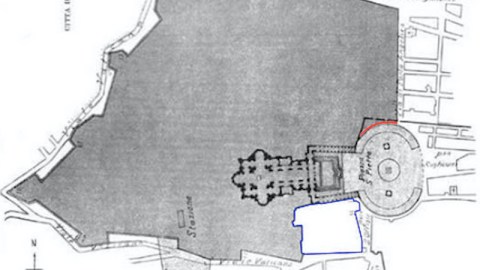
The extraterritorial zone south of St. Peter’s Square.
But mousing over the WikiMapia map does reveal another interesting frontier zone between Italy and Vatican City, an external territory on its southern edge, containing the House of Hospitality, the Palace of the Holy Office, the Santa Maria della Pieta in Camposanto church, the German College and German and Flemish Cemetery (Campo Santo dei Teutonici e dei Fiamminghi), and about two thirds of the Paul VI Audience Hall. This area is officially part of Italy, not of the Vatican; but it has extraterritorial status, meaning that Italian law does not apply here. Many maps simply show it as part of the Vatican.

Blue border: Italian territory on which the Vatican has extraterritorial rights. Red border: territory disputed between Italy and Vatican City.
This map clearly shows the extraterritorial zone, to the left of St Peter’s Square, marked in blue. Interestingly, it notes another curious zone, to the right of the square, marked in red. This is a small strip, just three metres wide and 60 metres long, along the northern colonnade that fringes the square. Italy contends that the Lateran Treaty stipulates that this is Italian territory, but the Vatican disputes this. The difference between both states has remained unresolved since 1932, when a mixed Italian-Vatican commission tasked with demarcating the border agreed to disagree.
But the fuzzy border between the Italian state and the Catholic Church doesn’t stop at the Bernini colonnade, nor is it confined to the outer limits of the Vatican as shown on the maps above. Scattered throughout Rome are a baker’s dozen of churches and other buildings of special significance, often housing the offices of the Roman Curia, that have been granted extraterritorial status by the Lateran Treaty without being part of the independent Vatican City. This map is taken from a 1931 issue of the Geographical Journal [15], and shows the Holy See’s extraterritorial areas as they were then. The article explains:
“Another interesting feature of the Vatican State is the number and extension of areas beyond its boundaries, in Italian territory, on which it enjoys extraterritorial rights, and therefore a very large and almost supreme authority. Italy has agreed to exempt these areas from taxes and from obedience to the law of expropriation for public utilities: papal authorities are entrusted with internal police service. As respects postal and telegraphic service they are considered to belong to the Vatican.”
“The problem of communications between the organs of the state and extraterritorial areas has been solved by allowing those persons or documents employed for official intercourse between the state and the extraterritorial zones to be provided with diplomatic guarantees.”

Vatican City State (V.C.S.) and some of the Holy See’s extraterritorial possessions across Rome, as shown in the Geographical Journal of 1931.
“Such areas cover a surface of about 170 acres [16]. The largest (nearly 100 acres) is formed by the Papal Palace, Villa and Palazzetto Cybo, and Villa Barberini at Castelgandolfo – a group of estates that was already acknowledged as a summer residence of the pope by the Guarantee Act of 1870. The second consists of Villa Gabrielli and its environs, on the Gianicolo Hill, whose entrance is quite near the Vatican City; it covers 35 acres and is reserved for the new buildings that may become necessary in the future. Between this and the Vatican there is still another small area with the Palace of the Holy Office.”
“The other areas are nearly all occupied by churches and palaces that have long been the seat of central offices of the Holy See:”
[the following list reflects the current situation]
- Basilica di San Giovanni in Laterano
The Papal Archbasilica of St. John Lateran (consecrated in 324 AD), a.k.a. the Lateran Basilica, is the official church of the Bishop of Rome – a.k.a. the Pope. As such, it is higher in rank even than St. Peter’s Basilica, and is considered by Catholics to be the ‘Mother Church’ of all churches throughout the world. It was known as the Golden Basilica until the Vandals vandalised it. The basilica contains the Holy Steps, believed to be the staircase leading to Pontius Pilate’s office in Jerusalem. Curiously, the honorary canon of the basilica is François Hollande, President of France. French heads of state have held this title since King Henry IV (1553-1610) [17].
- Palazzo del Laterano
The Lateran Palace, next to the Lateran Basilica, once was the homebase of the Laterani family, a dynasty of Roman Imperial administrators. It was given to the Bishop of Rome by the Emperor Constantine and used as the main papal residence throughout much of the following centuries. It was also used as an orphanage, a silk factory (in which the orphans were employed), and at present as a museum. It was here that the Lateran Treaty was signed, on 11 February 1929.
- Basilica di Santa Maria Maggiore
The Papal Basilica of Saint Mary Major, originally built immediately after the Council of Ephesus in 431 at which Mary was proclaimed theotokos, i.e. Mother of God, is one of only four Major Basilicas, the others being St. John Lateran, St. Peter and St. Paul outside the Walls. Commonly known as St. Mary Major’s, it is the largest of the 26 Roman churches dedicated to Mary, hence the epithet. It used to be known as Our Lady of the Snows, after a legend of its origin: summertime snowfall on the Esquiline Hill pointed out the place where it should be built. Another name was St. Mary of the Crib, because of four woodboards allegedly part of Jesus’ crib (a relic still revered at the church). It was this church that Pope Francis visited on the first day after his election. The protocanon (whatever that is – although it sounds lethal) by right of office of this church is the present King of Spain, Juan Carlos I.
- Basilica di San Paolo fuori le mura
The Papal Basilica of Saint Paul outside the Walls, was founded by Emperor Constantine I. It was built outside Rome’s city walls, on the spot along the Via Ostiense where St. Paul was buried. On an original 5th-century mosaic, St. Paul can be seen pointing downwards to his tomb – which is said only to contain his headless body. The Apostle’s head rests at the Basilica of St. John Lateran.
- Palazzo San Callisto
The relatively small Palace of St. Callixtus houses a number of Papal Councils and Catholic organisations linked to the Holy See, including the relief agency Caritas Catholica.
- Palazzo di Propaganda Fide
The baroque Palace for the Propagation of the Faith, at the Piazza di Spagna, is the seat of the Vatican’s Jesuit College. It contains Borromini’s Chapel of the Three Magi.
- Palazzo della Cancelleria
The Papal Chancellery, built around 1500, supposedly from a fortune won in a single night’s gambling. It is considered the first Renaissance building in Rome. It incorporates a 5th-century basilica built on a pagan mithraeum [18], and includes a mural by Vasari, completed in 100 days. When the artist boasted of this to Michelangelo, the latter replied: Si vede (‘It shows’).
- Palazzo del Sant’Uffizio
The Palace of the Holy Office houses the Congregation for the Doctrine of the Faith, formerly known as the Inquisition, Cardinal Ratzinger’s old job before he became (the previous) Pope. Like the Paul VI Audience Hall, it lies adjacent the Vatican in the extraterritorial area marked blue on the map above.
- Palazzo dei Convertendi
This Palace housed the Congregation for the Oriental Churches. It was also known as the Palazzo di Raffaelo, because the artist of that name died here in 1520. Its more recent name refers to the convertendi, the converts and reverts to Catholicism, after a hospice on this location for those willing to (re)enter the faith.
- Santa Maria di Galeria
Vatican Radio, set up in 1931 by broadcasting pioneer Guglielmo Marconi and run by the Jesuit order, acquired a 400-hectare (4 sq. km, 1.5 sq. mi) area 18 km (11 mi) north of Rome at Santa Maria di Galeria for its transmitters. The Italian government granted the site extraterritorial status in 1952.
- Palazzo del Vicariato
A.k.a. the Palazzo Maffei Mascerotti.
- Several buildings on the Janiculum Hill
The Villa Gabrielli al Gianicolo, housing the Pontifical North American College and the Pontifical Urban University, and the Ospedale pediatrico Bambino Gesu (Baby Jesus Children’s Hospital). In antiquity, the Janiculum Hill was dedicated to the god Janus. Like the Vatican Hill, it is west of the Tiber outside of Rome’s ancient boundaries, and thus not one of Rome’s original Seven Hills.
- Pontificio Seminario Romano Minore
The Minor Roman Pontifical Seminary specifically trains clerics who will serve St. Peter’s Basilica.
- Basilica Santa Maria in Trastevere
Dating back to the 220s, when a house-church stood on this location, this is one of the oldest churches in Rome. It might even be the one in which Mass was celebrated openly for the first time. The basilica keeps a relic of the Holy Sponge, used to offer vinegar to Christ during his Passion (other parts of the Sponge are kept in other churches).

Marked on this map of Castel Gandolfo are: (1) the papal palace with adjacent garden; (2) the garden of the Villa Cybo; (3) the Villa Barberini, adjacent gardens and agricultural area; (4) the olive grove formerly known as Bacelli; (5) the church of San Tommaso di Villanova.
Here is a link to the WikiMapia map of the Vatican City area. Find the Geographical Journal map of the Vatican’s extraterritorial locations here. A link to the map showing the extraterritorial area to one side of St. Peter’s Square, and the disputed corridor to the other side is here. The Castel Gandolfo map is here.
Strange Maps #601
Got a strange map? Let me know at s[email protected].
[1] Yes, it’s always a guy. And yes, he’s always single. ↩
[2] Cardinals are ‘princes of the Catholic Church’. They are appointed by the Pope, and collectively, they choose the next Pope. There are currently 223 cardinals, of which 117 are under the age of 80, and thus eligible to vote in the papal election. ↩
[3] St. Peter’s Basilica is built right on top of Nero’s old Circus, where Peter was put to death. Peter’s primacy is based on Matthew 16:18, in which Jesus tells Peter: “And I say also unto thee, That thou art Peter, and upon this rock I will build my church; and the gates of hell shall not prevail against it.” Jesus was not averse to a bit of punning: the Greek petros means ‘rock’. ↩
[4] In Catholicism, the Pope is the Vicar of Christ (i.e. the representative of Christ on Earth), and supreme head of the Church, elevated above the other bishops. But to the Eastern Orthodox, the Pope is merely the primus inter pares (‘first among equals’) of the Pentarchy of ancient Patriarchal Sees (Rome, Constantinople, Alexandria, Antioch and Jerusalem).↩
[5] The Roman Curia is the bureaucratic apparatus of the Holy See that governs the Catholic Church.The Secretariat of State is the only body of the Curia that is situated within Vatican City. ↩
[6] Including the International Telecommunication Union and the International Atomic Energy Agency. The thought of the Church with the Bomb would make one think twice before taking the Lord’s name in vain, or using a condom. ↩
[7] The Papal States were territories, mostly in Italy, under the direct rule of the Pope. They existed in one form or other from the 6th century until 1870, when the disparate territories of Italy were unified in a single state. In their most extensive form, the Papal States stretched from the Ligurian to the Adriatic Seas, covering what are now the Italian regions of Romagna, Le Marche, Umbria and Lazio. ↩
[8] For the almost six decades since then, successive Popes considered themselves ‘prisoners in the Vatican’, and at various times considered exile from Rome, in England, Germany, Malta and Trent (in northern Italy, under Austro-Hungarian rule until 1918). ↩
[9] A.k.a. the Sovereign Military Order of Malta (SMOM), it was founded in the Holy Land around 1050, and it is the world’s oldest surviving order of chivalry. The SMOM was granted sovereign status by the Holy See, and once controlled the islands of Rhodes, and later Malta. After its ejection from the latter by Napoleon in 1798, it was reduced to being sovereign without a territory. At present, it is based in the palazzo Malta in Rome, which, together with a few other of its possessions, enjoys extraterritorial status (like an embassy). The Order exerts a few essential functions of a sovereign state: it issues coins, stamps, passports, car licence plates, and citizenship (although the only three persons to carry SMOM passports are the Order’s Grand Master, its Deputy Grand Master, and its Chancellor. Its other 13.000 members remain citizens of their original countries). ↩
[10] And it used to be even bigger. See: #82. ↩
[11] Not one of the Seven Hills on which Rome was built. Those are all situated on the west bank of the Tiber, where the centre of the ancient city was. They are: the Aventine, the Caelian, the Capitoline, the Esquiline, the Palatine, the Quirinal, and the Viminal. ↩

[12] The Leonine Wall enclosed the Leonine City, both named after Pope Leo IV who commissioned their construction. After their take-over of Rome in 1870, the Italian government initially offered the entire Leonine City to the papacy. Vatican City as it is now covers only a part of it. ↩
[13] An open-content collaborative mapping project aiming to mark and describe all geographical objects in the world, with over 20 million marked at present. ↩
[14] See the enclaves and counter-enclaves of Baarle (#52), of Madha and Nahwa (#60), and the enclaves, counter-enclaves, and the world’s only counter-counter-enclave, in Cooch Behar (#110). ↩
[15] An academic quarterly issued by the Royal Geographical Society (UK), first published in 1831. Recent issues are accessible here. ↩
[16] more than doubling the ‘official’ area of the Vatican, which is 108 acres. ↩
[17] French Presidents are also co-princes ex officio of Andorra, the other prince being the Bishop or Urgell. ↩
[18] The grotto-like gathering places of the mysterious Mithraic cult, which flourished throughout the Roman Empire in Late Antiquity, but was completely erased by Christianity. ↩


