Huge color-coded map shows the world’s most ancient and recent borders
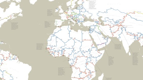
Borders between countries are inviolable and immutable: That’s the principle which underpins the international order. If changing them is such a big deal, those international borders must be venerably ancient. Wrong! As this map shows, more than half their total length was delineated after 1900. Less than 1% of the world’s current land borders were drawn up before the year 1500.
The oldest border has a specific birthday: 8 September 1278. That’s when Roger-Bernard III, the count of Foix, and Pere d’Urtx, the bishop of Urgell signed the so-called Tractat de pareatge. This feudal charter established their joint sovereignty over the mountain territory of Andorra and fixed its borders.
The county of Foix has been extinct since 1607, but the charter still holds: high in the Pyrenees that separate France from Spain, Andorra continues its existence as an independent condominium. Its ceremonial heads of state (officially ‘co-princes’) are the bishop of Urgell and—as the legal successor of the counts of Foix—the president of France.
The remarkable longevity of the arrangement makes Andorra’s borders the oldest ones in the world (1). This September, they will be celebrating their 740th birthday.
On the other end of the spectrum is the northern border of South Sudan, the world’s newest country since it voted to split from Sudan in 2011. However, the new border itself is older than independence: it’s made up of bits demarcated in 1924, 1956 and 1960—all when those borders were still well within the unified Sudanese state.
The only exception is Abyei, an oil-rich region disputed between Sudan and South Sudan. Its borders were defined in 2009 by the Permanent Court of Arbitration at The Hague. That makes them the youngest international border in the world—sort of: while its status remains in dispute, it’s unclear whether the northern or southern segment of the dotted line encircling the region will end up separating Sudan from South Sudan (2) (3).

As indicated by the South Sudanese example, borders can be much older than the countries they separate. Take for instance the land border of East Timor (4), the first nation to gain independence in the 21st century. It voted to secede from Indonesia in 2002. The new international border was decided by neither country: it was fixed by their former colonial overlords, Portugal and the Netherlands, back in 1902.
This map was put together by Reddit user PisseGuri82, who traced each currently existing border to the earliest codification he could find. The map does not take into account older borders that were not officially defined, nor more recent border corrections that were relatively minor. That is an imperfect method, leaving much room for discussion, and improvement.
“However,” says the mapmaker, “I’m hoping this overview gives an interesting look into how the concept of modern borders has spread throughout the world, in which regions they’ve meandered, where they’ve settled in and where they were simply imposed once and for all.”
According to this map, which colour-codes the borders according to period, the total sum of international land borders in the world is 256,613 km (159,452 miles). Some 52.2% of that total was defined in the 20th century, and a further 37.1% came about in the 19th century.
Compare that to the long stretch of history from the start of the 13th to the end of the 18th century: 600 years, producing no more than 9.6% of the world’s current borders. Just 0.4% were set after the year 2000. Double that amount, about 2,200 km (1370 miles) remains to be defined.
Let’s have a closer look at some of the world’s borders—click here to explore the zoomable map.
- The U.S. has land borders with just two countries: Canada and Mexico. For the most part, they came about in the 19th century. The Alaska Panhandle has the youngest border, defined only in 1903. The only stretch older than the U.S. itself is the border demarcating Québec in Canada from New York and Vermont in the U.S.: drawn up in 1763, more than a decade before American Independence.

- Upon gaining independence from Spain, Latin American countries generally followed the uti possidetis principle, respecting the colonial borders as they existed at the time (i.e. 1810). Various conflicts between the new states have led to new borders, many dating well into the 20th century. Part of the border between Ecuador and Peru still dates from 1810, but most of it is from 1942, making it the youngest border in Latin America.

- The Treaty of Madrid (1750) defined the border between the South American possessions of Portugal and Spain. Much of the borders of Brazil with its neighbors still date to that treaty, making them the oldest borders in the Americas.
- The oldest international demarcation in Africa is the northern part of the Morocco-Algeria border, defined in 1842. Many African borders date back to the Berlin Conference (1884-85), where Europe’s colonial powers divided up the continent between them. A large part of Africa’s borders was defined in the 20th century—notably the ones between countries in western Africa, when they were still French colonies (and those borders thus still were of secondary importance).
- A surprisingly late border is the one between Saudi Arabia and Yemen, most of which was defined as recently as the year 2000. Neighboring country Oman’s borders are not much older: All were defined in the 1990s. Traveling north, the same goes for at least part of the borders with Saudi Arabia of the UAE (1970s), Iraq (1980s), Qatar, Kuwait and Jordan (1960s).

- The Treaty of Zuhab (1639) ended a war between the Ottoman and Safavid Empires and established what is now the border between Iran on one side, and Turkey and Iraq on the other. It is the oldest border in Asia.
- The Line of Control between India and Pakistan is Asia’s youngest international border. It was established when the Simla Agreement (1972), the peace treaty which ended the Indo-Pakistani War of 1971, converted the cease-fire line between both sides into a more permanent arrangement, which India and Pakistan pledged to respect, “irrespective of mutual differences and legal interpretations.” However, Pakistan has denied Indian allegations that leaders of both countries had agreed to turn the LOC into a full-fledged international border.
- Many borders on the Indian subcontinent still carry the name of the British officials who drew them. The Durand Line (1896) divided British India from Afghanistan. It remains poorly marked, highly porous and, to the local Pashtun who live on either side, an irritant or at best an irrelevance. The Macartney-MacDonald Line (1899) was drawn south of the Johnson Line, granting China a larger portion of the disputed Aksai Chin region. Pakistan and China have adopted the line as the basis for their common border. It has been suggested that India and China do the same to resolve their border dispute in the region. As it is, they are separated by the mutually recognized cease-fire line of 1962. The McMahon Line (1914) agreed between Britain and the then independent state of Tibet, establishing India’s border with China (but disputed by the latter). The Radcliffe Line (1947) partitioned British India in two separate states: mainly Muslim Pakistan and mainly Hindu India. What followed was a massive population exchange—up to 14 million people moving across the new borders and up to two million dead of disease, starvation or intercommunal violence.

- The border between China and (North) Korea is the oldest one in East Asia, even though it was formalized only in 1712, long after its first introduction in the 15th century. The border between North and South Korea is one of the youngest ones in Asia: basically, the cease-fire line at the end of the Korean War (1953).
- Mongolia’s northern border with Russia also largely dates from the 18th century—from the Treaty of Kyakhta (1727), to be precise, but its southern border with China is an entirely 20th-century construct, with large parts as young as 1962.
- Europe is home to some of the world’s oldest international borders. But three relatively recent events have generated a lot of fairly new borders: the Congress of Vienna (1815), resetting European order after the Napoleonic wars; and the Treaty of Versailles (1919) and the Potsdam Conference (1945), doing the same after the First and Second World Wars.

- The eastern border of the Russian exclave of Kaliningrad is remarkable, and not just for its antiquity. First established at the Treaty of Melno (1422) between the Teutonic Knights and the Grand Duchy of Lithuania, it was long the easternmost border of the German Empire, with the Russians on the other side. After the fall of the Soviet Union in 1990, it became an international border again, but with the Russians now on the other, western side of the border.
- Even though Yugoslavia fell apart in the 1990s, the borders of the new republics are all much older, dating back as far as 1683, when the Ottomans and Austrians were the dominant regional powers. A lot of local borders owe their existence to the First Balkan War (1913) and the Second World War (1945). Yugoslavia’s northern border with Italy around the disputed territory of Trieste was settled only in 1954. But apparently the last word on former Yugoslav borders hasn’t been spoken yet. Kosovo and Montenegro, the two youngest ex-Yugo countries, are still going through a demarcation process. If that leads to significant changes, perhaps they will snatch the title of world’s newest international border from Abyei.


Many thanks to Jana Roose for sending in this map, found here on Reddit‘s MapPorn page.
Strange Maps #932
Got a strange map? Let me know at [email protected].
(1) At least according to this map. Some stretches of the Spanish-Portuguese border may be older, some commenters on Reddit have pointed out. The mapmaker has promised to produce an updated version of the map.

(2) Until such time when a referendum can be held to determine the permanent status of the Abyei Area, its 125,000 residents are considered to be simultaneously citizens of both Sudan and South Sudan. It’s the world’s largest-scale experiment with Heisenberg’s uncertainty principle to date.
(3) Actually, the newest border on this map is a line drawn across Antarctica – but since territorial claims are frozen on the Frozen Continent, borders are even more hypothetical on Earth’s southernmost continent than anywhere else.
(4) Your eyes aren’t deceiving you: East Timor is mislabelled on this map – it’s placed over West Timor, which remains a part of Indonesia.