Just How Much Land Does the Federal Government Own — and Why?
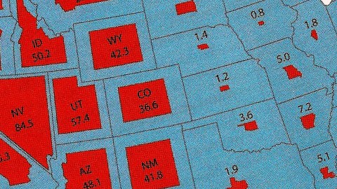
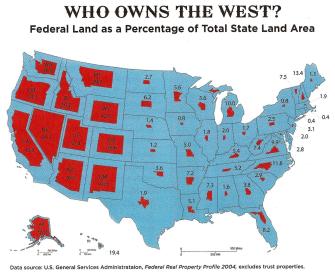
The rough beauty of the American West seems as far as you can get from the polished corridors of power in Washington DC. Until you look at the title to the land. The federal government owns large tracts of the western states: from a low of 29.9% in Montana, already more than the national average, up to a whopping 84.5% in Nevada.
This map, depicting the distribution and share of federal land per state, was first published on this blog way back in 2008. Nevertheless, it keeps accumulating comments and hits at a steady pace, and is still frequently shared around. Unlike hundreds of other random maps, this one has become a perennial. That raises an interesting question for map geeks like yours truly: Which nerve, exactly, does this map strike with the Great Online Public?
Let’s start with the most obvious answer: the map is stunningly effective at bringing home its message. And that message is: Federal land ownership out west is huge.
Few minds will stir when they learn that the US federal government owns a grand total of 640 million acres of land: that figure is so vast that it becomes meaningless [1]. The sum of all that acreage adds up to about 28% of the nation’s total surface, 2.27 billion acres. That sounds like a lot, but since it is an average, and because we have nothing to compare it to, that percentage is, to use one of my favorite quotes, “the kind of information they conceal in books” [2].
Both issues – the blandness of averages, the lack of comparison – are eliminated by the map, which presents an immediate, jaw-droppingly clear frame of reference. In the blink of an eye, the contrast between the west and the rest becomes clear.
The clever device delivering that instant insight: 50 icons, each shaped like the particular state they are centered on and sized to reflect the percentage of the federal lands in each particular state.
Back east, but even in the Midwest, those icons – colored red for better contrast – barely amount to a distant mirror of the state they’re modelled on. In those parts, the federal share of state territory rarely runs into the double digits. It even stays below 2% for the Top 10 states with the lowest percentage of federally owned land:

The largest splotches of red are all in the 11 westernmost states of the Lower 48. The federal government’s enormous share of Alaska is only less obvious because as usual the largest state in the Union is shown in an inset map, at a much larger scale [3].
These red icons look like parasites, about to take over the body of the host. Take a look at poor Nevada, where non-public land is pushed out to a narrow band skirting the state’s borders – marginalized, in the most literal sense of the word. Even in most other western states, that ledge is not much wider than a toehold.
The Top 10 list of states with the highest percentage of federally owned land on this map looks like this:

Both because of its enormous total size and its huge percentage of federal lands, Alaska alone represents almost half the government-owned area in the 10 most ‘federalised’ states combined. The only two western states falling out of the Top 10 are Montana (29.9%) and Washington state (30.3%).
What is all that federal land for? And exactly who is in charge? According to the Congressional Research Service [4], a total area of just under 610 million acres – more than twice the size of Namibia – is administered by no more than 4 federal government agencies:
* The United States Forest Service (USFS), which oversees timber harvesting, recreation, wildlife habitat protection and other sustainable uses on a total of 193 million acres – almost the size of Turkey – mainly designated as National Forests.
* The National Park Service (NPS) conserves lands and resources on 80 million acres – a Norway-sized area – in order to preserve them for the public. Any harvesting or resource removal is generally prohibited.
* the Bureau of Land Management (BLM), managing 248 million acres [5] – an area the size of Egypt – has a multiple-use, sustained-yield mandate, supporting energy development, recreation, grazing, conservation, and other uses.
* the Fish and Wildlife Service (FWS) manages 89 million acres – an area slightly bigger than Germany – to conserve and protect animal and plant species.
The first agency is part of the Department of Agriculture, the latter three of the Department of the Interior. The Department of Defense manages an additional 20 million acres – a bit larger than the Czech Republic – as military bases, testing and training grounds, etc.
Back to the map – apart from making its point in such an excellent manner, why is it so popular? The aforementioned Congressional Overview of Federal Land Ownership provides a broad outline of the answer:
“47% of the 11 coterminous western states [is federally owned]. By contrast, the federal government owns only 4% in the other states. This western concentration has contributed to a higher degree of controversy over land ownership and use in that part of the country”.
“Throughout America’s history, federal land laws have reflected two visions: keeping some lands in federal ownership while disposing of others. From the earliest days, there has been conflict between these two visions. During the 19th century, many laws encouraged settlement of the West through federal land disposal. Mostly in the 20th century, emphasis shifted to retention of federal lands.”
That conflict came to a head very publicly last year with the case of Cliven Bundy, a Nevada rancher whose conflict with the Bureau of Land Management over grazing rights led to the federal government impounding his cattle [6].
But the federal government’s extra-extra-large involvement in the management of western lands is far more than a conflict about grazing, water, mining, logging and other development. It pits the principle of good stewardship of the land, for the welfare of present and future generations, against one of America’s foundational axioms: That government is best which governs least [7].
The former attitude requires a central government to assume authority, restrict access, punish rule-breakers – and increasingly so, since resource depletion is a growing threat.
The latter viewpoint holds government intervention to be the problem, not the solution, and the stated reasons for it – be it conservation or climate change – as convenient cover stories at best.
Two quotes from the story’s comments section illustrate the gap between the two extremes:
“It’s too late [to take back our country]. Jump ship and buy land in a poor undeveloped country, Start a farm and build a new community.”
“Or we could stop wasting time with this nonsense and get back to the real issues.”
Ultimately, this map reverberates and keeps bouncing around the internet because it touches a divide in American politics and wider society that is about much more than land use. It pits libertarians versus federalists, with the gap between them increasing to such an extent that the former often seem to the latter to be no more than right-wing vigilantes, the latter to the former nothing less than world-government-promoting socialists. Until some middle ground emerges to bridge that divide, this map (and other incendiary devices) will continue to add fuel to the ideological fire.
Many thanks to Jonathan Leblang and Adam Hahn for signaling this map, which appeared as an illustration to ‘Can the West Lead Us To A Better Place?‘, an article in Stanford Magazine, a periodical for and about alumni from that university. Update: the map can be found in higher resolution – and with a long, long comments section – here on Reddit.
Strange Maps #291
Got a strange map? Let me know at [email protected].
[1] Remember the Joseph Stalin quote: “One death is a tragedy, one million is a statistic”. Not that one acre is a tragedy. But you catch our meaning.
[2] Oliver Platt as Hector Cyr in Lake Placid (1999).
[3] Contrary to intuition, map objects shrunk to fit in with others are shown at a larger, not a smaller scale. See the scales at the bottom: Alaska’s 500-mile line is 4 times shorter than the Lower 48’s. Meaning (a) that Alaska is shown 4 times smaller than the Lower 48; and (b) that if Alaska’s scale would have been as long as the other, it would have measured 2,000 miles – i.e. would measure a larger distance.

[4] Federal Land Ownership: Overview and Data
[5] The BLM is also responsible for subsurface mineral resources in areas totaling 700 million acres.
[6] The sentiment is often attributed to Jefferson, but the quote as such is from the opening lines of Henry David Thoreau’s Civil Disobedience.
[7] Mr. Bundy refused to pay $1.2 million in grazing fees to the BLM, arguing that the land his cattle uses belongs not to the federal, but the state government. In the spring of last year, BLM officials agreed to leave his property and release his cattle after hundreds of armed supporters showed up at the Bundy ranch. As the Washington Postrecently reported, the conflict remains unresolved.