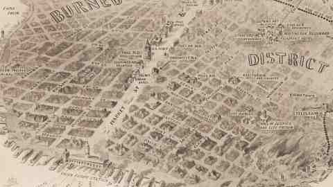
A Bird’s Eye View of San Francisco Destroyed by Fire
On the night of April 17th in 1906, the world-famous tenor Enrico Caruso wowed San Franciscans at the Tivoli Opera House with his performance in Carmen. The next day would – unfortunately – prove much more memorable for San Francisco. That Wednesday morning, at twelve minutes past five, an earthquake with a magnitude of 7,8 on the Richter scale struck the Bay Area.
The quake lasted 42 seconds, causing severe damage. Ruptured gas lines (and the scarcity of water due to ruptures in those lines) caused city-wide fires that eventually were responsible for up to 90% of the total destruction. Additionally, since the insurance companies didn’t refund the actual quake damage, many people set fire to their own homes. The fires raged for four days and nights. By that time, 80% of the city was destroyed. Estimates of the damage range from $500 million to as high as $1 billion (equivalent to at least $300 billion in today’s money).
The army was brought in to control the fires (which they did with dynamite and even artillery barrages) and stop the looting. In all, 500 presumed looters were shot. Some destruction and loss of life occurred outside San Francisco, but the bulk of the 3,000 casualties were to be regretted in the Golden Gate city itself. Three quarters of its population of 400,000 were made homeless. Half of those fled across the Bay to Oakland and Berkeley, others took up residence in massive camps of shacks and tents at Golden Gate Park and the Presidio, among other places.
Some of those camps were still open in 1908, indicating the slowness of the rebuilding effort (the city wouldn’t be considered ‘rebuilt’ until the Exposition of 1915). Up until then, San Francisco had been the undisputed economic centre of the West Coast. Los Angeles profited from the diversion of trade, industry and population, and eventually overtook its rival to the north.
This map was drawn by H.M. Pettit for Leslie’s Weekly, a famous American illustrated news magazine founded in 1852 and operating well into the 20th century, when some of its covers were drawn by Norman Rockwell. As befits a news weekly founded by an engraver, (Frank) Leslie’s Weekly featured a fair share of maps, illuminating a contemporary news story. This map’s title and subtitle are of a charming, old-school length and descriptiveness: Destruction of One of the Greatest Modern Cities. Bird’s-Eye view of Stricken San Francisco, Showing the Burned District, Covering Twenty-Five Square Miles, With the Most Prominent Places and Buildings Carefully Indicated.
Oriented to the southwest, the map surrounds the Burned District with a dotted line, from the Union Iron Works at the left side of the map up to Twin Peaks in the centre of the peninsula, and then along Van Ness Avenue almost to the Bay, taking a right on Greenwich Street via Telegraph Hill to the water, sparing the area around Fisherman’s Wharf. In total, about 500 city blocks were destroyed. Some significant locations are spelled out on the map:
And Caruso? Clutching an autographed photo of President Theodore Roosevelt, he made an effort to get out of the city, first by boat and then by train, and vowed never to return to San Francisco. He kept his word.

Map found here at the excellentPJ Mode Collection of Persuasive Maps.
Strange Maps #161
Got a strange map? Let me know at[email protected].